Property Record
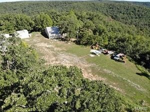
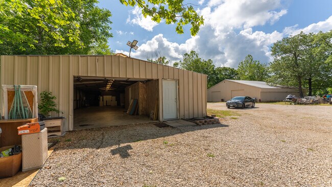
155 Trailer Rd, Camdenton, MO 65020

Property Detail
155 Trailer Rd
13-7.0-35.0-000.0-001-002.001
PT NWNE
Commercialnec
CAMDEN
B and X Area of moderate flood hazard, usually the area between the limits of the 100-year and 500-year floods.
Missouri
2025
25.90 AC
2025
Missouri South Central Area
950402
Other Market Areas
NEARBY LISTINGS FOR SALE OR LEASE
-
-
View all Camdenton listings for sale on LoopNet.com
DEMOGRAPHICS near 155 Trailer Rd
1 mile
3 mile
5 mile
2025 Total Population
876
5,515
8,758
2030 Population
804
5,250
8,429
Pop Growth 2025-2030
(8.22%)
(4.81%)
(3.76%)
Average Age
39
42
42
2025 Total Households
341
2,213
3,472
HH Growth 2025-2030
(9.09%)
(5.38%)
(4.26%)
Median Household Inc
$52,307
$54,221
$56,440
Avg Household Size
2.40
2.40
2.40
2025 Avg HH Vehicles
2.00
2.00
2.00
Median Home Value
$194,329
$250,116
$260,837
Median Year Built
1999
1994
1994
Nearby Places
Map Layers
Map Styles
 Street
 Aerial
Transit
 Traffic
 Biking
Places
Listings with unknown addresses are not visible on the map
- Restaurants
- Banks
- Shops
- Fitness
- Groceries
SALE & LEASE HISTORY
LISTING DATE
SALE/LEASE

Nov 13, 2018
For Sale
Jun 01, 2024
For Sale
Jan 14, 2019
For Sale
Nearby Properties
Address
Land Use
TOTAL SIZE
Lot Size
Zoning
Address
Land Use
TOTAL SIZE
Lot Size
Zoning
16.60 AC
Address
Land Use
TOTAL SIZE
Lot Size
Zoning
5.98 AC
Address
Land Use
TOTAL SIZE
Lot Size
Zoning
12.36 AC
Address
Land Use
TOTAL SIZE
Lot Size
Zoning
Address
Land Use
TOTAL SIZE
Lot Size
Zoning
5,792 SF
18 AC
Address
Land Use
TOTAL SIZE
Lot Size
Zoning
10,140 SF
120.78 AC
Address
Land Use
TOTAL SIZE
Lot Size
Zoning
2.30 AC
Address
Land Use
TOTAL SIZE
Lot Size
Zoning
Address
Land Use
TOTAL SIZE
Lot Size
Zoning
18,153 SF
1.81 AC
Address
Land Use
TOTAL SIZE
Lot Size
Zoning
5,176 SF
2.05 AC
Address
Land Use
TOTAL SIZE
Lot Size
Zoning
19,640 SF
1.84 AC
Address
Land Use
TOTAL SIZE
Lot Size
Zoning
64.90 AC
Address
Land Use
TOTAL SIZE
Lot Size
Zoning
1.20 AC
Address
Land Use
TOTAL SIZE
Lot Size
Zoning
416 SF
2.05 AC
Address
Land Use
TOTAL SIZE
Lot Size
Zoning
44,857 SF
4.20 AC
Address
Land Use
TOTAL SIZE
Lot Size
Zoning
10,897 SF
0.99 AC
Address
Land Use
TOTAL SIZE
Lot Size
Zoning
Address
Land Use
TOTAL SIZE
Lot Size
Zoning
Address
Land Use
TOTAL SIZE
Lot Size
Zoning
4,032 SF
2 AC
Address
Land Use
TOTAL SIZE
Lot Size
Zoning
4,974 SF
1.30 AC
Address
Land Use
TOTAL SIZE
Lot Size
Zoning
2.30 AC
Address
Land Use
TOTAL SIZE
Lot Size
Zoning
9,141 SF
0.70 AC
Address
Land Use
TOTAL SIZE
Lot Size
Zoning
Address
Land Use
TOTAL SIZE
Lot Size
Zoning
Address
Land Use
TOTAL SIZE
Lot Size
Zoning
3,150 SF
0.34 AC
Address
Land Use
TOTAL SIZE
Lot Size
Zoning
3,000 SF
0.46 AC
Address
Land Use
TOTAL SIZE
Lot Size
Zoning
11,250 SF
0.85 AC
Address
Land Use
TOTAL SIZE
Lot Size
Zoning
3,494 SF
0.76 AC
The World's #1 Commercial Real Estate Marketplace
Connect with us
© 2026 CoStar Group
The information above has been obtained from sources believed reliable. While we do not doubt its accuracy we have not verified it and make no guarantee, warranty or representation about it. It is your responsibility to independently confirm its accuracy and completeness. Any projections, opinions, assumptions, or estimates used are for example only and do not represent the current or future performance of the property. The value of this transaction to you depends on tax and other factors which should be evaluated by your tax, financial, and legal advisors. You and your advisors should conduct a careful, independent investigation of the property to determine to your satisfaction the suitability of the property for your needs.