Property Record
155 Treat Rd, Aurora, OH 44202
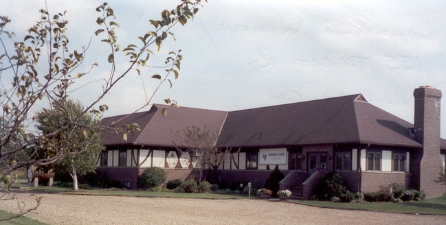

Property Detail
155 Treat Rd
Akron, OH
LOT 15 S E
03-015-00-00-003-003
Portage
Bartavern
Ohio
B and X Area of moderate flood hazard, usually the area between the limits of the 100-year and 500-year floods.
15
2025
7.25 AC
2025
Portage County
600303
Cleveland
6,121 SF
NEARBY LISTINGS FOR SALE OR LEASE
DEMOGRAPHICS near 155 Treat Rd
1 mile
3 mile
5 mile
2025 Total Population
1,929
21,996
52,810
2030 Population
1,979
22,060
52,795
Pop Growth 2025-2030
+ 2.59%
+ 0.29%
(0.03%)
Average Age
43
44
44
2025 Total Households
801
8,504
19,833
HH Growth 2025-2030
+ 2.62%
+ 0.25%
(0.04%)
Median Household Inc
$137,500
$116,616
$120,846
Avg Household Size
2.40
2.50
2.60
2025 Avg HH Vehicles
2.00
2.00
2.00
Median Home Value
$567,510
$388,569
$401,030
Median Year Built
1996
1989
1990
Nearby Places
Map Layers
Map Styles
 Street
 Aerial
Transit
 Traffic
 Biking
Places
Listings with unknown addresses are not visible on the map
- Restaurants
- Banks
- Shops
- Fitness
- Groceries
PUBLIC TRANSPORTATION
AIRPORT
Cleveland-Hopkins International
Drive
Walk
Distance
Cleveland-Hopkins International
48 min
33.0 mi
Akron-Canton Regional
Drive
Walk
Distance
Akron-Canton Regional
59 min
39.6 mi
Nearby Properties
Address
Land Use
TOTAL SIZE
Lot Size
Zoning
Address
Land Use
TOTAL SIZE
Lot Size
Zoning
266,880 SF
72.11 AC
Address
Land Use
TOTAL SIZE
Lot Size
Zoning
344,124 SF
54.69 AC
Address
Land Use
TOTAL SIZE
Lot Size
Zoning
73,846 SF
13.01 AC
Address
Land Use
TOTAL SIZE
Lot Size
Zoning
116,598 SF
43.36 AC
CR
Address
Land Use
TOTAL SIZE
Lot Size
Zoning
151,032 SF
40.13 AC
Address
Land Use
TOTAL SIZE
Lot Size
Zoning
177,246 SF
39.32 AC
R5A
Address
Land Use
TOTAL SIZE
Lot Size
Zoning
153,194 SF
11.31 AC
Address
Land Use
TOTAL SIZE
Lot Size
Zoning
146,121 SF
9 AC
Address
Land Use
TOTAL SIZE
Lot Size
Zoning
104,415 SF
46.30 AC
Address
Land Use
TOTAL SIZE
Lot Size
Zoning
116,597 SF
11.36 AC
CR
Address
Land Use
TOTAL SIZE
Lot Size
Zoning
62,067 SF
30.96 AC
Address
Land Use
TOTAL SIZE
Lot Size
Zoning
61,222 SF
19.01 AC
Address
Land Use
TOTAL SIZE
Lot Size
Zoning
194,480 SF
17.77 AC
CR
Address
Land Use
TOTAL SIZE
Lot Size
Zoning
73,519 SF
8.94 AC
Address
Land Use
TOTAL SIZE
Lot Size
Zoning
106,440 SF
14.25 AC
CR
Address
Land Use
TOTAL SIZE
Lot Size
Zoning
30,880 SF
10.29 AC
Address
Land Use
TOTAL SIZE
Lot Size
Zoning
127,518 SF
13.10 AC
CR
Address
Land Use
TOTAL SIZE
Lot Size
Zoning
24.54 AC
Address
Land Use
TOTAL SIZE
Lot Size
Zoning
67,020 SF
16.27 AC
Address
Land Use
TOTAL SIZE
Lot Size
Zoning
66,843 SF
39.48 AC
Address
Land Use
TOTAL SIZE
Lot Size
Zoning
25,288 SF
28.71 AC
CR
Address
Land Use
TOTAL SIZE
Lot Size
Zoning
37,373 SF
7.84 AC
Address
Land Use
TOTAL SIZE
Lot Size
Zoning
86,970 SF
8.33 AC
CR
Address
Land Use
TOTAL SIZE
Lot Size
Zoning
30,862 SF
13.40 AC
Address
Land Use
TOTAL SIZE
Lot Size
Zoning
50,024 SF
3.70 AC
Address
Land Use
TOTAL SIZE
Lot Size
Zoning
16.45 AC
Address
Land Use
TOTAL SIZE
Lot Size
Zoning
92,734 SF
178.37 AC
R-1-F
Address
Land Use
TOTAL SIZE
Lot Size
Zoning
33,848 SF
4.25 AC
Address
Land Use
TOTAL SIZE
Lot Size
Zoning
74,127 SF
11.86 AC
Address
Land Use
TOTAL SIZE
Lot Size
Zoning
58,133 SF
11.21 AC
The World's #1 Commercial Real Estate Marketplace
Connect with us
© 2026 CoStar Group
The information above has been obtained from sources believed reliable. While we do not doubt its accuracy we have not verified it and make no guarantee, warranty or representation about it. It is your responsibility to independently confirm its accuracy and completeness. Any projections, opinions, assumptions, or estimates used are for example only and do not represent the current or future performance of the property. The value of this transaction to you depends on tax and other factors which should be evaluated by your tax, financial, and legal advisors. You and your advisors should conduct a careful, independent investigation of the property to determine to your satisfaction the suitability of the property for your needs.