Property Record
155 W Menasha Ave, Whitelaw, WI 54247
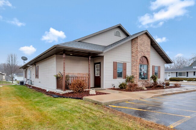


This Property Is For Sale
NEARBY LISTINGS FOR SALE OR LEASE
Property Detail
155 W Menasha Ave
Manitowoc, WI
Certified Surv
039-500-000-084.11
1408-60 VILLAGE OF WHITELAW ASSESSORS PLAT TRACT 14.2 CSM V15 P225 BEING RESRVY OF TRACT 14 CSM V10 P637 BEING PRT OF LOT 84
Commercialnec
Manitowoc
X
Wisconsin
55071C0165D
84
2024
0.44 AC
2024
Wisconsin South Area
010400
Other Market Areas
DEMOGRAPHICS near 155 W Menasha Ave
1 Mile
3 Mile
5 Mile
2024 Total Population
847
2,126
4,191
2029 Population
835
2,100
4,151
Pop Growth 2024-2029
(1.42%)
(1.22%)
(0.95%)
Average Age
43
44
44
2024 Total Households
349
877
1,735
HH Growth 2024-2029
(1.43%)
(1.25%)
(1.04%)
Median Household Inc
$74,749
$73,124
$72,800
Avg Household Size
2.40
2.40
2.40
2024 Avg HH Vehicles
2.00
2.00
2.00
Median Home Value
$185,525
$192,977
$203,398
Median Year Built
1971
1971
1971
Nearby Places
Map Layers
Map Styles
 Street
 Aerial
- Restaurants
- Banks
- Shops
- Fitness
- Groceries
PUBLIC TRANSPORTATION
AIRPORT
Green Bay/Austin Straubel International
DRIVE
WALK
Distance
Green Bay/Austin Straubel International
51 min
40.5 mi
Freight Ports
Port Milwaukee
DRIVE
WALK
Distance
Port Milwaukee
106 min
90.5 mi
Nearby Properties
Address
Land Use
TOTAL SIZE
Lot Size
Zoning
Address
Land Use
TOTAL SIZE
Lot Size
Zoning
5 AC
A1
Address
Land Use
TOTAL SIZE
Lot Size
Zoning
5.21 AC
A1
Address
Land Use
TOTAL SIZE
Lot Size
Zoning
5.02 AC
A1
Address
Land Use
TOTAL SIZE
Lot Size
Zoning
0.72 AC
Address
Land Use
TOTAL SIZE
Lot Size
Zoning
0.71 AC
Address
Land Use
TOTAL SIZE
Lot Size
Zoning
Address
Land Use
TOTAL SIZE
Lot Size
Zoning
38.40 AC
A3
Address
Land Use
TOTAL SIZE
Lot Size
Zoning
0.42 AC
Address
Land Use
TOTAL SIZE
Lot Size
Zoning
Address
Land Use
TOTAL SIZE
Lot Size
Zoning
1.47 AC
Address
Land Use
TOTAL SIZE
Lot Size
Zoning
0.65 AC
Address
Land Use
TOTAL SIZE
Lot Size
Zoning
2.01 AC
B1
Address
Land Use
TOTAL SIZE
Lot Size
Zoning
Address
Land Use
TOTAL SIZE
Lot Size
Zoning
0.46 AC
Address
Land Use
TOTAL SIZE
Lot Size
Zoning
0.40 AC
Address
Land Use
TOTAL SIZE
Lot Size
Zoning
0.97 AC
Address
Land Use
TOTAL SIZE
Lot Size
Zoning
0.38 AC
Address
Land Use
TOTAL SIZE
Lot Size
Zoning
28.62 AC
A3
Address
Land Use
TOTAL SIZE
Lot Size
Zoning
44.02 AC
A3
Address
Land Use
TOTAL SIZE
Lot Size
Zoning
Address
Land Use
TOTAL SIZE
Lot Size
Zoning
0.38 AC
Address
Land Use
TOTAL SIZE
Lot Size
Zoning
40.02 AC
NA
Address
Land Use
TOTAL SIZE
Lot Size
Zoning
1.06 AC
B1
Address
Land Use
TOTAL SIZE
Lot Size
Zoning
0.40 AC
Address
Land Use
TOTAL SIZE
Lot Size
Zoning
2.39 AC
Address
Land Use
TOTAL SIZE
Lot Size
Zoning
2.63 AC
A1
Address
Land Use
TOTAL SIZE
Lot Size
Zoning
0.18 AC
Address
Land Use
TOTAL SIZE
Lot Size
Zoning
0.45 AC
Address
Land Use
TOTAL SIZE
Lot Size
Zoning
38.87 AC
A3
The World's #1 Commercial Real Estate Marketplace
Connect with us
© 2025 CoStar Group
The information above has been obtained from sources believed reliable. While we do not doubt its accuracy we have not verified it and make no guarantee, warranty or representation about it. It is your responsibility to independently confirm its accuracy and completeness. Any projections, opinions, assumptions, or estimates used are for example only and do not represent the current or future performance of the property. The value of this transaction to you depends on tax and other factors which should be evaluated by your tax, financial, and legal advisors. You and your advisors should conduct a careful, independent investigation of the property to determine to your satisfaction the suitability of the property for your needs.