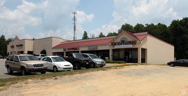
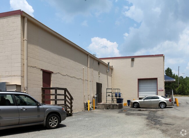
Property Record
1432 E Dixie Dr, Asheboro, NC 27203

NEARBY LISTINGS FOR SALE OR LEASE
Property Detail
1432 E Dixie Dr
7761-70-3645
Alta Acsm Land Title Survey For Rcc Vill
Stripcommercialcenter
R64;S (VILLAGE MARKETPLACE OF ASHEBORO LP) PL:38-8
X
Randolph
3710776100J
North Carolina
2025
8.56 AC
2025
SE Randolph County
030806
Greensboro/Winston-Salem
38,113 SF
Greensboro-High Point, NC
DEMOGRAPHICS near 1432 E Dixie Dr
1 Mile
3 Mile
5 Mile
2024 Total Population
1,826
21,789
42,523
2029 Population
1,897
22,687
44,258
Pop Growth 2024-2029
+ 3.89%
+ 4.12%
+ 4.08%
Average Age
40
40
40
2024 Total Households
684
8,646
16,887
HH Growth 2024-2029
+ 3.80%
+ 4.16%
+ 4.06%
Median Household Inc
$38,156
$41,955
$47,529
Avg Household Size
2.50
2.40
2.40
2024 Avg HH Vehicles
2.00
2.00
2.00
Median Home Value
$136,480
$136,875
$141,058
Median Year Built
1972
1972
1979
Nearby Places
Map Layers
Map Styles
 Street
 Aerial
- Restaurants
- Banks
- Shops
- Fitness
- Groceries
PUBLIC TRANSPORTATION
AIRPORT
Piedmont Triad International
DRIVE
WALK
Distance
Piedmont Triad International
49 min
35.1 mi
Freight Ports
Port of Wilmington
DRIVE
WALK
Distance
Port of Wilmington
227 min
190.7 mi
SALE & LEASE HISTORY
LISTING DATE
SALE/LEASE

Sep 25, 2016
For Lease
Dec 22, 2016
For Lease
Nearby Properties
Address
Land Use
TOTAL SIZE
Lot Size
Zoning
Address
Land Use
TOTAL SIZE
Lot Size
Zoning
312,205 SF
6.83 AC
B2
Address
Land Use
TOTAL SIZE
Lot Size
Zoning
221,524 SF
22.11 AC
B2 (CZ)
Address
Land Use
TOTAL SIZE
Lot Size
Zoning
178,413 SF
36.13 AC
B2
Address
Land Use
TOTAL SIZE
Lot Size
Zoning
178,413 SF
35.87 AC
B2
Address
Land Use
TOTAL SIZE
Lot Size
Zoning
24.92 AC
B2
Address
Land Use
TOTAL SIZE
Lot Size
Zoning
5.24 AC
B3
Address
Land Use
TOTAL SIZE
Lot Size
Zoning
75,251 SF
18.75 AC
B2 (CZ)
Address
Land Use
TOTAL SIZE
Lot Size
Zoning
84,857 SF
8.31 AC
B2
Address
Land Use
TOTAL SIZE
Lot Size
Zoning
84,329 SF
71.50 AC
I2
Address
Land Use
TOTAL SIZE
Lot Size
Zoning
29,212 SF
104.58 AC
B2
Address
Land Use
TOTAL SIZE
Lot Size
Zoning
84,298 SF
8.25 AC
B2
Address
Land Use
TOTAL SIZE
Lot Size
Zoning
94,956 SF
15.15 AC
B2
Address
Land Use
TOTAL SIZE
Lot Size
Zoning
52,741 SF
2.53 AC
B2
Address
Land Use
TOTAL SIZE
Lot Size
Zoning
83,900 SF
8.22 AC
B2
Address
Land Use
TOTAL SIZE
Lot Size
Zoning
52,741 SF
2.15 AC
B2
Address
Land Use
TOTAL SIZE
Lot Size
Zoning
136,877 SF
25.59 AC
I1
Address
Land Use
TOTAL SIZE
Lot Size
Zoning
193,214 SF
17.06 AC
I1
Address
Land Use
TOTAL SIZE
Lot Size
Zoning
38,113 SF
8.16 AC
B2
Address
Land Use
TOTAL SIZE
Lot Size
Zoning
53,871 SF
11.36 AC
B2
Address
Land Use
TOTAL SIZE
Lot Size
Zoning
35,502 SF
2.83 AC
B2
Address
Land Use
TOTAL SIZE
Lot Size
Zoning
4,590 SF
15.50 AC
RA6
Address
Land Use
TOTAL SIZE
Lot Size
Zoning
18,144 SF
2.91 AC
B2
Address
Land Use
TOTAL SIZE
Lot Size
Zoning
47,797 SF
2.61 AC
B2 (CZ)
Address
Land Use
TOTAL SIZE
Lot Size
Zoning
14,800 SF
6.03 AC
I1
Address
Land Use
TOTAL SIZE
Lot Size
Zoning
5.58 AC
B2
Address
Land Use
TOTAL SIZE
Lot Size
Zoning
43,046 SF
4.09 AC
B2
Address
Land Use
TOTAL SIZE
Lot Size
Zoning
59,830 SF
0.85 AC
RA6
Address
Land Use
TOTAL SIZE
Lot Size
Zoning
75,024 SF
2.02 AC
B2
Address
Land Use
TOTAL SIZE
Lot Size
Zoning
8,614 SF
7.40 AC
RA6
The World's #1 Commercial Real Estate Marketplace
Connect with us
© 2026 CoStar Group
The information above has been obtained from sources believed reliable. While we do not doubt its accuracy we have not verified it and make no guarantee, warranty or representation about it. It is your responsibility to independently confirm its accuracy and completeness. Any projections, opinions, assumptions, or estimates used are for example only and do not represent the current or future performance of the property. The value of this transaction to you depends on tax and other factors which should be evaluated by your tax, financial, and legal advisors. You and your advisors should conduct a careful, independent investigation of the property to determine to your satisfaction the suitability of the property for your needs.