Property Record
1620 Robert Crain Hwy N, Bowie, MD 20716
This Property Is For Sale
NEARBY LISTINGS FOR SALE OR LEASE
Property Detail
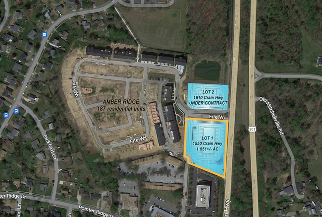
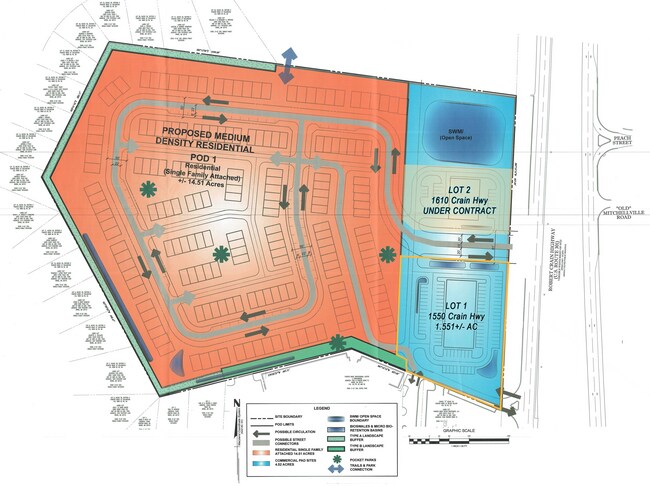
1620 Robert Crain Hwy N
Washington, DC
Plat Five Parcels A C 1 & 2 Amber Ridge
Washington-Arlington-Alexandria, DC-VA-MD-WV
Prince George's
07-5680415
Maryland
Townhouserowhouse
0.99 AC
X
Bowie
24033C0190E
DEMOGRAPHICS near 1620 Robert Crain Hwy N
1 Mile
3 Mile
5 Mile
2024 Total Population
5,741
32,018
82,446
2029 Population
5,634
31,109
80,236
Pop Growth 2024-2029
(1.86%)
(2.84%)
(2.68%)
Average Age
43
43
43
2024 Total Households
2,101
11,911
29,251
HH Growth 2024-2029
(2.05%)
(2.96%)
(2.80%)
Median Household Inc
$123,124
$127,191
$135,144
Avg Household Size
2.60
2.60
2.80
2024 Avg HH Vehicles
2.00
2.00
2.00
Median Home Value
$363,160
$419,783
$446,326
Median Year Built
1978
1990
1990
Nearby Places
- Restaurants
- Banks
- Shops
- Fitness
- Groceries
PUBLIC TRANSPORTATION
COMMUTER RAIL
Bowie State Marc Sb (PENN - WASHINGTON - Maryland Transit Administration)
DRIVE
WALK
Distance
Bowie State Marc Sb (PENN - WASHINGTON - Maryland Transit Administration)
16 min
9.4 mi
Bowie State Marc Nb (PENN - WASHINGTON - Maryland Transit Administration)
DRIVE
WALK
Distance
Bowie State Marc Nb (PENN - WASHINGTON - Maryland Transit Administration)
17 min
9.4 mi
AIRPORT
Ronald Reagan Washington Ntl
DRIVE
WALK
Distance
Ronald Reagan Washington Ntl
37 min
23.1 mi
Baltimore/Washington International Thurgood Marshall
DRIVE
WALK
Distance
Baltimore/Washington International Thurgood Marshall
38 min
24.9 mi
Freight Ports
Port of Baltimore
DRIVE
WALK
Distance
Port of Baltimore
45 min
30.5 mi
Nearby Properties
Address
Land Use
TOTAL SIZE
Lot Size
Zoning
Address
Land Use
TOTAL SIZE
Lot Size
Zoning
278,982 SF
22.25 AC
LCD
Address
Land Use
TOTAL SIZE
Lot Size
Zoning
15.34 AC
LCD
Address
Land Use
TOTAL SIZE
Lot Size
Zoning
286 SF
13.08 AC
RMF20
Address
Land Use
TOTAL SIZE
Lot Size
Zoning
338 SF
20.94 AC
RMF20
Address
Land Use
TOTAL SIZE
Lot Size
Zoning
15.87 AC
LCD
Address
Land Use
TOTAL SIZE
Lot Size
Zoning
283,176 SF
30.51 AC
TACC
Address
Land Use
TOTAL SIZE
Lot Size
Zoning
123,000 SF
36.77 AC
AR
Address
Land Use
TOTAL SIZE
Lot Size
Zoning
290,919 SF
28.01 AC
IH
Address
Land Use
TOTAL SIZE
Lot Size
Zoning
170,850 SF
28.43 AC
IH
Address
Land Use
TOTAL SIZE
Lot Size
Zoning
79,939 SF
6.17 AC
LCD
Address
Land Use
TOTAL SIZE
Lot Size
Zoning
133,694 SF
9.46 AC
CS
Address
Land Use
TOTAL SIZE
Lot Size
Zoning
75,927 SF
265.61 AC
AR
Address
Land Use
TOTAL SIZE
Lot Size
Zoning
378,068 SF
24.35 AC
IH
Address
Land Use
TOTAL SIZE
Lot Size
Zoning
392,581 SF
27.85 AC
IH
Address
Land Use
TOTAL SIZE
Lot Size
Zoning
124,313 SF
12.70 AC
CGO
Address
Land Use
TOTAL SIZE
Lot Size
Zoning
111,009 SF
11.43 AC
CGO
Address
Land Use
TOTAL SIZE
Lot Size
Zoning
222,152 SF
11.89 AC
IH
Address
Land Use
TOTAL SIZE
Lot Size
Zoning
242,331 SF
19.71 AC
IH
Address
Land Use
TOTAL SIZE
Lot Size
Zoning
140 SF
5.47 AC
RMF20
Address
Land Use
TOTAL SIZE
Lot Size
Zoning
124,984 SF
10.30 AC
TACE
Address
Land Use
TOTAL SIZE
Lot Size
Zoning
117,622 SF
10.93 AC
CS
Address
Land Use
TOTAL SIZE
Lot Size
Zoning
188,751 SF
9.81 AC
IH
Address
Land Use
TOTAL SIZE
Lot Size
Zoning
65,928 SF
6.61 AC
TACC
Address
Land Use
TOTAL SIZE
Lot Size
Zoning
159,876 SF
13.62 AC
TACC
Address
Land Use
TOTAL SIZE
Lot Size
Zoning
169,840 SF
9.81 AC
IH
Address
Land Use
TOTAL SIZE
Lot Size
Zoning
116,798 SF
12.80 AC
CGO
Address
Land Use
TOTAL SIZE
Lot Size
Zoning
60,600 SF
6 AC
RR
Address
Land Use
TOTAL SIZE
Lot Size
Zoning
129,800 SF
3.13 AC
TACE
Address
Land Use
TOTAL SIZE
Lot Size
Zoning
125,731 SF
12.35 AC
TACE
Address
Land Use
TOTAL SIZE
Lot Size
Zoning
104,000 SF
3.30 AC
TACC
The World's #1 Commercial Real Estate Marketplace
Connect with us
© 2025 CoStar Group
The information above has been obtained from sources believed reliable. While we do not doubt its accuracy we have not verified it and make no guarantee, warranty or representation about it. It is your responsibility to independently confirm its accuracy and completeness. Any projections, opinions, assumptions, or estimates used are for example only and do not represent the current or future performance of the property. The value of this transaction to you depends on tax and other factors which should be evaluated by your tax, financial, and legal advisors. You and your advisors should conduct a careful, independent investigation of the property to determine to your satisfaction the suitability of the property for your needs.