Property Record
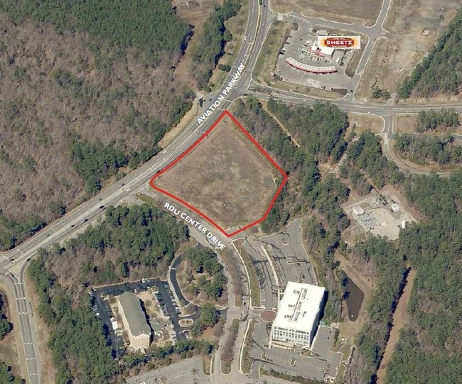
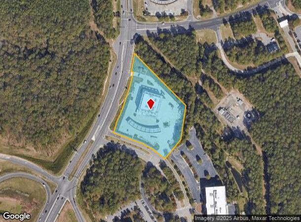
1550 Aviation Pkwy, Morrisville, NC 27560
NEARBY LISTINGS FOR SALE OR LEASE
Property Detail
1550 Aviation Pkwy
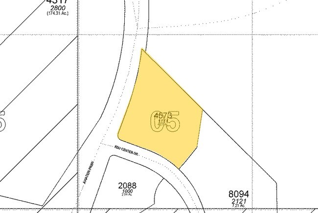
0766.01-05-4573-000
Rdu Center
Officebuilding
RDU CENTER TRA BM2008-00160
X
Wake
3720076600K
North Carolina
2024
3.96 AC
2025
RTP/RDU
980100
Raleigh/Durham
38,269 SF
Raleigh, NC
DEMOGRAPHICS near 1550 Aviation Pkwy
1 Mile
3 Mile
5 Mile
2024 Total Population
0
24,661
145,785
2029 Population
0
27,166
158,291
Pop Growth 2024-2029
0.00%
+ 10.16%
+ 8.58%
Average Age
0
36
37
2024 Total Households
0
10,590
62,641
HH Growth 2024-2029
0.00%
+ 10.11%
+ 8.53%
Median Household Inc
$0
$96,935
$99,908
Avg Household Size
.00
2.30
2.30
2024 Avg HH Vehicles
.00
2.00
2.00
Median Home Value
$0
$429,866
$421,411
Median Year Built
0
2005
2002
Nearby Places
Map Layers
Map Styles
 Street
 Aerial
- Restaurants
- Banks
- Shops
- Fitness
- Groceries
PUBLIC TRANSPORTATION
COMMUTER RAIL
Cary Station (Piedmont - North Carolina by Train (NC Train))
DRIVE
WALK
Distance
Cary Station (Piedmont - North Carolina by Train (NC Train))
10 min
6.5 mi
AIRPORT
Raleigh-Durham International
DRIVE
WALK
Distance
Raleigh-Durham International
6 min
2.4 mi
Freight Ports
Port of Wilmington
DRIVE
WALK
Distance
Port of Wilmington
166 min
145.9 mi
SALE & LEASE HISTORY
LISTING DATE
SALE/LEASE

Sep 24, 2016
For Sale
Nearby Properties
Address
Land Use
TOTAL SIZE
Lot Size
Zoning
Address
Land Use
TOTAL SIZE
Lot Size
Zoning
3,672,648 SF
4,584.26 AC
AD-2
Address
Land Use
TOTAL SIZE
Lot Size
Zoning
24,907 SF
5,245.45 AC
R-4
Address
Land Use
TOTAL SIZE
Lot Size
Zoning
237,537 SF
24.60 AC
C-BAC
Address
Land Use
TOTAL SIZE
Lot Size
Zoning
949,404 SF
26.71 AC
OIP
Address
Land Use
TOTAL SIZE
Lot Size
Zoning
8,418 SF
22.17 AC
MU(D)
Address
Land Use
TOTAL SIZE
Lot Size
Zoning
312,475 SF
21.74 AC
RMFP
Address
Land Use
TOTAL SIZE
Lot Size
Zoning
312,088 SF
12.53 AC
BAC-G
Address
Land Use
TOTAL SIZE
Lot Size
Zoning
554,316 SF
42.79 AC
ORD
Address
Land Use
TOTAL SIZE
Lot Size
Zoning
358,137 SF
22.39 AC
RMFP
Address
Land Use
TOTAL SIZE
Lot Size
Zoning
300,662 SF
12.68 AC
BAC-G
Address
Land Use
TOTAL SIZE
Lot Size
Zoning
414,214 SF
11.23 AC
OIP
Address
Land Use
TOTAL SIZE
Lot Size
Zoning
444,236 SF
8.51 AC
ORDP
Address
Land Use
TOTAL SIZE
Lot Size
Zoning
408,968 SF
32.58 AC
HDR
Address
Land Use
TOTAL SIZE
Lot Size
Zoning
266,419 SF
77.78 AC
RA
Address
Land Use
TOTAL SIZE
Lot Size
Zoning
172,116 SF
56.06 AC
C-OI
Address
Land Use
TOTAL SIZE
Lot Size
Zoning
513,738 SF
35.66 AC
OIP
Address
Land Use
TOTAL SIZE
Lot Size
Zoning
261,061 SF
18.75 AC
HDR
Address
Land Use
TOTAL SIZE
Lot Size
Zoning
298,457 SF
35.55 AC
RAC
Address
Land Use
TOTAL SIZE
Lot Size
Zoning
370,540 SF
20.79 AC
PD
Address
Land Use
TOTAL SIZE
Lot Size
Zoning
407,178 SF
22.57 AC
PD
Address
Land Use
TOTAL SIZE
Lot Size
Zoning
463,340 SF
12.38 AC
OI
Address
Land Use
TOTAL SIZE
Lot Size
Zoning
579,364 SF
32.23 AC
IM
Address
Land Use
TOTAL SIZE
Lot Size
Zoning
272,508 SF
15.49 AC
NAC
Address
Land Use
TOTAL SIZE
Lot Size
Zoning
230,165 SF
10.39 AC
OI
Address
Land Use
TOTAL SIZE
Lot Size
Zoning
12,468 SF
20.97 AC
MU(D)
Address
Land Use
TOTAL SIZE
Lot Size
Zoning
312,240 SF
24.05 AC
OI
Address
Land Use
TOTAL SIZE
Lot Size
Zoning
293,944 SF
8.89 AC
RMFP
Address
Land Use
TOTAL SIZE
Lot Size
Zoning
283,799 SF
32.70 AC
RMFP
Address
Land Use
TOTAL SIZE
Lot Size
Zoning
298,349 SF
15.92 AC
RAC
Address
Land Use
TOTAL SIZE
Lot Size
Zoning
424,070 SF
13.43 AC
OIP
The World's #1 Commercial Real Estate Marketplace
Connect with us
© 2025 CoStar Group
The information above has been obtained from sources believed reliable. While we do not doubt its accuracy we have not verified it and make no guarantee, warranty or representation about it. It is your responsibility to independently confirm its accuracy and completeness. Any projections, opinions, assumptions, or estimates used are for example only and do not represent the current or future performance of the property. The value of this transaction to you depends on tax and other factors which should be evaluated by your tax, financial, and legal advisors. You and your advisors should conduct a careful, independent investigation of the property to determine to your satisfaction the suitability of the property for your needs.