Property Record
1550 Central Ave, Riverside, CA 92507
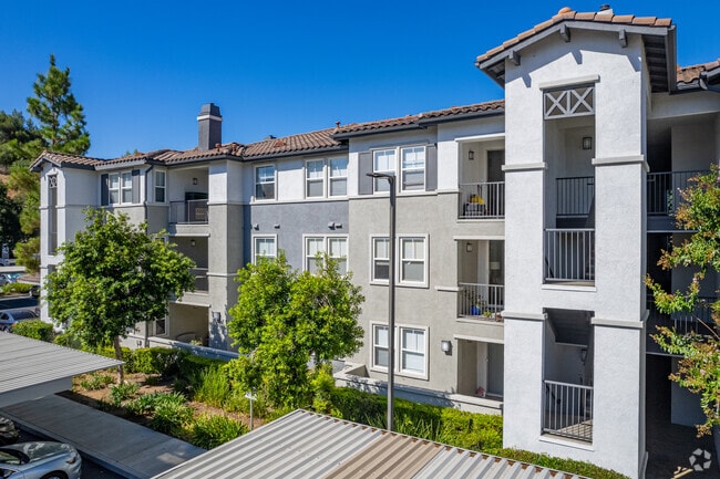

Property Detail
1550 Central Ave
Riverside-San Bernardino-Ontario, CA
4.89 ACRES M/L IN POR LOT 6 MB 006/084 MARTIN & ORMAND TR
254-070-022
Riverside
Apartment
California
B and X Area of moderate flood hazard, usually the area between the limits of the 100-year and 500-year floods.
6
2024
4.89 AC
2025
Canyon Crest
042207
Inland Empire (California)
108,930 SF
NEARBY LISTINGS FOR SALE OR LEASE
DEMOGRAPHICS near 1550 Central Ave
1 mile
3 mile
5 mile
2025 Total Population
10,392
101,353
236,956
2030 Population
10,620
103,836
242,501
Pop Growth 2025-2030
+ 2.19%
+ 2.45%
+ 2.34%
Average Age
39
36
36
2025 Total Households
3,731
32,703
72,185
HH Growth 2025-2030
+ 1.69%
+ 2.03%
+ 1.93%
Median Household Inc
$109,155
$85,384
$92,566
Avg Household Size
2.60
2.70
3.00
2025 Avg HH Vehicles
2.00
2.00
2.00
Median Home Value
$751,834
$681,362
$649,489
Median Year Built
1973
1976
1978
Nearby Places
Map Layers
Map Styles
 Street
 Aerial
Transit
 Traffic
 Biking
Places
Listings with unknown addresses are not visible on the map
- Restaurants
- Banks
- Shops
- Fitness
- Groceries
PUBLIC TRANSPORTATION
COMMUTER RAIL
Riverside-Downtown (91 Line - Southern California Regional Rail Authority (Metrolink), Inland Empire-Orange County Line - Southern California Regional Rail Authority (Metrolink), Riverside Line - Southern California Regional Rail Authority (Metrolink))
Drive
Walk
Distance
Riverside-Downtown (91 Line - Southern California Regional Rail Authority (Metrolink), Inland Empire-Orange County Line - Southern California Regional Rail Authority (Metrolink), Riverside Line - Southern California Regional Rail Authority (Metrolink))
6 min
2.7 mi
Drive
Walk
Distance
7 min
3.7 mi
AIRPORT
Ontario International
Drive
Walk
Distance
Ontario International
28 min
20.5 mi
Nearby Properties
Address
Land Use
TOTAL SIZE
Lot Size
Zoning
Address
Land Use
TOTAL SIZE
Lot Size
Zoning
412,950 SF
23.16 AC
C2
Address
Land Use
TOTAL SIZE
Lot Size
Zoning
1,012,995 SF
47.62 AC
Address
Land Use
TOTAL SIZE
Lot Size
Zoning
361,346 SF
18.17 AC
Address
Land Use
TOTAL SIZE
Lot Size
Zoning
247,416 SF
10.17 AC
Address
Land Use
TOTAL SIZE
Lot Size
Zoning
95,047 SF
10.25 AC
Address
Land Use
TOTAL SIZE
Lot Size
Zoning
350,278 SF
1.21 AC
Address
Land Use
TOTAL SIZE
Lot Size
Zoning
449,040 SF
18.86 AC
BMP
Address
Land Use
TOTAL SIZE
Lot Size
Zoning
126,036 SF
30.90 AC
Address
Land Use
TOTAL SIZE
Lot Size
Zoning
26,879 SF
16.27 AC
R3
Address
Land Use
TOTAL SIZE
Lot Size
Zoning
217,036 SF
1.66 AC
C2
Address
Land Use
TOTAL SIZE
Lot Size
Zoning
Address
Land Use
TOTAL SIZE
Lot Size
Zoning
156,241 SF
2.55 AC
Address
Land Use
TOTAL SIZE
Lot Size
Zoning
209,734 SF
10.87 AC
R3
Address
Land Use
TOTAL SIZE
Lot Size
Zoning
139,454 SF
0.97 AC
DSP
Address
Land Use
TOTAL SIZE
Lot Size
Zoning
37,729 SF
3.23 AC
Address
Land Use
TOTAL SIZE
Lot Size
Zoning
36,010 SF
11.76 AC
R3
Address
Land Use
TOTAL SIZE
Lot Size
Zoning
663,613 SF
44.28 AC
Address
Land Use
TOTAL SIZE
Lot Size
Zoning
87,600 SF
0.39 AC
Address
Land Use
TOTAL SIZE
Lot Size
Zoning
16.39 AC
R3
Address
Land Use
TOTAL SIZE
Lot Size
Zoning
134,474 SF
7.99 AC
C2
Address
Land Use
TOTAL SIZE
Lot Size
Zoning
253,025 SF
15.62 AC
R3
Address
Land Use
TOTAL SIZE
Lot Size
Zoning
509,422 SF
36.94 AC
Address
Land Use
TOTAL SIZE
Lot Size
Zoning
134,944 SF
2.52 AC
Address
Land Use
TOTAL SIZE
Lot Size
Zoning
415,990 SF
5.16 AC
Address
Land Use
TOTAL SIZE
Lot Size
Zoning
459,463 SF
17.38 AC
Address
Land Use
TOTAL SIZE
Lot Size
Zoning
129,739 SF
5.08 AC
Address
Land Use
TOTAL SIZE
Lot Size
Zoning
28,548 SF
12.44 AC
The World's #1 Commercial Real Estate Marketplace
Connect with us
© 2026 CoStar Group
The information above has been obtained from sources believed reliable. While we do not doubt its accuracy we have not verified it and make no guarantee, warranty or representation about it. It is your responsibility to independently confirm its accuracy and completeness. Any projections, opinions, assumptions, or estimates used are for example only and do not represent the current or future performance of the property. The value of this transaction to you depends on tax and other factors which should be evaluated by your tax, financial, and legal advisors. You and your advisors should conduct a careful, independent investigation of the property to determine to your satisfaction the suitability of the property for your needs.