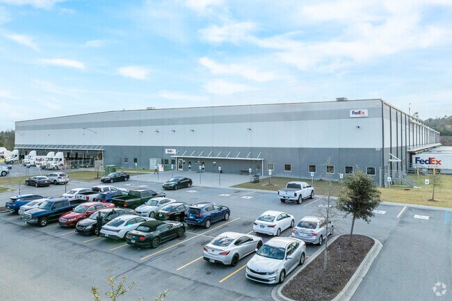
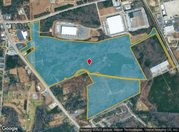
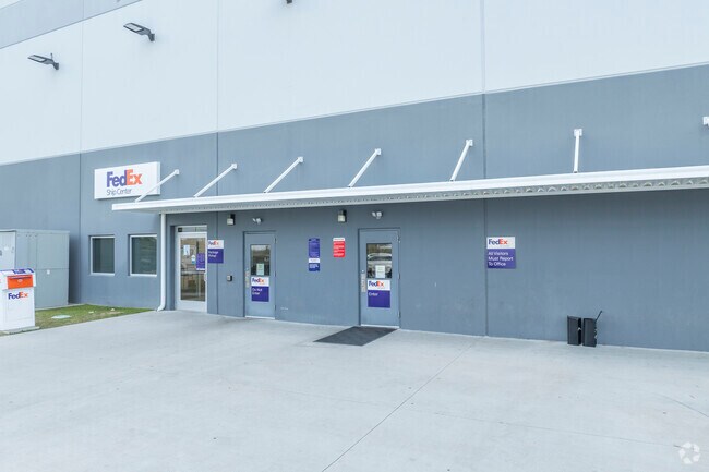
Property Record
1550 Four H Club Rd, Augusta, GA 30906
NEARBY LISTINGS FOR SALE OR LEASE
Property Detail
1550 Four H Club Rd
Augusta-Richmond County, GA-SC
Powell And Barrett
1580006070
TRACT 3
Agriculturalland
Richmond
X
Georgia
13245C0230H
281.26 AC
2025
South Richmond County
2025
Augusta/Richmond County
010509
DEMOGRAPHICS near 1550 Four H Club Rd
1 Mile
3 Mile
5 Mile
2024 Total Population
1,678
13,479
41,915
2029 Population
1,673
13,405
41,541
Pop Growth 2024-2029
(0.30%)
(0.55%)
(0.89%)
Average Age
36
37
38
2024 Total Households
636
4,704
15,529
HH Growth 2024-2029
(0.31%)
(0.62%)
(0.85%)
Median Household Inc
$58,048
$43,820
$47,539
Avg Household Size
2.50
2.60
2.60
2024 Avg HH Vehicles
2.00
2.00
2.00
Median Home Value
$135,465
$122,347
$115,998
Median Year Built
1995
1984
1977
Nearby Places
Map Layers
Map Styles
 Street
 Aerial
- Restaurants
- Banks
- Shops
- Fitness
- Groceries
PUBLIC TRANSPORTATION
AIRPORT
Augusta Regional at Bush Field
DRIVE
WALK
Distance
Augusta Regional at Bush Field
13 min
4.3 mi
Freight Ports
Georgia Ports - Savannah
DRIVE
WALK
Distance
Georgia Ports - Savannah
142 min
109.0 mi
Nearby Properties
Address
Land Use
TOTAL SIZE
Lot Size
Zoning
Address
Land Use
TOTAL SIZE
Lot Size
Zoning
297,455 SF
45.93 AC
A
Address
Land Use
TOTAL SIZE
Lot Size
Zoning
78,943 SF
1,319.60 AC
HI
Address
Land Use
TOTAL SIZE
Lot Size
Zoning
193,026 SF
97.24 AC
R-1
Address
Land Use
TOTAL SIZE
Lot Size
Zoning
39,200 SF
310.85 AC
A_R-1A
Address
Land Use
TOTAL SIZE
Lot Size
Zoning
87,976 SF
765.88 AC
R-1
Address
Land Use
TOTAL SIZE
Lot Size
Zoning
449,636 SF
31.57 AC
Address
Land Use
TOTAL SIZE
Lot Size
Zoning
225,664 SF
57.13 AC
LI
Address
Land Use
TOTAL SIZE
Lot Size
Zoning
3,387 SF
16.91 AC
B-2
Address
Land Use
TOTAL SIZE
Lot Size
Zoning
552,852 SF
215.52 AC
A_HI
Address
Land Use
TOTAL SIZE
Lot Size
Zoning
14,850 SF
132.49 AC
A,R
Address
Land Use
TOTAL SIZE
Lot Size
Zoning
18,000 SF
27.80 AC
B-2
Address
Land Use
TOTAL SIZE
Lot Size
Zoning
403,560 SF
27.99 AC
HI_LI
Address
Land Use
TOTAL SIZE
Lot Size
Zoning
23,184 SF
6.88 AC
R-3C
Address
Land Use
TOTAL SIZE
Lot Size
Zoning
403,560 SF
27.99 AC
HI_LI
Address
Land Use
TOTAL SIZE
Lot Size
Zoning
4,356 SF
52.76 AC
A_R-MH_B-2
Address
Land Use
TOTAL SIZE
Lot Size
Zoning
298,532 SF
20.39 AC
HI
Address
Land Use
TOTAL SIZE
Lot Size
Zoning
443,388 SF
38.88 AC
HI
Address
Land Use
TOTAL SIZE
Lot Size
Zoning
66,320 SF
14.69 AC
R-1_R-1A
Address
Land Use
TOTAL SIZE
Lot Size
Zoning
62,379 SF
73.78 AC
HI
Address
Land Use
TOTAL SIZE
Lot Size
Zoning
305,990 SF
28.25 AC
HI
Address
Land Use
TOTAL SIZE
Lot Size
Zoning
126,323 SF
5.75 AC
HI
Address
Land Use
TOTAL SIZE
Lot Size
Zoning
33,024 SF
10.64 AC
R-3B
Address
Land Use
TOTAL SIZE
Lot Size
Zoning
437,452 SF
26.15 AC
HI
Address
Land Use
TOTAL SIZE
Lot Size
Zoning
720 SF
37.27 AC
HI
Address
Land Use
TOTAL SIZE
Lot Size
Zoning
127,476 SF
10.19 AC
HI
Address
Land Use
TOTAL SIZE
Lot Size
Zoning
10,575 SF
61.57 AC
HI
Address
Land Use
TOTAL SIZE
Lot Size
Zoning
12,430 SF
58.24 AC
HI
Address
Land Use
TOTAL SIZE
Lot Size
Zoning
437,452 SF
26.15 AC
HI
Address
Land Use
TOTAL SIZE
Lot Size
Zoning
Address
Land Use
TOTAL SIZE
Lot Size
Zoning
56,038 SF
8.01 AC
B-2
The World's #1 Commercial Real Estate Marketplace
Connect with us
© 2026 CoStar Group
The information above has been obtained from sources believed reliable. While we do not doubt its accuracy we have not verified it and make no guarantee, warranty or representation about it. It is your responsibility to independently confirm its accuracy and completeness. Any projections, opinions, assumptions, or estimates used are for example only and do not represent the current or future performance of the property. The value of this transaction to you depends on tax and other factors which should be evaluated by your tax, financial, and legal advisors. You and your advisors should conduct a careful, independent investigation of the property to determine to your satisfaction the suitability of the property for your needs.