Property Record
1550 Highway 23 E, Saint Cloud, MN 56304
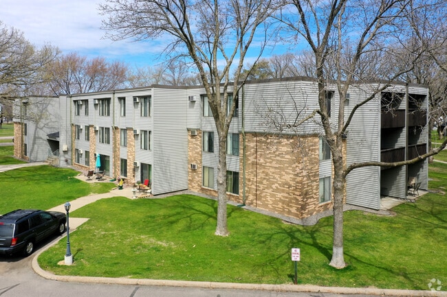
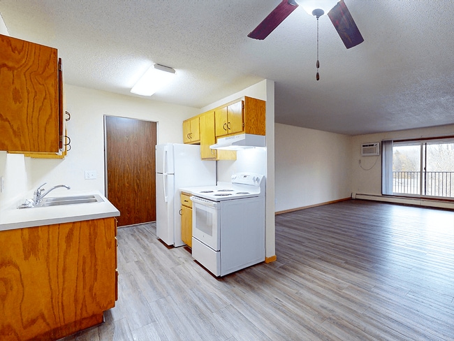
Property Detail
1550 Highway 23 E
St. Cloud, MN
SECT-31 TWP-036 RANGE-030 4.24 AC EAST ST CLOUD UNPLATTED PT OF NW1/4 LESS EASMNT
17.00060.00
Benton
Multifamilydwelling
Minnesota
B and X Area of moderate flood hazard, usually the area between the limits of the 100-year and 500-year floods.
4.24 AC
2025
Outlying Benton County
2025
Minneapolis/St Paul
021201
NEARBY LISTINGS FOR SALE OR LEASE
DEMOGRAPHICS near 1550 Highway 23 E
1 mile
3 mile
5 mile
2025 Total Population
5,725
51,431
92,300
2030 Population
5,799
52,962
95,195
Pop Growth 2025-2030
+ 1.29%
+ 2.98%
+ 3.14%
Average Age
35
35
37
2025 Total Households
2,551
19,822
36,612
HH Growth 2025-2030
+ 1.37%
+ 3.03%
+ 3.17%
Median Household Inc
$47,187
$56,854
$61,657
Avg Household Size
2.20
2.30
2.30
2025 Avg HH Vehicles
1.00
2.00
2.00
Median Home Value
$204,340
$203,360
$240,103
Median Year Built
1977
1974
1982
Nearby Places
Map Layers
Map Styles
 Street
 Aerial
Layers
 Traffic
 Biking
Places
Listings with unknown addresses are not visible on the map
- Restaurants
- Banks
- Shops
- Fitness
- Groceries
PUBLIC TRANSPORTATION
COMMUTER RAIL
St. Cloud Amtrak Station (Empire Builder - Amtrak)
Drive
Walk
Distance
St. Cloud Amtrak Station (Empire Builder - Amtrak)
3 min
1.3 mi
Freight Ports
Port Milwaukee
Drive
Walk
Distance
Port Milwaukee
450 min
402.5 mi
Nearby Properties
Address
Land Use
TOTAL SIZE
Lot Size
Zoning
Address
Land Use
TOTAL SIZE
Lot Size
Zoning
16.60 AC
MD
Address
Land Use
TOTAL SIZE
Lot Size
Zoning
362,000 SF
86.20 AC
Address
Land Use
TOTAL SIZE
Lot Size
Zoning
154.73 AC
I
Address
Land Use
TOTAL SIZE
Lot Size
Zoning
107,306 SF
2.11 AC
C4
Address
Land Use
TOTAL SIZE
Lot Size
Zoning
105,833 SF
4.61 AC
C4
Address
Land Use
TOTAL SIZE
Lot Size
Zoning
157,266 SF
0.94 AC
R2
Address
Land Use
TOTAL SIZE
Lot Size
Zoning
238,920 SF
5.40 AC
R3
Address
Land Use
TOTAL SIZE
Lot Size
Zoning
Address
Land Use
TOTAL SIZE
Lot Size
Zoning
281,127 SF
3.10 AC
PUD95
Address
Land Use
TOTAL SIZE
Lot Size
Zoning
15.77 AC
Address
Land Use
TOTAL SIZE
Lot Size
Zoning
365,299 SF
28.68 AC
R1
Address
Land Use
TOTAL SIZE
Lot Size
Zoning
252,469 SF
35 AC
Address
Land Use
TOTAL SIZE
Lot Size
Zoning
177,951 SF
8.26 AC
R3
Address
Land Use
TOTAL SIZE
Lot Size
Zoning
152,055 SF
2.33 AC
R3
Address
Land Use
TOTAL SIZE
Lot Size
Zoning
165,758 SF
3 AC
R3
Address
Land Use
TOTAL SIZE
Lot Size
Zoning
Address
Land Use
TOTAL SIZE
Lot Size
Zoning
158,809 SF
2.67 AC
R3
Address
Land Use
TOTAL SIZE
Lot Size
Zoning
232,274 SF
2.94 AC
R3
Address
Land Use
TOTAL SIZE
Lot Size
Zoning
157,500 SF
1.25 AC
C3
Address
Land Use
TOTAL SIZE
Lot Size
Zoning
24.47 AC
Address
Land Use
TOTAL SIZE
Lot Size
Zoning
105,123 SF
36.87 AC
R1
Address
Land Use
TOTAL SIZE
Lot Size
Zoning
Address
Land Use
TOTAL SIZE
Lot Size
Zoning
127,460 SF
5 AC
Address
Land Use
TOTAL SIZE
Lot Size
Zoning
183,627 SF
3 AC
R3
Address
Land Use
TOTAL SIZE
Lot Size
Zoning
6.61 AC
Address
Land Use
TOTAL SIZE
Lot Size
Zoning
25,608 SF
6.96 AC
R5
Address
Land Use
TOTAL SIZE
Lot Size
Zoning
0.28 AC
I2
Address
Land Use
TOTAL SIZE
Lot Size
Zoning
100,024 SF
0.47 AC
Address
Land Use
TOTAL SIZE
Lot Size
Zoning
Address
Land Use
TOTAL SIZE
Lot Size
Zoning
72,200 SF
3 AC
R3
The World's #1 Commercial Real Estate Marketplace
Connect with us
© 2026 CoStar Group
The information above has been obtained from sources believed reliable. While we do not doubt its accuracy we have not verified it and make no guarantee, warranty or representation about it. It is your responsibility to independently confirm its accuracy and completeness. Any projections, opinions, assumptions, or estimates used are for example only and do not represent the current or future performance of the property. The value of this transaction to you depends on tax and other factors which should be evaluated by your tax, financial, and legal advisors. You and your advisors should conduct a careful, independent investigation of the property to determine to your satisfaction the suitability of the property for your needs.