Property Record
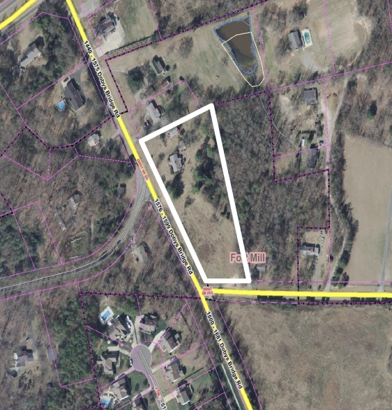
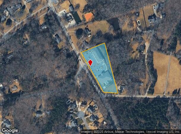
1550 N Dobys Bridge Rd, Fort Mill, SC 29715
NEARBY LISTINGS FOR SALE OR LEASE
-
-
-
-
-
No Photo
-
View all Fort Mill listings for sale on LoopNet.com
Property Detail
1550 N Dobys Bridge Rd
0201701062
Dobys Bridge
Realpropertynec
3.087 AC TUPELO BUSINESS PARK CONDO ID PARCEL
X
York
45091C0331F
South Carolina
0
3.09 AC
2025
York County
061104
Charlotte
10,000 SF
Charlotte-Concord-Gastonia, NC-SC
DEMOGRAPHICS near 1550 N Dobys Bridge Rd
1 Mile
3 Mile
5 Mile
2024 Total Population
5,243
31,576
101,341
2029 Population
5,916
36,162
115,996
Pop Growth 2024-2029
+ 12.84%
+ 14.52%
+ 14.46%
Average Age
37
37
37
2024 Total Households
1,791
11,318
38,079
HH Growth 2024-2029
+ 13.12%
+ 14.72%
+ 14.64%
Median Household Inc
$112,089
$107,720
$96,781
Avg Household Size
2.90
2.80
2.60
2024 Avg HH Vehicles
2.00
2.00
2.00
Median Home Value
$358,620
$380,944
$370,755
Median Year Built
2003
2004
2006
Nearby Places
Map Layers
Map Styles
 Street
 Aerial
- Restaurants
- Banks
- Shops
- Fitness
- Groceries
PUBLIC TRANSPORTATION
AIRPORT
Charlotte/Douglas International
DRIVE
WALK
Distance
Charlotte/Douglas International
34 min
18.8 mi
Concord-Padgett Regional
DRIVE
WALK
Distance
Concord-Padgett Regional
52 min
35.8 mi
Freight Ports
North Charleston Terminal
DRIVE
WALK
Distance
North Charleston Terminal
210 min
184.7 mi
SALE & LEASE HISTORY
LISTING DATE
SALE/LEASE

Sep 24, 2016
For Sale
Nearby Properties
Address
Land Use
TOTAL SIZE
Lot Size
Zoning
Address
Land Use
TOTAL SIZE
Lot Size
Zoning
64,338 SF
0.83 AC
Address
Land Use
TOTAL SIZE
Lot Size
Zoning
178,585 SF
17.44 AC
Address
Land Use
TOTAL SIZE
Lot Size
Zoning
167.49 AC
MULTIPLEZ
Address
Land Use
TOTAL SIZE
Lot Size
Zoning
162.78 AC
RCI
Address
Land Use
TOTAL SIZE
Lot Size
Zoning
64,113 SF
6.69 AC
Address
Land Use
TOTAL SIZE
Lot Size
Zoning
197,864 SF
39.37 AC
Address
Land Use
TOTAL SIZE
Lot Size
Zoning
79,600 SF
9.58 AC
Address
Land Use
TOTAL SIZE
Lot Size
Zoning
7,772 SF
4.75 AC
Address
Land Use
TOTAL SIZE
Lot Size
Zoning
598,425 SF
102 AC
ID
Address
Land Use
TOTAL SIZE
Lot Size
Zoning
28,569 SF
0.39 AC
Address
Land Use
TOTAL SIZE
Lot Size
Zoning
Address
Land Use
TOTAL SIZE
Lot Size
Zoning
18,990 SF
0.23 AC
Address
Land Use
TOTAL SIZE
Lot Size
Zoning
131,716 SF
13.89 AC
Address
Land Use
TOTAL SIZE
Lot Size
Zoning
21,761 SF
30.22 AC
AGC
Address
Land Use
TOTAL SIZE
Lot Size
Zoning
532,223 SF
29.11 AC
LI
Address
Land Use
TOTAL SIZE
Lot Size
Zoning
16.05 AC
Address
Land Use
TOTAL SIZE
Lot Size
Zoning
5,392 SF
1 AC
Address
Land Use
TOTAL SIZE
Lot Size
Zoning
4,953 SF
2.20 AC
Address
Land Use
TOTAL SIZE
Lot Size
Zoning
4,698 SF
3.30 AC
Address
Land Use
TOTAL SIZE
Lot Size
Zoning
5,289 SF
1.20 AC
PD
Address
Land Use
TOTAL SIZE
Lot Size
Zoning
5,800 SF
2.41 AC
RCI
Address
Land Use
TOTAL SIZE
Lot Size
Zoning
4,358 SF
0.23 AC
Address
Land Use
TOTAL SIZE
Lot Size
Zoning
8,320 SF
1.89 AC
PDD
Address
Land Use
TOTAL SIZE
Lot Size
Zoning
3,763 SF
2 AC
Address
Land Use
TOTAL SIZE
Lot Size
Zoning
3,831 SF
1 AC
Address
Land Use
TOTAL SIZE
Lot Size
Zoning
8,777 SF
58.12 AC
Address
Land Use
TOTAL SIZE
Lot Size
Zoning
4,731 SF
1 AC
RCI
Address
Land Use
TOTAL SIZE
Lot Size
Zoning
259.17 AC
Address
Land Use
TOTAL SIZE
Lot Size
Zoning
2,894 SF
0.76 AC
The World's #1 Commercial Real Estate Marketplace
Connect with us
© 2025 CoStar Group
The information above has been obtained from sources believed reliable. While we do not doubt its accuracy we have not verified it and make no guarantee, warranty or representation about it. It is your responsibility to independently confirm its accuracy and completeness. Any projections, opinions, assumptions, or estimates used are for example only and do not represent the current or future performance of the property. The value of this transaction to you depends on tax and other factors which should be evaluated by your tax, financial, and legal advisors. You and your advisors should conduct a careful, independent investigation of the property to determine to your satisfaction the suitability of the property for your needs.