Property Record
1550 Progress Rd, Springfield, OH 45505
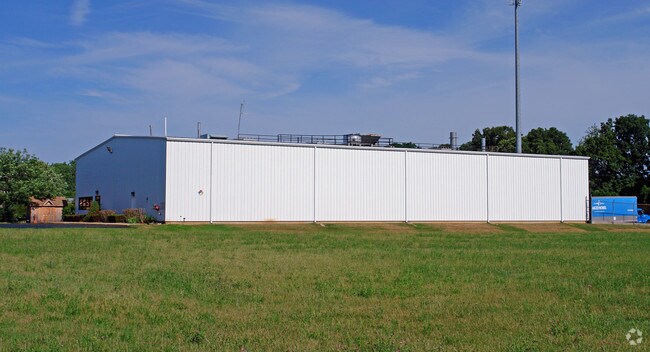

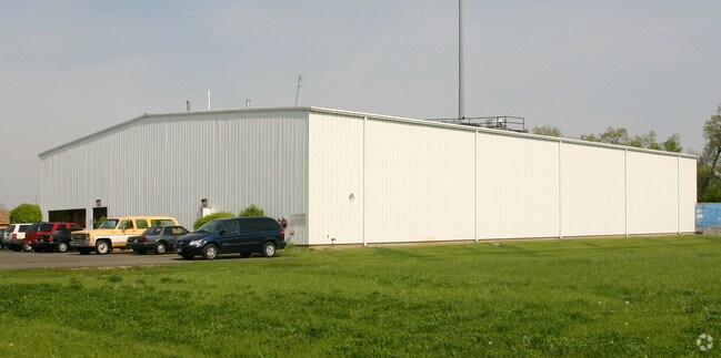
Property Detail
1550 Progress Rd
Springfield, OH
SPRINGFIELD INDUSTRIAL PARK SECTION 1 5
33-00700-02740-6006
Clark
Lightindustrial
Ohio
B and X Area of moderate flood hazard, usually the area between the limits of the 100-year and 500-year floods.
6
2024
2.08 AC
2025
Northeast Dayton
001300
Cincinnati/Dayton
17,000 SF
NEARBY LISTINGS FOR SALE OR LEASE
DEMOGRAPHICS near 1550 Progress Rd
1 mile
3 mile
5 mile
2025 Total Population
5,388
47,365
73,744
2030 Population
5,383
47,863
74,018
Pop Growth 2025-2030
(0.09%)
+ 1.05%
+ 0.37%
Average Age
38
38
40
2025 Total Households
2,256
18,892
30,411
HH Growth 2025-2030
(0.09%)
+ 1.04%
+ 0.33%
Median Household Inc
$44,959
$43,691
$50,425
Avg Household Size
2.30
2.30
2.30
2025 Avg HH Vehicles
2.00
2.00
2.00
Median Home Value
$89,782
$108,003
$149,401
Median Year Built
1950
1948
1954
Nearby Places
Map Layers
Map Styles
 Street
 Aerial
Transit
 Traffic
 Biking
Places
Listings with unknown addresses are not visible on the map
- Restaurants
- Banks
- Shops
- Fitness
- Groceries
PUBLIC TRANSPORTATION
AIRPORT
James M Cox Dayton International
Drive
Walk
Distance
James M Cox Dayton International
36 min
27.2 mi
Freight Ports
Port of Toledo
Drive
Walk
Distance
Port of Toledo
193 min
136.6 mi
SALE & LEASE HISTORY
LISTING DATE
SALE/LEASE

Mar 21, 2025
For Sale
Nearby Properties
Address
Land Use
TOTAL SIZE
Lot Size
Zoning
Address
Land Use
TOTAL SIZE
Lot Size
Zoning
479,515 SF
1.69 AC
Address
Land Use
TOTAL SIZE
Lot Size
Zoning
399,308 SF
11.06 AC
Address
Land Use
TOTAL SIZE
Lot Size
Zoning
44.85 AC
Address
Land Use
TOTAL SIZE
Lot Size
Zoning
103,458 SF
5.51 AC
Address
Land Use
TOTAL SIZE
Lot Size
Zoning
12,657 SF
8.17 AC
Address
Land Use
TOTAL SIZE
Lot Size
Zoning
399,308 SF
11.06 AC
Address
Land Use
TOTAL SIZE
Lot Size
Zoning
8,316 SF
34.41 AC
R-1
Address
Land Use
TOTAL SIZE
Lot Size
Zoning
4,644 SF
100.91 AC
Address
Land Use
TOTAL SIZE
Lot Size
Zoning
47,929 SF
2.77 AC
Address
Land Use
TOTAL SIZE
Lot Size
Zoning
Address
Land Use
TOTAL SIZE
Lot Size
Zoning
199,566 SF
109.96 AC
Address
Land Use
TOTAL SIZE
Lot Size
Zoning
56,381 SF
2.37 AC
Address
Land Use
TOTAL SIZE
Lot Size
Zoning
Address
Land Use
TOTAL SIZE
Lot Size
Zoning
Address
Land Use
TOTAL SIZE
Lot Size
Zoning
Address
Land Use
TOTAL SIZE
Lot Size
Zoning
32,566 SF
1.90 AC
Address
Land Use
TOTAL SIZE
Lot Size
Zoning
217,626 SF
17.85 AC
Address
Land Use
TOTAL SIZE
Lot Size
Zoning
Address
Land Use
TOTAL SIZE
Lot Size
Zoning
399,308 SF
31.78 AC
Address
Land Use
TOTAL SIZE
Lot Size
Zoning
1.05 AC
Address
Land Use
TOTAL SIZE
Lot Size
Zoning
Address
Land Use
TOTAL SIZE
Lot Size
Zoning
Address
Land Use
TOTAL SIZE
Lot Size
Zoning
77,006 SF
1.39 AC
Address
Land Use
TOTAL SIZE
Lot Size
Zoning
74,122 SF
3.39 AC
Address
Land Use
TOTAL SIZE
Lot Size
Zoning
Address
Land Use
TOTAL SIZE
Lot Size
Zoning
26.78 AC
Address
Land Use
TOTAL SIZE
Lot Size
Zoning
50,170 SF
7.09 AC
Address
Land Use
TOTAL SIZE
Lot Size
Zoning
13,500 SF
27.70 AC
A
Address
Land Use
TOTAL SIZE
Lot Size
Zoning
65,272 SF
2.33 AC
Address
Land Use
TOTAL SIZE
Lot Size
Zoning
5.64 AC
The World's #1 Commercial Real Estate Marketplace
Connect with us
© 2026 CoStar Group
The information above has been obtained from sources believed reliable. While we do not doubt its accuracy we have not verified it and make no guarantee, warranty or representation about it. It is your responsibility to independently confirm its accuracy and completeness. Any projections, opinions, assumptions, or estimates used are for example only and do not represent the current or future performance of the property. The value of this transaction to you depends on tax and other factors which should be evaluated by your tax, financial, and legal advisors. You and your advisors should conduct a careful, independent investigation of the property to determine to your satisfaction the suitability of the property for your needs.