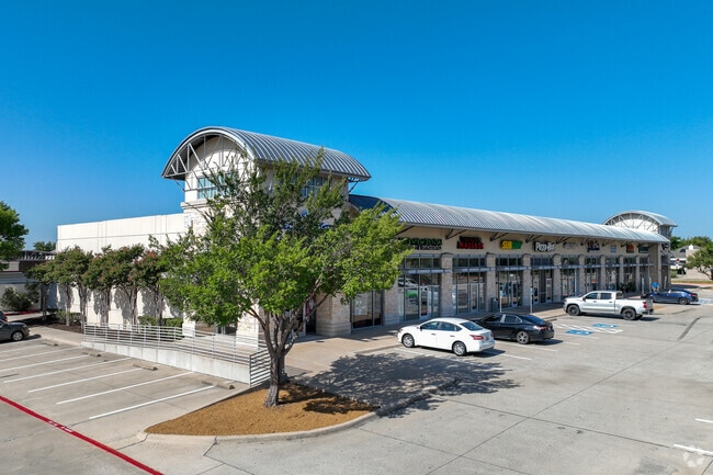
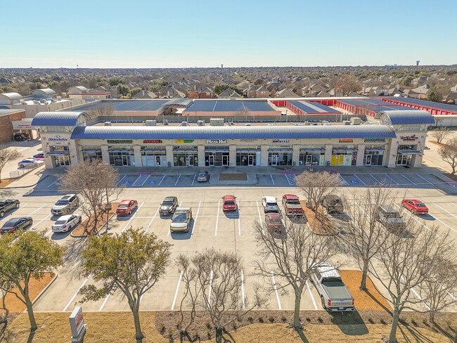
Property Record
1550 Stacy Rd, Allen, TX 75002

Property Detail
1550 Stacy Rd
Dallas-Fort Worth-Arlington, TX
LOST CREEK VILLAGE ADDITION, BLK 1, LOT 1
R-5066-001-0010-1
COLLIN
Commercialnec
Texas
B and X Area of moderate flood hazard, usually the area between the limits of the 100-year and 500-year floods.
1
2025
1.94 AC
2025
Allen
031413
Dallas/Ft Worth
17,973 SF
NEARBY LISTINGS FOR SALE OR LEASE
DEMOGRAPHICS near 1550 Stacy Rd
1 mile
3 mile
5 mile
2024 Total Population
11,759
77,176
223,635
2029 Population
13,309
87,785
254,987
Pop Growth 2024-2029
+ 13.18%
+ 13.75%
+ 14.02%
Average Age
38
40
39
2024 Total Households
3,739
27,310
80,695
HH Growth 2024-2029
+ 13.51%
+ 13.97%
+ 14.33%
Median Household Inc
$139,999
$116,729
$117,867
Avg Household Size
3.10
2.80
2.70
2024 Avg HH Vehicles
2.00
2.00
2.00
Median Home Value
$551,842
$491,506
$532,172
Median Year Built
2006
2004
2004
Nearby Places
Map Layers
Map Styles
 Street
 Aerial
Transit
 Traffic
 Biking
Places
Listings with unknown addresses are not visible on the map
- Restaurants
- Banks
- Shops
- Fitness
- Groceries
PUBLIC TRANSPORTATION
AIRPORT
Dallas Love Field
Drive
Walk
Distance
Dallas Love Field
40 min
30.2 mi
Dallas-Fort Worth International
Drive
Walk
Distance
Dallas-Fort Worth International
42 min
33.9 mi
SALE & LEASE HISTORY
LISTING DATE
SALE/LEASE

Sep 25, 2016
For Lease
May 04, 2021
For Sale
Jul 16, 2025
For Lease
Jan 23, 2025
For Sale
Dec 06, 2018
For Lease
Nearby Properties
Address
Land Use
TOTAL SIZE
Lot Size
Zoning
Address
Land Use
TOTAL SIZE
Lot Size
Zoning
1,089,284 SF
90.69 AC
Address
Land Use
TOTAL SIZE
Lot Size
Zoning
638,539 SF
42.76 AC
Address
Land Use
TOTAL SIZE
Lot Size
Zoning
472,185 SF
63.51 AC
AO
Address
Land Use
TOTAL SIZE
Lot Size
Zoning
611,780 SF
59.06 AC
L1
Address
Land Use
TOTAL SIZE
Lot Size
Zoning
720,571 SF
68.28 AC
Address
Land Use
TOTAL SIZE
Lot Size
Zoning
709,804 SF
32.68 AC
Address
Land Use
TOTAL SIZE
Lot Size
Zoning
162,000 SF
34 AC
L1
Address
Land Use
TOTAL SIZE
Lot Size
Zoning
495,048 SF
7.37 AC
Address
Land Use
TOTAL SIZE
Lot Size
Zoning
288,826 SF
18.71 AC
CC
Address
Land Use
TOTAL SIZE
Lot Size
Zoning
586,110 SF
10.50 AC
LI
Address
Land Use
TOTAL SIZE
Lot Size
Zoning
414,198 SF
72.67 AC
Address
Land Use
TOTAL SIZE
Lot Size
Zoning
350,018 SF
7.02 AC
MF-E
Address
Land Use
TOTAL SIZE
Lot Size
Zoning
370,860 SF
25.48 AC
Address
Land Use
TOTAL SIZE
Lot Size
Zoning
260,340 SF
18.64 AC
RG-18
Address
Land Use
TOTAL SIZE
Lot Size
Zoning
382,360 SF
68.99 AC
Address
Land Use
TOTAL SIZE
Lot Size
Zoning
349,991 SF
13.53 AC
MF-M
Address
Land Use
TOTAL SIZE
Lot Size
Zoning
325,956 SF
17.33 AC
A-0
Address
Land Use
TOTAL SIZE
Lot Size
Zoning
356,096 SF
19.50 AC
MF-M
Address
Land Use
TOTAL SIZE
Lot Size
Zoning
337,121 SF
9.39 AC
Address
Land Use
TOTAL SIZE
Lot Size
Zoning
321,982 SF
22.83 AC
SFR
Address
Land Use
TOTAL SIZE
Lot Size
Zoning
272,853 SF
17.32 AC
PD/ML
Address
Land Use
TOTAL SIZE
Lot Size
Zoning
250,510 SF
14.63 AC
PD-19
Address
Land Use
TOTAL SIZE
Lot Size
Zoning
288,865 SF
23.35 AC
Address
Land Use
TOTAL SIZE
Lot Size
Zoning
281,420 SF
9.43 AC
PD/ML
Address
Land Use
TOTAL SIZE
Lot Size
Zoning
173,393 SF
9.04 AC
MF-M
Address
Land Use
TOTAL SIZE
Lot Size
Zoning
244,257 SF
8.01 AC
AG
Address
Land Use
TOTAL SIZE
Lot Size
Zoning
204,175 SF
10.57 AC
MF-H
Address
Land Use
TOTAL SIZE
Lot Size
Zoning
269,398 SF
6.05 AC
Address
Land Use
TOTAL SIZE
Lot Size
Zoning
307,279 SF
44.15 AC
Address
Land Use
TOTAL SIZE
Lot Size
Zoning
204,080 SF
4 AC
The World's #1 Commercial Real Estate Marketplace
Connect with us
© 2026 CoStar Group
The information above has been obtained from sources believed reliable. While we do not doubt its accuracy we have not verified it and make no guarantee, warranty or representation about it. It is your responsibility to independently confirm its accuracy and completeness. Any projections, opinions, assumptions, or estimates used are for example only and do not represent the current or future performance of the property. The value of this transaction to you depends on tax and other factors which should be evaluated by your tax, financial, and legal advisors. You and your advisors should conduct a careful, independent investigation of the property to determine to your satisfaction the suitability of the property for your needs.