Property Record
15500 51St Ave Ne, Marysville, WA 98271
This Property Is For Sale
NEARBY LISTINGS FOR SALE OR LEASE
Property Detail
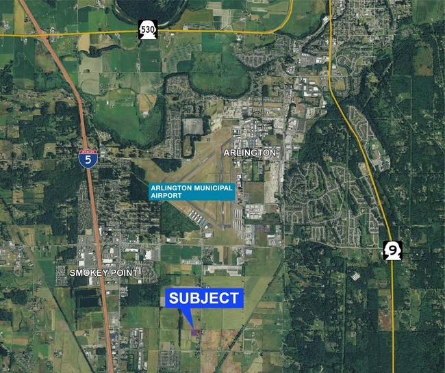
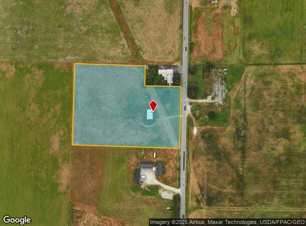
15500 51St Ave Ne
Seattle-Tacoma-Bellevue, WA
Mortons Crossing
310533-001-016-00
SEC 33 TWP 31 RGE 05 BEG NE COR NE1/4 NE1/4 TH N86*54 52W ALGN LN THOF 578.42FT TH S03*06 47W PLW W LN SD NE1/4 NE1/4 740.51FT TO NW COR OF TR CONVYD TO FISHER E HILL & EILEEN F HILL BY CONT REC UNDER AUD FILE NO 7607070060 TH S71*36 01E 402.63FT TH
Miscellaneous
Snohomish
X
Washington
53061C0395E
16
2024
5 AC
2025
N Snohomish County
940001
Seattle/Puget Sound
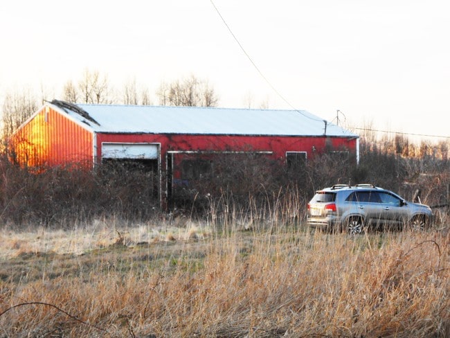
460 SF
DEMOGRAPHICS near 15500 51St Ave Ne
1 Mile
3 Mile
5 Mile
2024 Total Population
3,918
34,363
74,409
2029 Population
4,109
35,868
77,692
Pop Growth 2024-2029
+ 4.87%
+ 4.38%
+ 4.41%
Average Age
37
39
39
2024 Total Households
1,448
12,297
26,914
HH Growth 2024-2029
+ 4.97%
+ 4.48%
+ 4.52%
Median Household Inc
$103,191
$96,288
$95,239
Avg Household Size
2.60
2.70
2.70
2024 Avg HH Vehicles
2.00
2.00
2.00
Median Home Value
$476,785
$490,036
$492,187
Median Year Built
1999
1994
1992
Nearby Places
Map Layers
Map Styles
 Street
 Aerial
- Restaurants
- Banks
- Shops
- Fitness
- Groceries
PUBLIC TRANSPORTATION
AIRPORT
Seattle Paine Field International
DRIVE
WALK
Distance
Seattle Paine Field International
33 min
21.6 mi
Freight Ports
Port of Everett
DRIVE
WALK
Distance
Port of Everett
23 min
14.1 mi
Nearby Properties
Address
Land Use
TOTAL SIZE
Lot Size
Zoning
Address
Land Use
TOTAL SIZE
Lot Size
Zoning
2,623,172 SF
32.78 AC
Address
Land Use
TOTAL SIZE
Lot Size
Zoning
407,929 SF
20.45 AC
R12 MFL
Address
Land Use
TOTAL SIZE
Lot Size
Zoning
543,010 SF
108.29 AC
GI
Address
Land Use
TOTAL SIZE
Lot Size
Zoning
242,217 SF
157.97 AC
AF
Address
Land Use
TOTAL SIZE
Lot Size
Zoning
3.14 AC
IP
Address
Land Use
TOTAL SIZE
Lot Size
Zoning
336,508 SF
23.32 AC
LI
Address
Land Use
TOTAL SIZE
Lot Size
Zoning
121,154 SF
144.64 AC
AF
Address
Land Use
TOTAL SIZE
Lot Size
Zoning
33,140 SF
135.95 AC
BP
Address
Land Use
TOTAL SIZE
Lot Size
Zoning
201,141 SF
7.37 AC
MU
Address
Land Use
TOTAL SIZE
Lot Size
Zoning
229,606 SF
9.28 AC
R18 MFM
Address
Land Use
TOTAL SIZE
Lot Size
Zoning
206,135 SF
4.05 AC
HC
Address
Land Use
TOTAL SIZE
Lot Size
Zoning
1,664 SF
16.93 AC
LI
Address
Land Use
TOTAL SIZE
Lot Size
Zoning
189,663 SF
8.21 AC
MU
Address
Land Use
TOTAL SIZE
Lot Size
Zoning
205,213 SF
8.81 AC
NC
Address
Land Use
TOTAL SIZE
Lot Size
Zoning
231,030 SF
18.48 AC
LI
Address
Land Use
TOTAL SIZE
Lot Size
Zoning
83.67 AC
SQ
Address
Land Use
TOTAL SIZE
Lot Size
Zoning
165,762 SF
7.12 AC
MU
Address
Land Use
TOTAL SIZE
Lot Size
Zoning
186,723 SF
5.36 AC
HC
Address
Land Use
TOTAL SIZE
Lot Size
Zoning
131,319 SF
4.72 AC
MU
Address
Land Use
TOTAL SIZE
Lot Size
Zoning
82.67 AC
R4.5 SFM
Address
Land Use
TOTAL SIZE
Lot Size
Zoning
9.87 AC
R4.5 SFM
Address
Land Use
TOTAL SIZE
Lot Size
Zoning
117,532 SF
4.72 AC
R18 MFM
Address
Land Use
TOTAL SIZE
Lot Size
Zoning
68,424 SF
2.09 AC
HC
Address
Land Use
TOTAL SIZE
Lot Size
Zoning
259,794 SF
12.48 AC
GI
Address
Land Use
TOTAL SIZE
Lot Size
Zoning
46,272 SF
77.08 AC
AF
Address
Land Use
TOTAL SIZE
Lot Size
Zoning
8,581 SF
75.47 AC
LI
Address
Land Use
TOTAL SIZE
Lot Size
Zoning
182,316 SF
15.03 AC
HC
Address
Land Use
TOTAL SIZE
Lot Size
Zoning
70,712 SF
4 AC
GC
Address
Land Use
TOTAL SIZE
Lot Size
Zoning
62,035 SF
58.88 AC
AF
The World's #1 Commercial Real Estate Marketplace
Connect with us
© 2025 CoStar Group
The information above has been obtained from sources believed reliable. While we do not doubt its accuracy we have not verified it and make no guarantee, warranty or representation about it. It is your responsibility to independently confirm its accuracy and completeness. Any projections, opinions, assumptions, or estimates used are for example only and do not represent the current or future performance of the property. The value of this transaction to you depends on tax and other factors which should be evaluated by your tax, financial, and legal advisors. You and your advisors should conduct a careful, independent investigation of the property to determine to your satisfaction the suitability of the property for your needs.