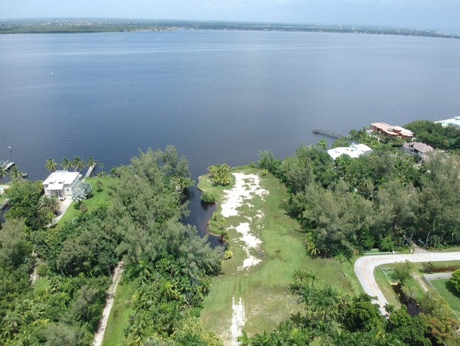
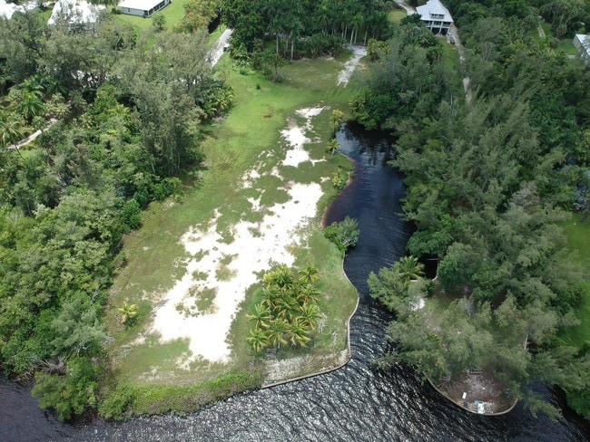
Property Record
15500 Cook Rd, Fort Myers, FL 33908

NEARBY LISTINGS FOR SALE OR LEASE
Property Detail
15500 Cook Rd
Southwest Florida
Iona Riverfront
Cape Coral-Fort Myers, FL
E 330 FT OF N 1/2 OF E 1/2 GOVT LOT 3 PART SWAMP + W 50 FT OF GOVT LT 4
35-45-23-00-00003.0000
Lee
Residentialacreage
Florida
2024
3,4
2025
3.67 AC
001923
S Ft Myers/San Carlos
3,804 SF
DEMOGRAPHICS near 15500 Cook Rd
1 Mile
3 Mile
5 Mile
2024 Total Population
4,205
36,341
108,728
2029 Population
4,961
43,767
130,207
Pop Growth 2024-2029
+ 17.98%
+ 20.43%
+ 19.75%
Average Age
57
59
54
2024 Total Households
2,047
18,417
53,032
HH Growth 2024-2029
+ 17.64%
+ 20.14%
+ 19.45%
Median Household Inc
$62,064
$59,100
$62,133
Avg Household Size
2.00
1.90
2.00
2024 Avg HH Vehicles
1.00
1.00
2.00
Median Home Value
$358,974
$335,216
$311,772
Median Year Built
1990
1990
1990
Nearby Places
Map Layers
Map Styles
 Street
 Aerial
- Restaurants
- Banks
- Shops
- Fitness
- Groceries
PUBLIC TRANSPORTATION
AIRPORT
Southwest Florida International
DRIVE
WALK
Distance
Southwest Florida International
30 min
15.5 mi
Punta Gorda
DRIVE
WALK
Distance
Punta Gorda
58 min
35.1 mi
Freight Ports
Port Manatee
DRIVE
WALK
Distance
Port Manatee
138 min
106.8 mi
SALE & LEASE HISTORY
LISTING DATE
SALE/LEASE

Oct 21, 2019
For Sale
Nearby Properties
Address
Land Use
TOTAL SIZE
Lot Size
Zoning
Address
Land Use
TOTAL SIZE
Lot Size
Zoning
4,442,296 SF
162.17 AC
RM-2
Address
Land Use
TOTAL SIZE
Lot Size
Zoning
446,205 SF
28.90 AC
CC
Address
Land Use
TOTAL SIZE
Lot Size
Zoning
334,148 SF
48.67 AC
RM-2
Address
Land Use
TOTAL SIZE
Lot Size
Zoning
335,660 SF
15.42 AC
MPD
Address
Land Use
TOTAL SIZE
Lot Size
Zoning
744,621 SF
8.01 AC
C1W
Address
Land Use
TOTAL SIZE
Lot Size
Zoning
153,907 SF
22.03 AC
TFC2
Address
Land Use
TOTAL SIZE
Lot Size
Zoning
235,691 SF
30.01 AC
RM-6
Address
Land Use
TOTAL SIZE
Lot Size
Zoning
469,746 SF
89.45 AC
RPD
Address
Land Use
TOTAL SIZE
Lot Size
Zoning
65,051 SF
4.89 AC
CFPD
Address
Land Use
TOTAL SIZE
Lot Size
Zoning
15.22 AC
CF-3
Address
Land Use
TOTAL SIZE
Lot Size
Zoning
84,147 SF
10.60 AC
CPD
Address
Land Use
TOTAL SIZE
Lot Size
Zoning
120,368 SF
3.52 AC
CPD
Address
Land Use
TOTAL SIZE
Lot Size
Zoning
5,654 SF
49.94 AC
MH-2
Address
Land Use
TOTAL SIZE
Lot Size
Zoning
38,928 SF
4.88 AC
CT
Address
Land Use
TOTAL SIZE
Lot Size
Zoning
26,337 SF
11.54 AC
C-1
Address
Land Use
TOTAL SIZE
Lot Size
Zoning
44.05 AC
RPD
Address
Land Use
TOTAL SIZE
Lot Size
Zoning
87,275 SF
10.79 AC
CPD
Address
Land Use
TOTAL SIZE
Lot Size
Zoning
85,815 SF
3.48 AC
CT
Address
Land Use
TOTAL SIZE
Lot Size
Zoning
185,986 SF
13.40 AC
CPD
Address
Land Use
TOTAL SIZE
Lot Size
Zoning
82,450 SF
4.11 AC
CPD
Address
Land Use
TOTAL SIZE
Lot Size
Zoning
59,183 SF
7.16 AC
CPD
Address
Land Use
TOTAL SIZE
Lot Size
Zoning
111,756 SF
2.78 AC
CPD
Address
Land Use
TOTAL SIZE
Lot Size
Zoning
163,409 SF
15.13 AC
CG
Address
Land Use
TOTAL SIZE
Lot Size
Zoning
34,689 SF
6.03 AC
CPD
Address
Land Use
TOTAL SIZE
Lot Size
Zoning
168,737 SF
20.28 AC
CC
Address
Land Use
TOTAL SIZE
Lot Size
Zoning
49,378 SF
2 AC
CPD
Address
Land Use
TOTAL SIZE
Lot Size
Zoning
33,910 SF
3.33 AC
RPD
Address
Land Use
TOTAL SIZE
Lot Size
Zoning
44,117 SF
9.41 AC
CFPD
Address
Land Use
TOTAL SIZE
Lot Size
Zoning
102,031 SF
4.01 AC
MPD
Address
Land Use
TOTAL SIZE
Lot Size
Zoning
61,941 SF
5.95 AC
CC
The World's #1 Commercial Real Estate Marketplace
Connect with us
© 2025 CoStar Group
The information above has been obtained from sources believed reliable. While we do not doubt its accuracy we have not verified it and make no guarantee, warranty or representation about it. It is your responsibility to independently confirm its accuracy and completeness. Any projections, opinions, assumptions, or estimates used are for example only and do not represent the current or future performance of the property. The value of this transaction to you depends on tax and other factors which should be evaluated by your tax, financial, and legal advisors. You and your advisors should conduct a careful, independent investigation of the property to determine to your satisfaction the suitability of the property for your needs.