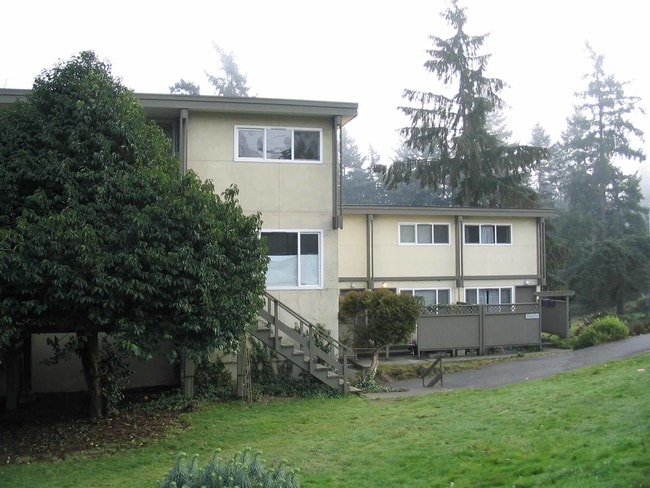
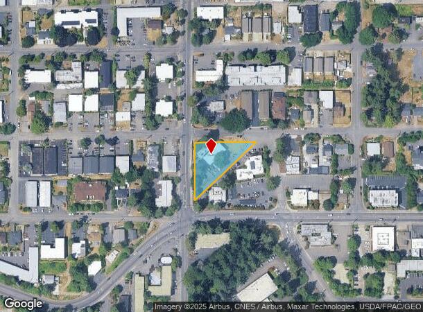
Property Record
15502 4Th Ave Sw, Burien, WA 98166

NEARBY LISTINGS FOR SALE OR LEASE
-
-
-
-
-
No Photo
-
-
-
View all Burien listings for sale on LoopNet.com
Property Detail
15502 4Th Ave Sw
Seattle-Tacoma-Bellevue, WA
Burien Lake View Tracts Div No. 05
122100-0770
BURIEN LAKE VIEW TRS DIV # 5 & POR VAC ST ADJ
Apartment
King
X
Washington
53033C0954G
1-2
2025
0.61 AC
2024
Downtown Burien
027902
Seattle/Puget Sound
10,980 SF
DEMOGRAPHICS near 15502 4Th Ave Sw
1 Mile
3 Mile
5 Mile
2024 Total Population
16,482
89,847
196,450
2029 Population
16,732
90,187
197,239
Pop Growth 2024-2029
+ 1.52%
+ 0.38%
+ 0.40%
Average Age
41
40
40
2024 Total Households
6,738
33,000
73,041
HH Growth 2024-2029
+ 1.32%
+ 0.15%
+ 0.17%
Median Household Inc
$80,973
$84,765
$84,392
Avg Household Size
2.40
2.60
2.60
2024 Avg HH Vehicles
2.00
2.00
2.00
Median Home Value
$697,578
$584,838
$616,550
Median Year Built
1971
1966
1967
Nearby Places
Map Layers
Map Styles
 Street
 Aerial
- Restaurants
- Banks
- Shops
- Fitness
- Groceries
PUBLIC TRANSPORTATION
COMMUTER RAIL
Tukwila Station (Seattle - Tacoma/Lakewood - Sound Transit, Sounder South Line - Sound Transit)
DRIVE
WALK
Distance
Tukwila Station (Seattle - Tacoma/Lakewood - Sound Transit, Sounder South Line - Sound Transit)
9 min
5.6 mi
AIRPORT
Seattle-Tacoma International
DRIVE
WALK
Distance
Seattle-Tacoma International
10 min
4.2 mi
Freight Ports
Port of Seattle
DRIVE
WALK
Distance
Port of Seattle
17 min
9.0 mi
Nearby Properties
Address
Land Use
TOTAL SIZE
Lot Size
Zoning
Address
Land Use
TOTAL SIZE
Lot Size
Zoning
31,032 SF
1,746.88 AC
AVO
Address
Land Use
TOTAL SIZE
Lot Size
Zoning
704,186 SF
21.86 AC
I
Address
Land Use
TOTAL SIZE
Lot Size
Zoning
213,468 SF
23.67 AC
CB-C
Address
Land Use
TOTAL SIZE
Lot Size
Zoning
298,150 SF
9.17 AC
CB-C
Address
Land Use
TOTAL SIZE
Lot Size
Zoning
230,950 SF
6.56 AC
CBP
Address
Land Use
TOTAL SIZE
Lot Size
Zoning
139,868 SF
6.64 AC
O
Address
Land Use
TOTAL SIZE
Lot Size
Zoning
463,722 SF
25.21 AC
RM-18
Address
Land Use
TOTAL SIZE
Lot Size
Zoning
130,200 SF
9.55 AC
CB-C
Address
Land Use
TOTAL SIZE
Lot Size
Zoning
325,494 SF
23.53 AC
AI-2
Address
Land Use
TOTAL SIZE
Lot Size
Zoning
226,771 SF
14.95 AC
CB-C
Address
Land Use
TOTAL SIZE
Lot Size
Zoning
236,919 SF
13.40 AC
AI-1
Address
Land Use
TOTAL SIZE
Lot Size
Zoning
256,409 SF
17.60 AC
RS-7200
Address
Land Use
TOTAL SIZE
Lot Size
Zoning
19,008 SF
12.79 AC
RBX
Address
Land Use
TOTAL SIZE
Lot Size
Zoning
140,000 SF
19.42 AC
UL-7200
Address
Land Use
TOTAL SIZE
Lot Size
Zoning
150,150 SF
9.81 AC
HDR
Address
Land Use
TOTAL SIZE
Lot Size
Zoning
185,925 SF
6.45 AC
RM-24
Address
Land Use
TOTAL SIZE
Lot Size
Zoning
596,532 SF
0.64 AC
CB-C
Address
Land Use
TOTAL SIZE
Lot Size
Zoning
153,668 SF
6.90 AC
RM-24
Address
Land Use
TOTAL SIZE
Lot Size
Zoning
24,240 SF
8 AC
DC
Address
Land Use
TOTAL SIZE
Lot Size
Zoning
132,662 SF
2.38 AC
CB-C
Address
Land Use
TOTAL SIZE
Lot Size
Zoning
125,403 SF
24.64 AC
LDR
Address
Land Use
TOTAL SIZE
Lot Size
Zoning
117,218 SF
7.04 AC
CB-C
Address
Land Use
TOTAL SIZE
Lot Size
Zoning
103,680 SF
3.82 AC
RM-48
Address
Land Use
TOTAL SIZE
Lot Size
Zoning
116,584 SF
5.74 AC
UH-900
Address
Land Use
TOTAL SIZE
Lot Size
Zoning
135,875 SF
9.09 AC
AI-1
Address
Land Use
TOTAL SIZE
Lot Size
Zoning
204,666 SF
2.25 AC
CB-C
Address
Land Use
TOTAL SIZE
Lot Size
Zoning
104,202 SF
5.23 AC
RM-24
Address
Land Use
TOTAL SIZE
Lot Size
Zoning
98,679 SF
1.52 AC
NCC
Address
Land Use
TOTAL SIZE
Lot Size
Zoning
134,724 SF
1.06 AC
CB-C
The World's #1 Commercial Real Estate Marketplace
Connect with us
© 2025 CoStar Group
The information above has been obtained from sources believed reliable. While we do not doubt its accuracy we have not verified it and make no guarantee, warranty or representation about it. It is your responsibility to independently confirm its accuracy and completeness. Any projections, opinions, assumptions, or estimates used are for example only and do not represent the current or future performance of the property. The value of this transaction to you depends on tax and other factors which should be evaluated by your tax, financial, and legal advisors. You and your advisors should conduct a careful, independent investigation of the property to determine to your satisfaction the suitability of the property for your needs.