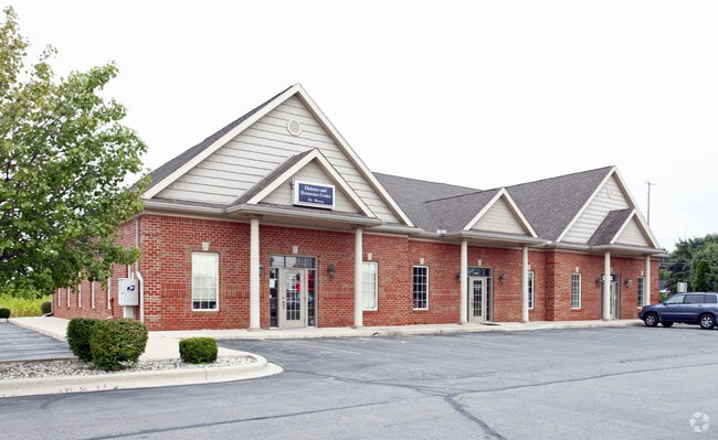
Property Record
15500 S Telegraph Rd, Monroe, MI 48161
NEARBY LISTINGS FOR SALE OR LEASE
Property Detail
15500 S Telegraph Rd
Monroe, MI
Elite Commons Professional Cen
12-020-021-33
Monroe
Condominium
Michigan
X
0.27 AC
26115C0243F
Monroe County
1,396 SF
Detroit
DEMOGRAPHICS near 15500 S Telegraph Rd
1 Mile
3 Mile
5 Mile
2024 Total Population
7,326
37,539
50,848
2029 Population
7,535
38,118
51,645
Pop Growth 2024-2029
+ 2.85%
+ 1.54%
+ 1.57%
Average Age
41
42
42
2024 Total Households
3,041
15,440
20,821
HH Growth 2024-2029
+ 2.70%
+ 1.47%
+ 1.49%
Median Household Inc
$52,988
$56,690
$60,249
Avg Household Size
2.30
2.30
2.30
2024 Avg HH Vehicles
2.00
2.00
2.00
Median Home Value
$142,537
$157,534
$172,378
Median Year Built
1978
1966
1968
Nearby Places
- Restaurants
- Banks
- Shops
- Fitness
- Groceries
PUBLIC TRANSPORTATION
AIRPORT
Detroit Metro Wayne County
DRIVE
WALK
Distance
Detroit Metro Wayne County
33 min
24.9 mi
Eugene F Kranz Toledo Express
DRIVE
WALK
Distance
Eugene F Kranz Toledo Express
60 min
38.7 mi
Freight Ports
Port of Toledo
DRIVE
WALK
Distance
Port of Toledo
35 min
22.9 mi
SALE & LEASE HISTORY
LISTING DATE
SALE/LEASE

Sep 25, 2016
For Lease
Feb 14, 2023
For Lease
Nearby Properties
Address
Land Use
TOTAL SIZE
Lot Size
Zoning
Address
Land Use
TOTAL SIZE
Lot Size
Zoning
97.18 AC
Address
Land Use
TOTAL SIZE
Lot Size
Zoning
200,000 SF
94.63 AC
CO
Address
Land Use
TOTAL SIZE
Lot Size
Zoning
95.60 AC
Address
Land Use
TOTAL SIZE
Lot Size
Zoning
Address
Land Use
TOTAL SIZE
Lot Size
Zoning
109,073 SF
47.32 AC
Address
Land Use
TOTAL SIZE
Lot Size
Zoning
183,508 SF
70 AC
Address
Land Use
TOTAL SIZE
Lot Size
Zoning
3.97 AC
Address
Land Use
TOTAL SIZE
Lot Size
Zoning
13.60 AC
Address
Land Use
TOTAL SIZE
Lot Size
Zoning
108,575 SF
38.21 AC
R-1A
Address
Land Use
TOTAL SIZE
Lot Size
Zoning
43,528 SF
16.06 AC
MHP
Address
Land Use
TOTAL SIZE
Lot Size
Zoning
317,482 SF
20.53 AC
Address
Land Use
TOTAL SIZE
Lot Size
Zoning
2,195 SF
86.71 AC
MHP
Address
Land Use
TOTAL SIZE
Lot Size
Zoning
3,822 SF
16.60 AC
R-1A
Address
Land Use
TOTAL SIZE
Lot Size
Zoning
41 AC
MHP
Address
Land Use
TOTAL SIZE
Lot Size
Zoning
149,282 SF
7.57 AC
R-1A
Address
Land Use
TOTAL SIZE
Lot Size
Zoning
13.38 AC
Address
Land Use
TOTAL SIZE
Lot Size
Zoning
6.78 AC
Address
Land Use
TOTAL SIZE
Lot Size
Zoning
975 SF
34.50 AC
MHP
Address
Land Use
TOTAL SIZE
Lot Size
Zoning
85,062 SF
9.32 AC
Address
Land Use
TOTAL SIZE
Lot Size
Zoning
59,326 SF
6.21 AC
Address
Land Use
TOTAL SIZE
Lot Size
Zoning
106,200 SF
10.83 AC
R-1A
Address
Land Use
TOTAL SIZE
Lot Size
Zoning
37,210 SF
0.57 AC
R-1A
Address
Land Use
TOTAL SIZE
Lot Size
Zoning
66,154 SF
6.22 AC
Address
Land Use
TOTAL SIZE
Lot Size
Zoning
16.65 AC
Address
Land Use
TOTAL SIZE
Lot Size
Zoning
88,848 SF
5.74 AC
Address
Land Use
TOTAL SIZE
Lot Size
Zoning
104,117 SF
12.04 AC
Address
Land Use
TOTAL SIZE
Lot Size
Zoning
88,131 SF
10.18 AC
R-1A
Address
Land Use
TOTAL SIZE
Lot Size
Zoning
48,117 SF
8.13 AC
R-1A
Address
Land Use
TOTAL SIZE
Lot Size
Zoning
38,011 SF
4.02 AC
R-1A
Address
Land Use
TOTAL SIZE
Lot Size
Zoning
34,620 SF
3.85 AC
The World's #1 Commercial Real Estate Marketplace
Connect with us
© 2025 CoStar Group
The information above has been obtained from sources believed reliable. While we do not doubt its accuracy we have not verified it and make no guarantee, warranty or representation about it. It is your responsibility to independently confirm its accuracy and completeness. Any projections, opinions, assumptions, or estimates used are for example only and do not represent the current or future performance of the property. The value of this transaction to you depends on tax and other factors which should be evaluated by your tax, financial, and legal advisors. You and your advisors should conduct a careful, independent investigation of the property to determine to your satisfaction the suitability of the property for your needs.