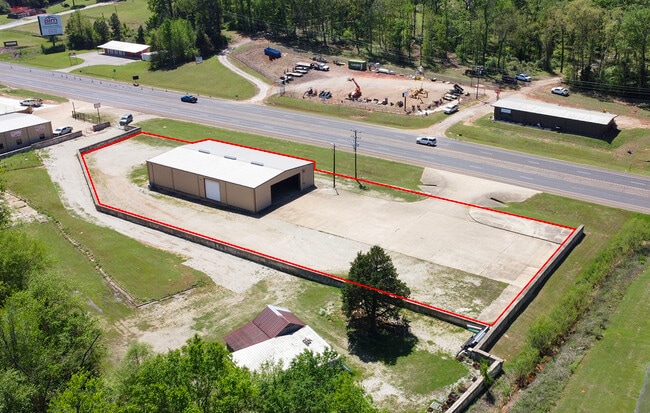
Property Record
15503 State Highway 110 S, Whitehouse, TX 75791


Current Lease Availabilities
Property Detail
15503 State Highway 110 S
1-00000-0755-00-017000
ABST A0755 T ORR ABST A0755 T ORR ABST A0755 T ORR TRACT 17.1 &17A -PT 6.006AC / SEE A-858 TR 1C TRACT 17 TRACT 17B WAS
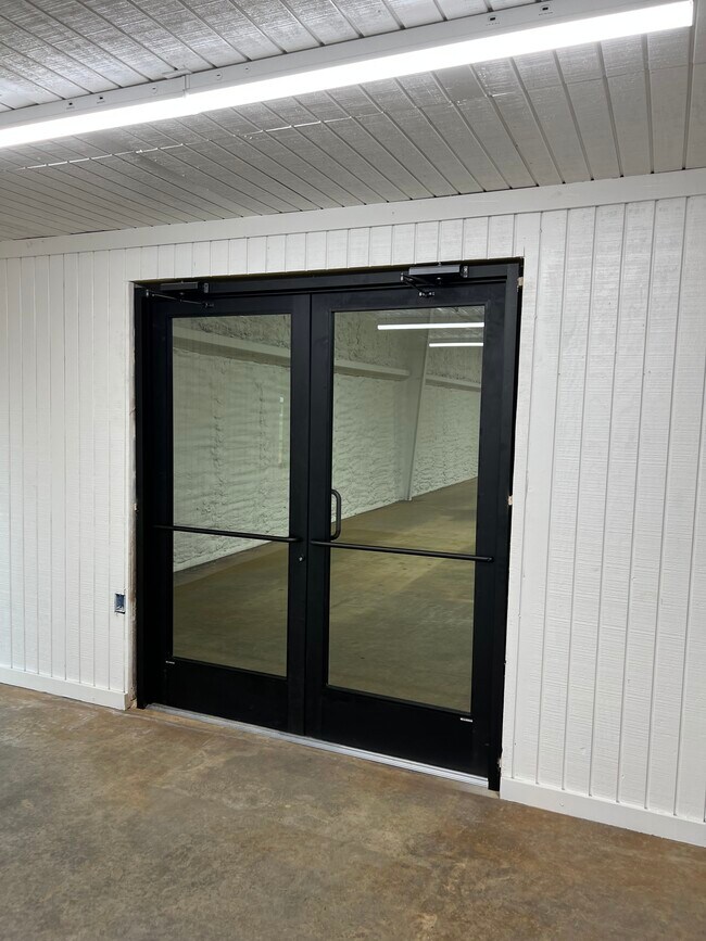
Warehouse
SMITH
AE The base floodplain where base flood elevations are provided. AE Zones are now used on new format FIRMs instead of A1-A30 Zones.
Texas
2025
12.84 AC
2025
Tyler
002009
Other Market Areas
1,500 SF
Tyler, TX
NEARBY LISTINGS FOR SALE OR LEASE
DEMOGRAPHICS near 15503 State Highway 110 S
1 mile
3 mile
5 mile
2025 Total Population
303
15,726
61,149
2030 Population
319
16,595
64,589
Pop Growth 2025-2030
+ 5.28%
+ 5.53%
+ 5.63%
Average Age
38
39
39
2025 Total Households
108
5,686
24,504
HH Growth 2025-2030
+ 5.56%
+ 5.03%
+ 5.17%
Median Household Inc
$65,625
$87,833
$80,732
Avg Household Size
2.70
2.70
2.40
2025 Avg HH Vehicles
2.00
2.00
2.00
Median Home Value
$277,777
$292,195
$310,155
Median Year Built
1988
1994
1988
Nearby Places
Map Layers
Map Styles
 Street
 Aerial
Layers
 Traffic
 Biking
Places
Listings with unknown addresses are not visible on the map
- Restaurants
- Banks
- Shops
- Fitness
- Groceries
PUBLIC TRANSPORTATION
AIRPORT
Tyler Pounds Regional
Drive
Walk
Distance
Tyler Pounds Regional
27 min
16.9 mi
Freight Ports
Port of Shreveport
Drive
Walk
Distance
Port of Shreveport
129 min
112.9 mi
Nearby Properties
Address
Land Use
TOTAL SIZE
Lot Size
Zoning
Address
Land Use
TOTAL SIZE
Lot Size
Zoning
13,067 SF
151.32 AC
M2
Address
Land Use
TOTAL SIZE
Lot Size
Zoning
49,544 SF
28.62 AC
Address
Land Use
TOTAL SIZE
Lot Size
Zoning
84,400 SF
13.98 AC
Address
Land Use
TOTAL SIZE
Lot Size
Zoning
43,165 SF
7.33 AC
Address
Land Use
TOTAL SIZE
Lot Size
Zoning
19,450 SF
20.11 AC
INT
Address
Land Use
TOTAL SIZE
Lot Size
Zoning
75,999 SF
5.09 AC
Address
Land Use
TOTAL SIZE
Lot Size
Zoning
63,737 SF
5.16 AC
Address
Land Use
TOTAL SIZE
Lot Size
Zoning
46.13 AC
Address
Land Use
TOTAL SIZE
Lot Size
Zoning
56,950 SF
4.09 AC
Address
Land Use
TOTAL SIZE
Lot Size
Zoning
26,554 SF
7.36 AC
Address
Land Use
TOTAL SIZE
Lot Size
Zoning
43,069 SF
10 AC
PMF
Address
Land Use
TOTAL SIZE
Lot Size
Zoning
18,000 SF
24.01 AC
Address
Land Use
TOTAL SIZE
Lot Size
Zoning
106,250 SF
19.98 AC
M2
Address
Land Use
TOTAL SIZE
Lot Size
Zoning
16,142 SF
5.40 AC
Address
Land Use
TOTAL SIZE
Lot Size
Zoning
18,808 SF
1.37 AC
Address
Land Use
TOTAL SIZE
Lot Size
Zoning
3,864 SF
3.11 AC
Address
Land Use
TOTAL SIZE
Lot Size
Zoning
19.36 AC
Address
Land Use
TOTAL SIZE
Lot Size
Zoning
9,600 SF
5.30 AC
Address
Land Use
TOTAL SIZE
Lot Size
Zoning
82,793 SF
1.94 AC
C2
Address
Land Use
TOTAL SIZE
Lot Size
Zoning
Address
Land Use
TOTAL SIZE
Lot Size
Zoning
18,760 SF
3.34 AC
Address
Land Use
TOTAL SIZE
Lot Size
Zoning
29,395 SF
4.61 AC
Address
Land Use
TOTAL SIZE
Lot Size
Zoning
1,647 SF
14.25 AC
Address
Land Use
TOTAL SIZE
Lot Size
Zoning
1,216 SF
7 AC
Address
Land Use
TOTAL SIZE
Lot Size
Zoning
9,954 SF
6.08 AC
Address
Land Use
TOTAL SIZE
Lot Size
Zoning
1,992 SF
7.79 AC
Address
Land Use
TOTAL SIZE
Lot Size
Zoning
5,478 SF
14.60 AC
Address
Land Use
TOTAL SIZE
Lot Size
Zoning
Address
Land Use
TOTAL SIZE
Lot Size
Zoning
9,492 SF
14.25 AC
M1
Address
Land Use
TOTAL SIZE
Lot Size
Zoning
116,370 SF
11.09 AC
M2
The World's #1 Commercial Real Estate Marketplace
Connect with us
© 2026 CoStar Group
The information above has been obtained from sources believed reliable. While we do not doubt its accuracy we have not verified it and make no guarantee, warranty or representation about it. It is your responsibility to independently confirm its accuracy and completeness. Any projections, opinions, assumptions, or estimates used are for example only and do not represent the current or future performance of the property. The value of this transaction to you depends on tax and other factors which should be evaluated by your tax, financial, and legal advisors. You and your advisors should conduct a careful, independent investigation of the property to determine to your satisfaction the suitability of the property for your needs.