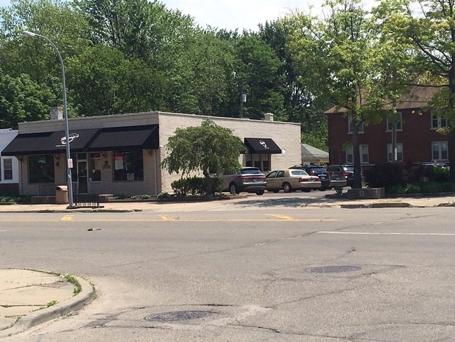
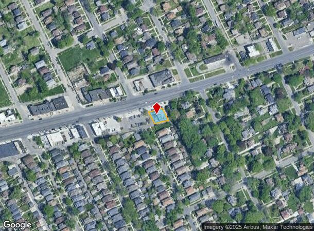
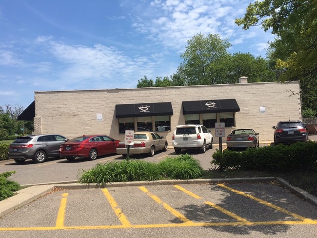
Property Record
15506 Mack Ave, Grosse Pointe Park, MI 48230
NEARBY LISTINGS FOR SALE OR LEASE
Property Detail
15506 Mack Ave
Detroit-Warren-Dearborn, MI
Somerset Road
39-007-02-0002-001
PKY2A 3A 4A SLY 72 FT OF LOT 2 3 AND 4 SOMERSET ROAD SUB PC 126,127 L37 P55 WCR
Restaurantbuilding
Wayne
X
Michigan
26163C0140F
2-3
2025
0.13 AC
2025
The Pointes/Harper Woods
550200
Detroit
2,996 SF
DEMOGRAPHICS near 15506 Mack Ave
1 mile
3 mile
5 mile
2024 Total Population
17,885
110,570
232,243
2029 Population
17,647
110,251
232,033
Pop Growth 2024-2029
(1.33%)
(0.29%)
(0.09%)
Average Age
38
39
39
2024 Total Households
6,903
42,056
90,769
HH Growth 2024-2029
(1.35%)
(0.34%)
(0.20%)
Median Household Inc
$63,698
$46,438
$46,888
Avg Household Size
2.50
2.50
2.50
2024 Avg HH Vehicles
2.00
1.00
1.00
Median Home Value
$229,040
$153,839
$130,387
Median Year Built
1946
1948
1950
Nearby Places
Map Layers
Map Styles
 Street
 Aerial
Transit
 Traffic
 Biking
Places
Listings with unknown addresses are not visible on the map
- Restaurants
- Banks
- Shops
- Fitness
- Groceries
PUBLIC TRANSPORTATION
COMMUTER RAIL
Drive
Walk
Distance
16 min
8.1 mi
AIRPORT
Windsor International
Drive
Walk
Distance
Windsor International
42 min
16.5 mi
Detroit Metro Wayne County
Drive
Walk
Distance
Detroit Metro Wayne County
45 min
29.1 mi
Freight Ports
Drive
Walk
Distance
91 min
69.8 mi
SALE & LEASE HISTORY
LISTING DATE
SALE/LEASE

Jun 06, 2017
For Sale
Apr 26, 2018
For Sale
Nearby Properties
Address
Land Use
TOTAL SIZE
Lot Size
Zoning
Address
Land Use
TOTAL SIZE
Lot Size
Zoning
2,958,207 SF
277.38 AC
M4
Address
Land Use
TOTAL SIZE
Lot Size
Zoning
2,005,073 SF
108.66 AC
M4
Address
Land Use
TOTAL SIZE
Lot Size
Zoning
929,400 SF
52.48 AC
M4
Address
Land Use
TOTAL SIZE
Lot Size
Zoning
482,649 SF
M4
Address
Land Use
TOTAL SIZE
Lot Size
Zoning
575,081 SF
8.53 AC
R6
Address
Land Use
TOTAL SIZE
Lot Size
Zoning
298,117 SF
15.97 AC
PD
Address
Land Use
TOTAL SIZE
Lot Size
Zoning
101,733 SF
1.10 AC
C-2
Address
Land Use
TOTAL SIZE
Lot Size
Zoning
49,437 SF
0.47 AC
Address
Land Use
TOTAL SIZE
Lot Size
Zoning
57.16 AC
M4
Address
Land Use
TOTAL SIZE
Lot Size
Zoning
93,296 SF
1.05 AC
C-2
Address
Land Use
TOTAL SIZE
Lot Size
Zoning
62,195 SF
1.50 AC
Address
Land Use
TOTAL SIZE
Lot Size
Zoning
17,558 SF
3.15 AC
Address
Land Use
TOTAL SIZE
Lot Size
Zoning
41,000 SF
C-1
Address
Land Use
TOTAL SIZE
Lot Size
Zoning
12,676 SF
1.93 AC
Address
Land Use
TOTAL SIZE
Lot Size
Zoning
89,897 SF
2.23 AC
Address
Land Use
TOTAL SIZE
Lot Size
Zoning
20,223 SF
2.87 AC
Address
Land Use
TOTAL SIZE
Lot Size
Zoning
129,260 SF
3 AC
B4
Address
Land Use
TOTAL SIZE
Lot Size
Zoning
72,940 SF
83.37 AC
M4
Address
Land Use
TOTAL SIZE
Lot Size
Zoning
7,787 SF
1.12 AC
Address
Land Use
TOTAL SIZE
Lot Size
Zoning
9,683 SF
1.91 AC
Address
Land Use
TOTAL SIZE
Lot Size
Zoning
93,850 SF
6.56 AC
Address
Land Use
TOTAL SIZE
Lot Size
Zoning
12,800 SF
1.46 AC
Address
Land Use
TOTAL SIZE
Lot Size
Zoning
88,695 SF
6.53 AC
PD
Address
Land Use
TOTAL SIZE
Lot Size
Zoning
115,839 SF
8.54 AC
M4
Address
Land Use
TOTAL SIZE
Lot Size
Zoning
7,830 SF
2.06 AC
Address
Land Use
TOTAL SIZE
Lot Size
Zoning
13,006 SF
3.46 AC
Address
Land Use
TOTAL SIZE
Lot Size
Zoning
28,055 SF
0.44 AC
Address
Land Use
TOTAL SIZE
Lot Size
Zoning
10,350 SF
0.57 AC
Address
Land Use
TOTAL SIZE
Lot Size
Zoning
6,600 SF
2.07 AC
Address
Land Use
TOTAL SIZE
Lot Size
Zoning
42,113 SF
0.54 AC
The World's #1 Commercial Real Estate Marketplace
Connect with us
© 2026 CoStar Group
The information above has been obtained from sources believed reliable. While we do not doubt its accuracy we have not verified it and make no guarantee, warranty or representation about it. It is your responsibility to independently confirm its accuracy and completeness. Any projections, opinions, assumptions, or estimates used are for example only and do not represent the current or future performance of the property. The value of this transaction to you depends on tax and other factors which should be evaluated by your tax, financial, and legal advisors. You and your advisors should conduct a careful, independent investigation of the property to determine to your satisfaction the suitability of the property for your needs.