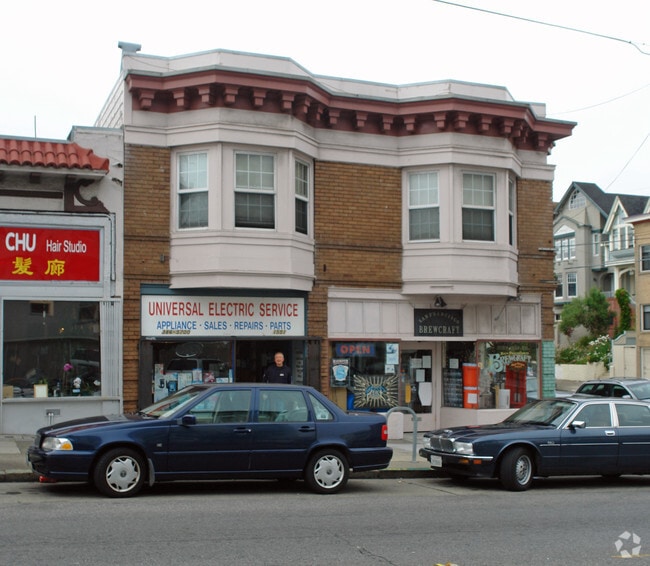
Property Record
300 17Th Ave, San Francisco, CA 94121
Current Lease Availabilities
General Retail LEASE
$31.06 - $34.38 SF/YR
850 - 1,152 SF
NEARBY LISTINGS FOR SALE OR LEASE
Property Detail
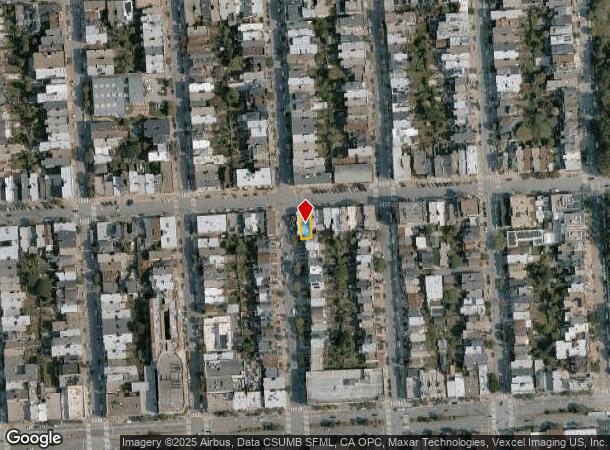
300 17Th Ave
San Francisco-Redwood City-South San Francisco, CA
San Francisco
1448-037
California
Retailwithmorethanonenonretailuse
37
2024
0.06 AC
2025
West of Van Ness
042602
San Francisco
4,674 SF
DEMOGRAPHICS near 300 17Th Ave
1 Mile
3 Mile
5 Mile
2024 Total Population
51,507
314,069
707,702
2029 Population
47,927
290,664
656,022
Pop Growth 2024-2029
(6.95%)
(7.45%)
(7.30%)
Average Age
43
43
43
2024 Total Households
21,655
139,538
313,169
HH Growth 2024-2029
(7.49%)
(7.92%)
(7.69%)
Median Household Inc
$131,085
$144,959
$130,306
Avg Household Size
2.30
2.20
2.10
2024 Avg HH Vehicles
1.00
1.00
1.00
Median Home Value
$1,122,980
$1,116,358
$1,107,123
Median Year Built
1947
1947
1948
Nearby Places
Map Layers
Map Styles
 Street
 Aerial
- Restaurants
- Banks
- Shops
- Fitness
- Groceries
PUBLIC TRANSPORTATION
COMMUTER RAIL
San Francisco 4th & King (Caltrain - Caltrain (Caltrain))
DRIVE
WALK
Distance
San Francisco 4th & King (Caltrain - Caltrain (Caltrain))
14 min
5.3 mi
DRIVE
WALK
Distance
14 min
5.4 mi
AIRPORT
San Francisco International
DRIVE
WALK
Distance
San Francisco International
30 min
16.1 mi
Metro Oakland International
DRIVE
WALK
Distance
Metro Oakland International
40 min
23.3 mi
Norman Y Mineta San Jose International
DRIVE
WALK
Distance
Norman Y Mineta San Jose International
66 min
49.0 mi
Freight Ports
Port of San Francisco
DRIVE
WALK
Distance
Port of San Francisco
12 min
5.1 mi
Nearby Properties
Address
Land Use
TOTAL SIZE
Lot Size
Zoning
Address
Land Use
TOTAL SIZE
Lot Size
Zoning
1,015,000 SF
2.43 AC
RC4
Address
Land Use
TOTAL SIZE
Lot Size
Zoning
718 SF
18.55 AC
RH2
Address
Land Use
TOTAL SIZE
Lot Size
Zoning
89,551 SF
0.73 AC
RC4
Address
Land Use
TOTAL SIZE
Lot Size
Zoning
409,895 SF
7.20 AC
RH3
Address
Land Use
TOTAL SIZE
Lot Size
Zoning
524,271 SF
1.06 AC
RC4
Address
Land Use
TOTAL SIZE
Lot Size
Zoning
2.40 AC
NC3
Address
Land Use
TOTAL SIZE
Lot Size
Zoning
250,843 SF
6.62 AC
NC3
Address
Land Use
TOTAL SIZE
Lot Size
Zoning
1.68 AC
RM2
Address
Land Use
TOTAL SIZE
Lot Size
Zoning
17.91 AC
RH-2
Address
Land Use
TOTAL SIZE
Lot Size
Zoning
420,000 SF
0.79 AC
NC-3
Address
Land Use
TOTAL SIZE
Lot Size
Zoning
1.14 AC
P
Address
Land Use
TOTAL SIZE
Lot Size
Zoning
4.41 AC
RH-3/RM-2
Address
Land Use
TOTAL SIZE
Lot Size
Zoning
905,491 SF
10.27 AC
RM1
Address
Land Use
TOTAL SIZE
Lot Size
Zoning
230,310 SF
0.65 AC
NC3
Address
Land Use
TOTAL SIZE
Lot Size
Zoning
140,380 SF
0.53 AC
NC3
Address
Land Use
TOTAL SIZE
Lot Size
Zoning
141,397 SF
0.88 AC
RM-4
Address
Land Use
TOTAL SIZE
Lot Size
Zoning
2.24 AC
RM3
Address
Land Use
TOTAL SIZE
Lot Size
Zoning
0.29 AC
RM4
Address
Land Use
TOTAL SIZE
Lot Size
Zoning
75,989 SF
0.72 AC
Address
Land Use
TOTAL SIZE
Lot Size
Zoning
116,000 SF
0.38 AC
RC4
Address
Land Use
TOTAL SIZE
Lot Size
Zoning
90,539 SF
2.28 AC
RH2
Address
Land Use
TOTAL SIZE
Lot Size
Zoning
95,303 SF
0.30 AC
RC4
Address
Land Use
TOTAL SIZE
Lot Size
Zoning
14,525 SF
0.46 AC
NC2
Address
Land Use
TOTAL SIZE
Lot Size
Zoning
107,588 SF
1.04 AC
RM1
Address
Land Use
TOTAL SIZE
Lot Size
Zoning
70,563 SF
0.42 AC
Address
Land Use
TOTAL SIZE
Lot Size
Zoning
88,402 SF
1.03 AC
RM1RM2
Address
Land Use
TOTAL SIZE
Lot Size
Zoning
165,485 SF
0.52 AC
RH2
Address
Land Use
TOTAL SIZE
Lot Size
Zoning
146,036 SF
0.49 AC
RH3
Address
Land Use
TOTAL SIZE
Lot Size
Zoning
127,189 SF
0.74 AC
RM2
Address
Land Use
TOTAL SIZE
Lot Size
Zoning
0.06 AC
UPMKT
The World's #1 Commercial Real Estate Marketplace
Connect with us
© 2025 CoStar Group
The information above has been obtained from sources believed reliable. While we do not doubt its accuracy we have not verified it and make no guarantee, warranty or representation about it. It is your responsibility to independently confirm its accuracy and completeness. Any projections, opinions, assumptions, or estimates used are for example only and do not represent the current or future performance of the property. The value of this transaction to you depends on tax and other factors which should be evaluated by your tax, financial, and legal advisors. You and your advisors should conduct a careful, independent investigation of the property to determine to your satisfaction the suitability of the property for your needs.