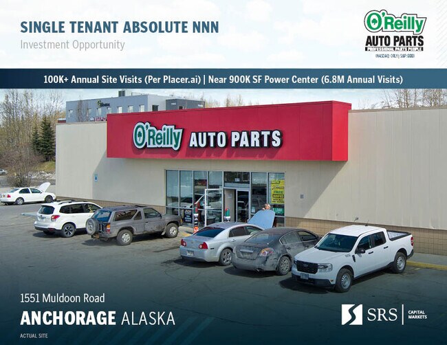
Property Record
1551 Muldoon Rd, Anchorage, AK 99504

NEARBY LISTINGS FOR SALE OR LEASE
Property Detail
1551 Muldoon Rd
Anchorage, AK
Abbas #1
00640344000
ABBAS #1 BLK 2 LT 1
Storebuilding
Anchorage
X
Alaska
0200050778D
1
2024
0.70 AC
2025
Outlying Anchorage
001731
Anchorage
7,000 SF
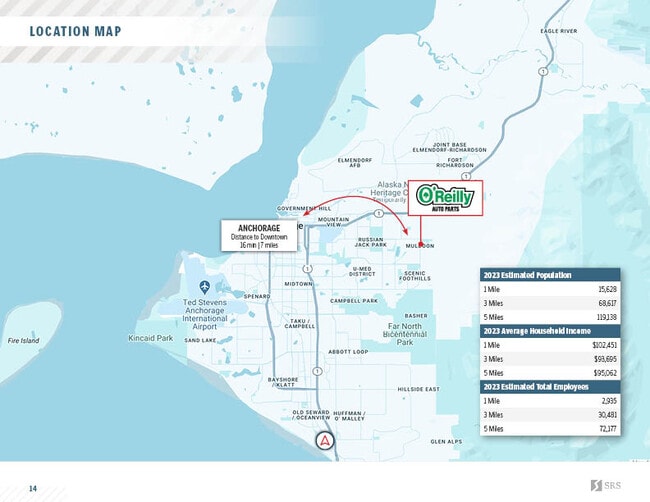
DEMOGRAPHICS near 1551 Muldoon Rd
1 Mile
3 Mile
5 Mile
2024 Total Population
15,442
73,663
121,832
2029 Population
15,280
73,094
120,603
Pop Growth 2024-2029
(1.05%)
(0.77%)
(1.01%)
Average Age
37
35
36
2024 Total Households
5,400
26,095
44,524
HH Growth 2024-2029
(1.06%)
(0.84%)
(1.07%)
Median Household Inc
$78,597
$71,807
$72,038
Avg Household Size
2.60
2.60
2.50
2024 Avg HH Vehicles
2.00
2.00
2.00
Median Home Value
$300,243
$271,637
$286,468
Median Year Built
1980
1980
1979
Nearby Places
Map Layers
Map Styles
 Street
 Aerial
- Restaurants
- Banks
- Shops
- Fitness
- Groceries
PUBLIC TRANSPORTATION
AIRPORT
Merrill Field
DRIVE
WALK
Distance
Merrill Field
11 min
4.4 mi
Ted Stevens Anchorage International
DRIVE
WALK
Distance
Ted Stevens Anchorage International
19 min
10.9 mi
Freight Ports
Port of Anchorage
DRIVE
WALK
Distance
Port of Anchorage
17 min
8.5 mi
SALE & LEASE HISTORY
LISTING DATE
SALE/LEASE

May 23, 2024
For Sale
Nearby Properties
Address
Land Use
TOTAL SIZE
Lot Size
Zoning
Address
Land Use
TOTAL SIZE
Lot Size
Zoning
380,635 SF
10.82 AC
B3
Address
Land Use
TOTAL SIZE
Lot Size
Zoning
160,830 SF
41.64 AC
PLI
Address
Land Use
TOTAL SIZE
Lot Size
Zoning
33,906 SF
40 AC
PLI
Address
Land Use
TOTAL SIZE
Lot Size
Zoning
179,543 SF
26.03 AC
PLI
Address
Land Use
TOTAL SIZE
Lot Size
Zoning
41,034 SF
6.28 AC
B3
Address
Land Use
TOTAL SIZE
Lot Size
Zoning
171,604 SF
30.51 AC
PLI
Address
Land Use
TOTAL SIZE
Lot Size
Zoning
104,412 SF
2.79 AC
B3SL
Address
Land Use
TOTAL SIZE
Lot Size
Zoning
294,060 SF
69.74 AC
PLI
Address
Land Use
TOTAL SIZE
Lot Size
Zoning
320,366 SF
36.42 AC
PLI
Address
Land Use
TOTAL SIZE
Lot Size
Zoning
24,120 SF
4.68 AC
B3
Address
Land Use
TOTAL SIZE
Lot Size
Zoning
173,845 SF
19.98 AC
R2A
Address
Land Use
TOTAL SIZE
Lot Size
Zoning
204,769 SF
13.08 AC
R4SL
Address
Land Use
TOTAL SIZE
Lot Size
Zoning
49,217 SF
4.76 AC
B3
Address
Land Use
TOTAL SIZE
Lot Size
Zoning
1,800 SF
26.71 AC
PLI
Address
Land Use
TOTAL SIZE
Lot Size
Zoning
8,189 SF
26.11 AC
R3
Address
Land Use
TOTAL SIZE
Lot Size
Zoning
43,325 SF
28.68 AC
PLI
Address
Land Use
TOTAL SIZE
Lot Size
Zoning
48.70 AC
PLI
Address
Land Use
TOTAL SIZE
Lot Size
Zoning
190,766 SF
16.45 AC
I1
Address
Land Use
TOTAL SIZE
Lot Size
Zoning
11,457 SF
2.81 AC
ROSL
Address
Land Use
TOTAL SIZE
Lot Size
Zoning
62,020 SF
12.42 AC
I1SL
Address
Land Use
TOTAL SIZE
Lot Size
Zoning
170,534 SF
11.13 AC
B3SL
Address
Land Use
TOTAL SIZE
Lot Size
Zoning
18,081 SF
149.52 AC
PLI
Address
Land Use
TOTAL SIZE
Lot Size
Zoning
183,438 SF
16.63 AC
B3SL
Address
Land Use
TOTAL SIZE
Lot Size
Zoning
35,192 SF
6.48 AC
ROSL
Address
Land Use
TOTAL SIZE
Lot Size
Zoning
19,000 SF
38.48 AC
PLI
Address
Land Use
TOTAL SIZE
Lot Size
Zoning
67,206 SF
3.69 AC
PLI
Address
Land Use
TOTAL SIZE
Lot Size
Zoning
37,360 SF
5.42 AC
PLI
Address
Land Use
TOTAL SIZE
Lot Size
Zoning
68,941 SF
10.64 AC
B3SL
Address
Land Use
TOTAL SIZE
Lot Size
Zoning
38,341 SF
3.19 AC
R3
Address
Land Use
TOTAL SIZE
Lot Size
Zoning
57,970 SF
4.28 AC
ROSL
The World's #1 Commercial Real Estate Marketplace
Connect with us
© 2026 CoStar Group
The information above has been obtained from sources believed reliable. While we do not doubt its accuracy we have not verified it and make no guarantee, warranty or representation about it. It is your responsibility to independently confirm its accuracy and completeness. Any projections, opinions, assumptions, or estimates used are for example only and do not represent the current or future performance of the property. The value of this transaction to you depends on tax and other factors which should be evaluated by your tax, financial, and legal advisors. You and your advisors should conduct a careful, independent investigation of the property to determine to your satisfaction the suitability of the property for your needs.