Property Record
1551 Palmetto Dr, Portage, MI 49002

NEARBY LISTINGS FOR SALE OR LEASE
-
-
View all Portage listings for sale on LoopNet.com
Property Detail
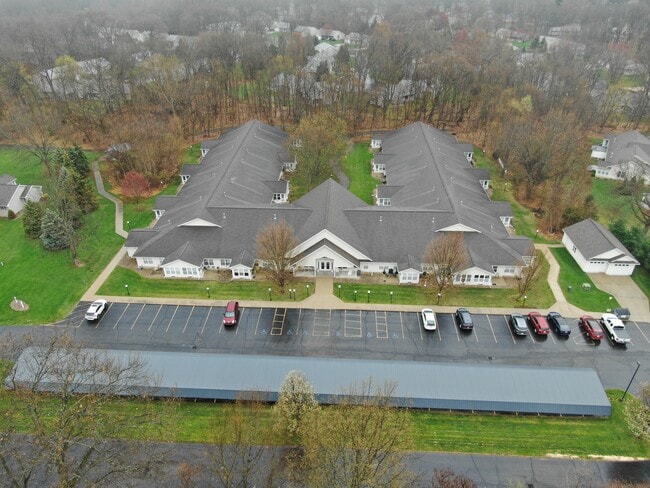
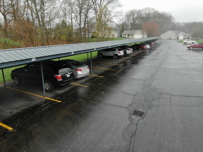
1551 Palmetto Dr
10-00027-195-I
Unit 35
Commercialnec
UNIT NO. 35 STERLING OAKS SOUTH CONDOMINUM
X
Kalamazoo
26077C0315E
Michigan
2025
5.46 AC
2025
Portage
002104
West Michigan
35,850 SF
Kalamazoo-Portage, MI
DEMOGRAPHICS near 1551 Palmetto Dr
1 Mile
3 Mile
5 Mile
2024 Total Population
4,764
22,579
60,353
2029 Population
4,742
22,542
60,134
Pop Growth 2024-2029
(0.46%)
(0.16%)
(0.36%)
Average Age
42
41
40
2024 Total Households
1,895
9,280
24,851
HH Growth 2024-2029
(0.47%)
(0.17%)
(0.40%)
Median Household Inc
$81,435
$74,150
$71,246
Avg Household Size
2.50
2.40
2.40
2024 Avg HH Vehicles
2.00
2.00
2.00
Median Home Value
$262,020
$230,972
$228,079
Median Year Built
1990
1976
1975
Nearby Places
Map Layers
Map Styles
 Street
 Aerial
- Restaurants
- Banks
- Shops
- Fitness
- Groceries
PUBLIC TRANSPORTATION
COMMUTER RAIL
Kalamazoo (Blue Water - Amtrak, Wolverine - Amtrak)
DRIVE
WALK
Distance
Kalamazoo (Blue Water - Amtrak, Wolverine - Amtrak)
21 min
9.6 mi
AIRPORT
Kalamazoo/Battle Creek International
DRIVE
WALK
Distance
Kalamazoo/Battle Creek International
18 min
7.0 mi
Freight Ports
Port of Toledo
DRIVE
WALK
Distance
Port of Toledo
182 min
148.6 mi
SALE & LEASE HISTORY
LISTING DATE
SALE/LEASE

May 02, 2022
For Sale
Nearby Properties
Address
Land Use
TOTAL SIZE
Lot Size
Zoning
Address
Land Use
TOTAL SIZE
Lot Size
Zoning
435.98 AC
I-2
Address
Land Use
TOTAL SIZE
Lot Size
Zoning
Address
Land Use
TOTAL SIZE
Lot Size
Zoning
691,902 SF
12.34 AC
Address
Land Use
TOTAL SIZE
Lot Size
Zoning
78.75 AC
I-2
Address
Land Use
TOTAL SIZE
Lot Size
Zoning
Address
Land Use
TOTAL SIZE
Lot Size
Zoning
Address
Land Use
TOTAL SIZE
Lot Size
Zoning
Address
Land Use
TOTAL SIZE
Lot Size
Zoning
19.39 AC
OTR
Address
Land Use
TOTAL SIZE
Lot Size
Zoning
18.57 AC
Address
Land Use
TOTAL SIZE
Lot Size
Zoning
16.58 AC
Address
Land Use
TOTAL SIZE
Lot Size
Zoning
28.49 AC
I-2
Address
Land Use
TOTAL SIZE
Lot Size
Zoning
151,395 SF
33.79 AC
CPD
Address
Land Use
TOTAL SIZE
Lot Size
Zoning
66.34 AC
B-3
Address
Land Use
TOTAL SIZE
Lot Size
Zoning
188,352 SF
67.55 AC
Address
Land Use
TOTAL SIZE
Lot Size
Zoning
20,760 SF
12.86 AC
RM-1
Address
Land Use
TOTAL SIZE
Lot Size
Zoning
9,246 SF
10.24 AC
RM-1
Address
Land Use
TOTAL SIZE
Lot Size
Zoning
168,173 SF
16.32 AC
I-2
Address
Land Use
TOTAL SIZE
Lot Size
Zoning
120,324 SF
10.67 AC
OS-1
Address
Land Use
TOTAL SIZE
Lot Size
Zoning
380,000 SF
40.75 AC
I-2
Address
Land Use
TOTAL SIZE
Lot Size
Zoning
135,548 SF
12.45 AC
CPD
Address
Land Use
TOTAL SIZE
Lot Size
Zoning
44,494 SF
I-2
Address
Land Use
TOTAL SIZE
Lot Size
Zoning
22,809 SF
6.80 AC
RM-1
Address
Land Use
TOTAL SIZE
Lot Size
Zoning
4.72 AC
OS-1
Address
Land Use
TOTAL SIZE
Lot Size
Zoning
45,000 SF
5.08 AC
B-3
Address
Land Use
TOTAL SIZE
Lot Size
Zoning
7.80 AC
B-3
Address
Land Use
TOTAL SIZE
Lot Size
Zoning
3.90 AC
OS-1
Address
Land Use
TOTAL SIZE
Lot Size
Zoning
13.63 AC
OS-1
Address
Land Use
TOTAL SIZE
Lot Size
Zoning
40,008 SF
12.01 AC
B-2
Address
Land Use
TOTAL SIZE
Lot Size
Zoning
1,500 SF
I-2
Address
Land Use
TOTAL SIZE
Lot Size
Zoning
5.70 AC
I-1
The World's #1 Commercial Real Estate Marketplace
Connect with us
© 2026 CoStar Group
The information above has been obtained from sources believed reliable. While we do not doubt its accuracy we have not verified it and make no guarantee, warranty or representation about it. It is your responsibility to independently confirm its accuracy and completeness. Any projections, opinions, assumptions, or estimates used are for example only and do not represent the current or future performance of the property. The value of this transaction to you depends on tax and other factors which should be evaluated by your tax, financial, and legal advisors. You and your advisors should conduct a careful, independent investigation of the property to determine to your satisfaction the suitability of the property for your needs.