Property Record
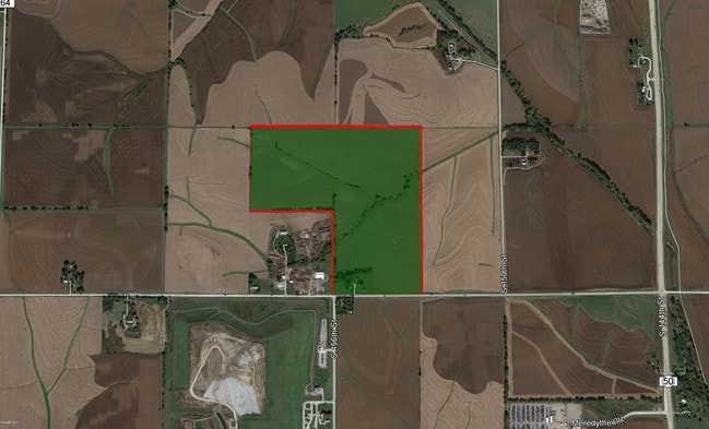
15510 Fairview Rd, Springfield, NE 68059


Property Detail
15510 Fairview Rd
010460276
NE1/4 SE1/4 10-13-11 (39.95 AC)
Commercialnec
SARPY
AG
Nebraska
B and X Area of moderate flood hazard, usually the area between the limits of the 100-year and 500-year floods.
39.96 AC
2024
Southwest Omaha
2025
Omaha/Council Bluffs
010701
Omaha, NE-IA
NEARBY LISTINGS FOR SALE OR LEASE
-
-
S 158th St. & Gold Coast Rd. - Lot 4, Steel Ridge South
Omaha, NE 68138
$6,450,000
19.60 AC Lots
Land
-
-
-
-
-
View all Springfield listings for sale on LoopNet.com
DEMOGRAPHICS near 15510 Fairview Rd
1 mile
3 mile
5 mile
2025 Total Population
19
4,158
35,699
2030 Population
20
4,520
39,005
Pop Growth 2025-2030
+ 5.26%
+ 8.71%
+ 9.26%
Average Age
38
40
37
2025 Total Households
6
1,526
12,518
HH Growth 2025-2030
+ 16.67%
+ 8.91%
+ 9.37%
Median Household Inc
$124,999
$115,322
$118,220
Avg Household Size
2.80
2.70
2.80
2025 Avg HH Vehicles
3.00
2.00
2.00
Median Home Value
$450,000
$415,890
$404,229
Median Year Built
1994
1997
2007
Nearby Places
Map Layers
Map Styles
 Street
 Aerial
Transit
 Traffic
 Biking
Places
Listings with unknown addresses are not visible on the map
- Restaurants
- Banks
- Shops
- Fitness
- Groceries
PUBLIC TRANSPORTATION
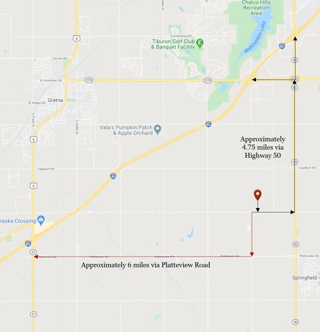
AIRPORT
Eppley Airfield
Drive
Walk
Distance
Eppley Airfield
35 min
23.9 mi
Freight Ports
Tulsa Port Of Catoosa
Drive
Walk
Distance
Tulsa Port Of Catoosa
466 min
418.7 mi
SALE & LEASE HISTORY
LISTING DATE
SALE/LEASE

Sep 28, 2018
For Sale
Sep 24, 2016
For Sale
Feb 27, 2017
For Sale
Apr 26, 2021
For Sale
Apr 17, 2017
For Sale
Nearby Properties
Address
Land Use
TOTAL SIZE
Lot Size
Zoning
Address
Land Use
TOTAL SIZE
Lot Size
Zoning
181,712 SF
131.75 AC
Address
Land Use
TOTAL SIZE
Lot Size
Zoning
1,831 SF
173.14 AC
Address
Land Use
TOTAL SIZE
Lot Size
Zoning
2,400 SF
21.27 AC
Address
Land Use
TOTAL SIZE
Lot Size
Zoning
51.65 AC
Address
Land Use
TOTAL SIZE
Lot Size
Zoning
48.50 AC
Address
Land Use
TOTAL SIZE
Lot Size
Zoning
9,600 SF
2.07 AC
IL
Address
Land Use
TOTAL SIZE
Lot Size
Zoning
334,533 SF
23.32 AC
Address
Land Use
TOTAL SIZE
Lot Size
Zoning
17.40 AC
Address
Land Use
TOTAL SIZE
Lot Size
Zoning
24,294 SF
25.79 AC
Address
Land Use
TOTAL SIZE
Lot Size
Zoning
183,184 SF
20.66 AC
Address
Land Use
TOTAL SIZE
Lot Size
Zoning
27,027 SF
11.15 AC
Address
Land Use
TOTAL SIZE
Lot Size
Zoning
16.57 AC
Address
Land Use
TOTAL SIZE
Lot Size
Zoning
250,999 SF
17.10 AC
Address
Land Use
TOTAL SIZE
Lot Size
Zoning
250,999 SF
15.44 AC
Address
Land Use
TOTAL SIZE
Lot Size
Zoning
Address
Land Use
TOTAL SIZE
Lot Size
Zoning
17.75 AC
Address
Land Use
TOTAL SIZE
Lot Size
Zoning
184,800 SF
8.85 AC
Address
Land Use
TOTAL SIZE
Lot Size
Zoning
184,800 SF
9.41 AC
Address
Land Use
TOTAL SIZE
Lot Size
Zoning
9.76 AC
Address
Land Use
TOTAL SIZE
Lot Size
Zoning
2,125 SF
142.25 AC
Address
Land Use
TOTAL SIZE
Lot Size
Zoning
16.25 AC
Address
Land Use
TOTAL SIZE
Lot Size
Zoning
155,635 SF
22.14 AC
BG
Address
Land Use
TOTAL SIZE
Lot Size
Zoning
11.43 AC
Address
Land Use
TOTAL SIZE
Lot Size
Zoning
10.06 AC
Address
Land Use
TOTAL SIZE
Lot Size
Zoning
14,432 SF
13 AC
Address
Land Use
TOTAL SIZE
Lot Size
Zoning
17,076 SF
13 AC
Address
Land Use
TOTAL SIZE
Lot Size
Zoning
35,107 SF
13.15 AC
Address
Land Use
TOTAL SIZE
Lot Size
Zoning
160.34 AC
AG
Address
Land Use
TOTAL SIZE
Lot Size
Zoning
103,716 SF
5.62 AC
IL
Address
Land Use
TOTAL SIZE
Lot Size
Zoning
11.40 AC
The World's #1 Commercial Real Estate Marketplace
Connect with us
© 2026 CoStar Group
The information above has been obtained from sources believed reliable. While we do not doubt its accuracy we have not verified it and make no guarantee, warranty or representation about it. It is your responsibility to independently confirm its accuracy and completeness. Any projections, opinions, assumptions, or estimates used are for example only and do not represent the current or future performance of the property. The value of this transaction to you depends on tax and other factors which should be evaluated by your tax, financial, and legal advisors. You and your advisors should conduct a careful, independent investigation of the property to determine to your satisfaction the suitability of the property for your needs.