Property Record
15511 W 8 Mile Rd, Detroit, MI 48235


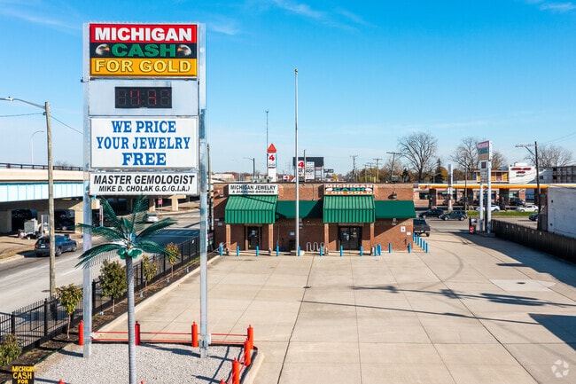
This Property Is For Sale
NEARBY LISTINGS FOR SALE OR LEASE
Property Detail
15511 W 8 Mile Rd
Detroit-Warren-Dearborn, MI
Maloney Park
22-01873-749
S EIGHT MILE W LOTS 10 THRU 21 E 10 FT 22 MALONEY PARK SUB L60 P2 PLATS, W C R 22/610 250 X 100 SPLIT/COMBINED ON 05/17/2017 FROM 22018737-44, 22018745-9;
Storebuilding
Wayne
X
Michigan
26163C0100E
10-21
2025
0.57 AC
2025
Detroit W of Woodward
539200
Detroit
3,720 SF
DEMOGRAPHICS near 15511 W 8 Mile Rd
1 Mile
3 Mile
5 Mile
2024 Total Population
16,014
154,033
374,113
2029 Population
15,779
150,747
368,773
Pop Growth 2024-2029
(1.47%)
(2.13%)
(1.43%)
Average Age
41
40
40
2024 Total Households
6,467
62,139
157,240
HH Growth 2024-2029
(1.48%)
(2.15%)
(1.40%)
Median Household Inc
$39,748
$48,510
$52,977
Avg Household Size
2.40
2.40
2.30
2024 Avg HH Vehicles
1.00
1.00
1.00
Median Home Value
$94,371
$124,268
$157,085
Median Year Built
1955
1954
1952
Nearby Places
Map Layers
Map Styles
 Street
 Aerial
- Restaurants
- Banks
- Shops
- Fitness
- Groceries
PUBLIC TRANSPORTATION
COMMUTER RAIL
Royal Oak Amtrak (Wolverine - Amtrak)
DRIVE
WALK
Distance
Royal Oak Amtrak (Wolverine - Amtrak)
12 min
6.2 mi
Troy Amtrak Station (Wolverine - Amtrak)
DRIVE
WALK
Distance
Troy Amtrak Station (Wolverine - Amtrak)
17 min
8.3 mi
AIRPORT
Windsor International
DRIVE
WALK
Distance
Windsor International
40 min
21.8 mi
Detroit Metro Wayne County
DRIVE
WALK
Distance
Detroit Metro Wayne County
37 min
24.1 mi
Freight Ports
Port of Toledo
DRIVE
WALK
Distance
Port of Toledo
86 min
66.2 mi
Nearby Properties
Address
Land Use
TOTAL SIZE
Lot Size
Zoning
Address
Land Use
TOTAL SIZE
Lot Size
Zoning
925,367 SF
12.82 AC
R6
Address
Land Use
TOTAL SIZE
Lot Size
Zoning
187,801 SF
5.49 AC
RM-2
Address
Land Use
TOTAL SIZE
Lot Size
Zoning
120,093 SF
38.18 AC
TV-R
Address
Land Use
TOTAL SIZE
Lot Size
Zoning
300,830 SF
54 AC
LI
Address
Land Use
TOTAL SIZE
Lot Size
Zoning
97.05 AC
RS
Address
Land Use
TOTAL SIZE
Lot Size
Zoning
339,780 SF
22.29 AC
RM-1
Address
Land Use
TOTAL SIZE
Lot Size
Zoning
133,544 SF
19.65 AC
ERO
Address
Land Use
TOTAL SIZE
Lot Size
Zoning
417,880 SF
6.76 AC
RM-2
Address
Land Use
TOTAL SIZE
Lot Size
Zoning
273,000 SF
17.31 AC
LI
Address
Land Use
TOTAL SIZE
Lot Size
Zoning
290,448 SF
9.01 AC
O
Address
Land Use
TOTAL SIZE
Lot Size
Zoning
200 SF
12.69 AC
RM
Address
Land Use
TOTAL SIZE
Lot Size
Zoning
11.11 AC
RS
Address
Land Use
TOTAL SIZE
Lot Size
Zoning
10.32 AC
LI
Address
Land Use
TOTAL SIZE
Lot Size
Zoning
216 SF
13.14 AC
RM
Address
Land Use
TOTAL SIZE
Lot Size
Zoning
143,700 SF
3.27 AC
PD
Address
Land Use
TOTAL SIZE
Lot Size
Zoning
163,661 SF
8.92 AC
PD
Address
Land Use
TOTAL SIZE
Lot Size
Zoning
290,448 SF
8.92 AC
O
Address
Land Use
TOTAL SIZE
Lot Size
Zoning
230,048 SF
11.06 AC
RC
Address
Land Use
TOTAL SIZE
Lot Size
Zoning
176 SF
9.85 AC
RM
Address
Land Use
TOTAL SIZE
Lot Size
Zoning
240,520 SF
8.14 AC
B-3
Address
Land Use
TOTAL SIZE
Lot Size
Zoning
165,829 SF
5.56 AC
R5
Address
Land Use
TOTAL SIZE
Lot Size
Zoning
Address
Land Use
TOTAL SIZE
Lot Size
Zoning
93,329 SF
2.07 AC
ERO
Address
Land Use
TOTAL SIZE
Lot Size
Zoning
66,032 SF
3.61 AC
R-1
Address
Land Use
TOTAL SIZE
Lot Size
Zoning
180 SF
5.09 AC
RMU
Address
Land Use
TOTAL SIZE
Lot Size
Zoning
14.10 AC
RS
Address
Land Use
TOTAL SIZE
Lot Size
Zoning
4,060 SF
18.42 AC
RM
Address
Land Use
TOTAL SIZE
Lot Size
Zoning
54,672 SF
1.37 AC
R6
Address
Land Use
TOTAL SIZE
Lot Size
Zoning
51,246 SF
7.13 AC
ERO
Address
Land Use
TOTAL SIZE
Lot Size
Zoning
116,790 SF
5.86 AC
R4
The World's #1 Commercial Real Estate Marketplace
Connect with us
© 2026 CoStar Group
The information above has been obtained from sources believed reliable. While we do not doubt its accuracy we have not verified it and make no guarantee, warranty or representation about it. It is your responsibility to independently confirm its accuracy and completeness. Any projections, opinions, assumptions, or estimates used are for example only and do not represent the current or future performance of the property. The value of this transaction to you depends on tax and other factors which should be evaluated by your tax, financial, and legal advisors. You and your advisors should conduct a careful, independent investigation of the property to determine to your satisfaction the suitability of the property for your needs.