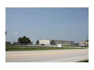
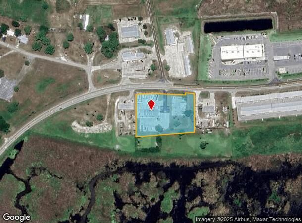
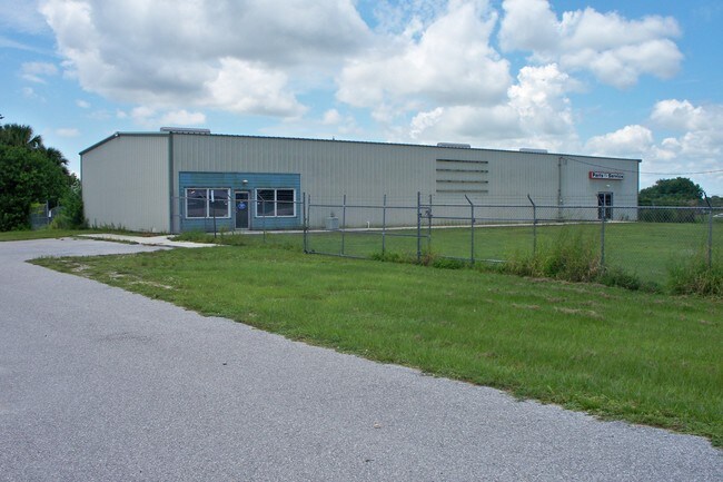
Property Record
1552 Highway 78 W, Okeechobee, FL 34974
NEARBY LISTINGS FOR SALE OR LEASE
Property Detail
1552 Highway 78 W
R1-04-38-35-0A00-00026-B000
The Meander Corner On The West Line
Storemultistory
A PARCEL OF LAND LYING IN SECTION 4, TOWNSHIP 38 SOUTH, RANGE 35 EAST, OKEECHOBEE COUNTY, FLORIDA. BEING MORE PARTICULARLY DESCRIBED AS FOLLOWS: BEGINNING AT THE MEANDER CORNER ON THE WEST LINE OF SAID SECTION 4 AND THE 17 CONTOUR LINE OF LAKE OKEECH
AE
Okeechobee
12043C0100D
Florida
2025
2.76 AC
2025
Florida Central South Area
910500
Other Market Areas
6,924 SF
Okeechobee, FL
DEMOGRAPHICS near 1552 Highway 78 W
1 Mile
3 Mile
5 Mile
2024 Total Population
426
7,845
22,047
2029 Population
466
8,425
23,495
Pop Growth 2024-2029
+ 9.39%
+ 7.39%
+ 6.57%
Average Age
64
48
44
2024 Total Households
235
3,561
9,085
HH Growth 2024-2029
+ 9.36%
+ 7.67%
+ 6.80%
Median Household Inc
$55,000
$51,250
$42,525
Avg Household Size
1.80
2.20
2.40
2024 Avg HH Vehicles
2.00
2.00
2.00
Median Home Value
$131,609
$142,638
$133,236
Median Year Built
1993
1988
1985
Nearby Places
Map Layers
Map Styles
 Street
 Aerial
- Restaurants
- Banks
- Shops
- Fitness
- Groceries
PUBLIC TRANSPORTATION
COMMUTER RAIL
Okeechobee Amtrak (Silver Star - Amtrak)
DRIVE
WALK
Distance
Okeechobee Amtrak (Silver Star - Amtrak)
9 min
4.8 mi
Freight Ports
Port of Palm Beach
DRIVE
WALK
Distance
Port of Palm Beach
87 min
60.1 mi
SALE & LEASE HISTORY
LISTING DATE
SALE/LEASE

Sep 23, 2016
For Sale
Feb 22, 2017
For Sale
Nearby Properties
Address
Land Use
TOTAL SIZE
Lot Size
Zoning
Address
Land Use
TOTAL SIZE
Lot Size
Zoning
46,720 SF
108.57 AC
Address
Land Use
TOTAL SIZE
Lot Size
Zoning
194,141 SF
30.69 AC
Address
Land Use
TOTAL SIZE
Lot Size
Zoning
166,487 SF
40 AC
Address
Land Use
TOTAL SIZE
Lot Size
Zoning
122,024 SF
14.12 AC
Address
Land Use
TOTAL SIZE
Lot Size
Zoning
133,382 SF
1.52 AC
Address
Land Use
TOTAL SIZE
Lot Size
Zoning
90,801 SF
15.10 AC
Address
Land Use
TOTAL SIZE
Lot Size
Zoning
99,186 SF
7.05 AC
Address
Land Use
TOTAL SIZE
Lot Size
Zoning
121,250 SF
10.31 AC
Address
Land Use
TOTAL SIZE
Lot Size
Zoning
2,887 SF
11.76 AC
Address
Land Use
TOTAL SIZE
Lot Size
Zoning
42,074 SF
34.62 AC
Address
Land Use
TOTAL SIZE
Lot Size
Zoning
76,008 SF
8.55 AC
Address
Land Use
TOTAL SIZE
Lot Size
Zoning
31,388 SF
11.32 AC
Address
Land Use
TOTAL SIZE
Lot Size
Zoning
62,297 SF
11.48 AC
Address
Land Use
TOTAL SIZE
Lot Size
Zoning
36,381 SF
2.48 AC
Address
Land Use
TOTAL SIZE
Lot Size
Zoning
3,176 SF
38.74 AC
Address
Land Use
TOTAL SIZE
Lot Size
Zoning
51,475 SF
8.66 AC
Address
Land Use
TOTAL SIZE
Lot Size
Zoning
45,770 SF
7.70 AC
Address
Land Use
TOTAL SIZE
Lot Size
Zoning
54,287 SF
2.67 AC
Address
Land Use
TOTAL SIZE
Lot Size
Zoning
42,323 SF
6.84 AC
Address
Land Use
TOTAL SIZE
Lot Size
Zoning
448.30 AC
Address
Land Use
TOTAL SIZE
Lot Size
Zoning
6,814 SF
2.55 AC
Address
Land Use
TOTAL SIZE
Lot Size
Zoning
160 SF
10.85 AC
Address
Land Use
TOTAL SIZE
Lot Size
Zoning
2,778 SF
5.30 AC
Address
Land Use
TOTAL SIZE
Lot Size
Zoning
46,339 SF
4.15 AC
Address
Land Use
TOTAL SIZE
Lot Size
Zoning
10,500 SF
1.02 AC
Address
Land Use
TOTAL SIZE
Lot Size
Zoning
3,216 SF
7.05 AC
Address
Land Use
TOTAL SIZE
Lot Size
Zoning
59,316 SF
13.47 AC
Address
Land Use
TOTAL SIZE
Lot Size
Zoning
21,891 SF
7.09 AC
Address
Land Use
TOTAL SIZE
Lot Size
Zoning
8,194 SF
2.58 AC
Address
Land Use
TOTAL SIZE
Lot Size
Zoning
1.20 AC
The World's #1 Commercial Real Estate Marketplace
Connect with us
© 2025 CoStar Group
The information above has been obtained from sources believed reliable. While we do not doubt its accuracy we have not verified it and make no guarantee, warranty or representation about it. It is your responsibility to independently confirm its accuracy and completeness. Any projections, opinions, assumptions, or estimates used are for example only and do not represent the current or future performance of the property. The value of this transaction to you depends on tax and other factors which should be evaluated by your tax, financial, and legal advisors. You and your advisors should conduct a careful, independent investigation of the property to determine to your satisfaction the suitability of the property for your needs.