Property Record
1553 N Dixie Hwy, Monroe, MI 48162
NEARBY LISTINGS FOR SALE OR LEASE
Property Detail
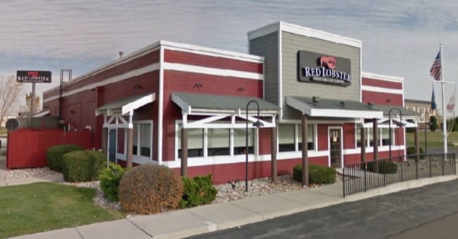
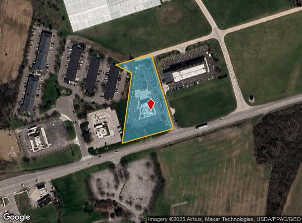
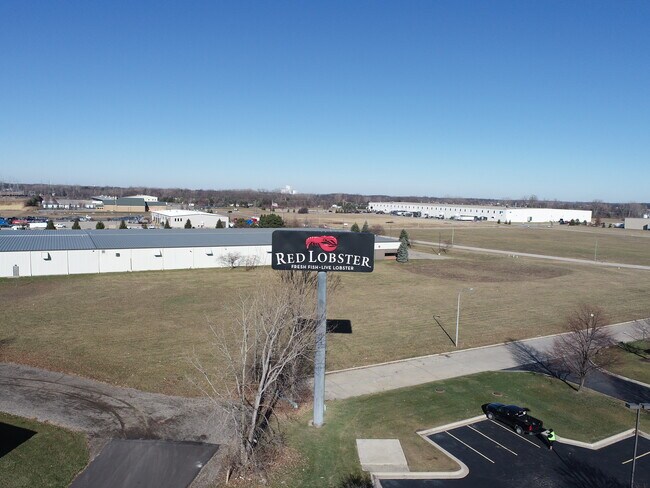
1553 N Dixie Hwy
Monroe, MI
Frenchtown Park I
07-807-001-00
SEC 34 T6S R9E FRENCHTOWN PARK PLAT 1 2.178 AMOL (SURVEY) LOT 1 DESC AS COM AT SW COR SD LOT 1 FOR POB, TH N 73 DEG 07'52"E
Restaurantbuilding
Monroe
X
Michigan
26115C0261F
1
2025
2.18 AC
2025
Monroe County
831700
Detroit
5,069 SF
DEMOGRAPHICS near 1553 N Dixie Hwy
1 Mile
3 Mile
5 Mile
2024 Total Population
1,131
26,329
51,800
2029 Population
1,143
26,747
52,661
Pop Growth 2024-2029
+ 1.06%
+ 1.59%
+ 1.66%
Average Age
41
41
41
2024 Total Households
447
10,683
21,231
HH Growth 2024-2029
+ 1.12%
+ 1.50%
+ 1.58%
Median Household Inc
$69,852
$60,660
$60,170
Avg Household Size
2.50
2.30
2.30
2024 Avg HH Vehicles
2.00
2.00
2.00
Median Home Value
$157,468
$151,880
$162,014
Median Year Built
1967
1957
1967
Nearby Places
Map Layers
Map Styles
 Street
 Aerial
- Restaurants
- Banks
- Shops
- Fitness
- Groceries
PUBLIC TRANSPORTATION
AIRPORT
Detroit Metro Wayne County
DRIVE
WALK
Distance
Detroit Metro Wayne County
34 min
24.1 mi
Eugene F Kranz Toledo Express
DRIVE
WALK
Distance
Eugene F Kranz Toledo Express
60 min
41.5 mi
Windsor International
DRIVE
WALK
Distance
Windsor International
62 min
44.3 mi
SALE & LEASE HISTORY
LISTING DATE
SALE/LEASE

Feb 13, 2019
For Sale
Dec 14, 2022
For Sale
Nearby Properties
Address
Land Use
TOTAL SIZE
Lot Size
Zoning
Address
Land Use
TOTAL SIZE
Lot Size
Zoning
5,088 SF
123.61 AC
R-1A
Address
Land Use
TOTAL SIZE
Lot Size
Zoning
48,845 SF
163.20 AC
R-1A
Address
Land Use
TOTAL SIZE
Lot Size
Zoning
200,000 SF
94.63 AC
CO
Address
Land Use
TOTAL SIZE
Lot Size
Zoning
409,765 SF
41.46 AC
Address
Land Use
TOTAL SIZE
Lot Size
Zoning
95.60 AC
Address
Land Use
TOTAL SIZE
Lot Size
Zoning
Address
Land Use
TOTAL SIZE
Lot Size
Zoning
195,744 SF
32.62 AC
C-2-COMMER
Address
Land Use
TOTAL SIZE
Lot Size
Zoning
Address
Land Use
TOTAL SIZE
Lot Size
Zoning
315,000 SF
24.47 AC
Address
Land Use
TOTAL SIZE
Lot Size
Zoning
3.97 AC
Address
Land Use
TOTAL SIZE
Lot Size
Zoning
108,575 SF
38.21 AC
R-1A
Address
Land Use
TOTAL SIZE
Lot Size
Zoning
507.34 AC
R-1A
Address
Land Use
TOTAL SIZE
Lot Size
Zoning
134,464 SF
34.35 AC
Address
Land Use
TOTAL SIZE
Lot Size
Zoning
69,590 SF
11.55 AC
C-2-COMMER
Address
Land Use
TOTAL SIZE
Lot Size
Zoning
291,322 SF
55.05 AC
Address
Land Use
TOTAL SIZE
Lot Size
Zoning
PS PUBLIC
Address
Land Use
TOTAL SIZE
Lot Size
Zoning
148,343 SF
15.15 AC
Address
Land Use
TOTAL SIZE
Lot Size
Zoning
Address
Land Use
TOTAL SIZE
Lot Size
Zoning
189,314 SF
28.56 AC
Address
Land Use
TOTAL SIZE
Lot Size
Zoning
94,324 SF
10.11 AC
Address
Land Use
TOTAL SIZE
Lot Size
Zoning
62,459 SF
2.59 AC
Address
Land Use
TOTAL SIZE
Lot Size
Zoning
290,248 SF
52.03 AC
Address
Land Use
TOTAL SIZE
Lot Size
Zoning
142,400 SF
15.20 AC
Address
Land Use
TOTAL SIZE
Lot Size
Zoning
43,127 SF
8.10 AC
Address
Land Use
TOTAL SIZE
Lot Size
Zoning
412,877 SF
22.35 AC
R-1A
Address
Land Use
TOTAL SIZE
Lot Size
Zoning
220,500 SF
31.81 AC
Address
Land Use
TOTAL SIZE
Lot Size
Zoning
200,700 SF
9.95 AC
R-1A
Address
Land Use
TOTAL SIZE
Lot Size
Zoning
31.45 AC
Address
Land Use
TOTAL SIZE
Lot Size
Zoning
75,437 SF
8.74 AC
R-1A
Address
Land Use
TOTAL SIZE
Lot Size
Zoning
The World's #1 Commercial Real Estate Marketplace
Connect with us
© 2026 CoStar Group
The information above has been obtained from sources believed reliable. While we do not doubt its accuracy we have not verified it and make no guarantee, warranty or representation about it. It is your responsibility to independently confirm its accuracy and completeness. Any projections, opinions, assumptions, or estimates used are for example only and do not represent the current or future performance of the property. The value of this transaction to you depends on tax and other factors which should be evaluated by your tax, financial, and legal advisors. You and your advisors should conduct a careful, independent investigation of the property to determine to your satisfaction the suitability of the property for your needs.