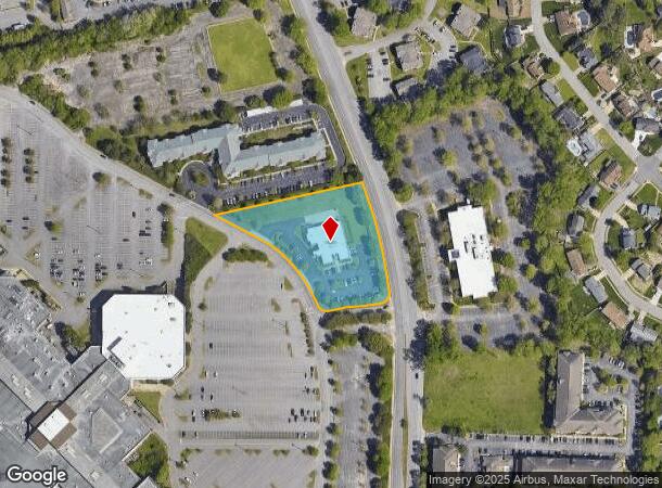
Property Record
1554 River Birch Run N, Chesapeake, VA 23320

NEARBY LISTINGS FOR SALE OR LEASE
Property Detail
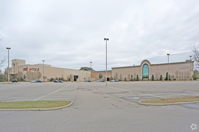
1554 River Birch Run N
0280000000630
Battlefield Volvo Grnbr Pkwy Corridor
Hospitalpublic
PAR E4 RESUB PLT PAR E2 & B1 GREENBRIER ZN 5 2.302
X
Chesapeake
5100340026D
Virginia
2021
2.30 AC
2025
Greenbrier
020813
Hampton Roads
9,782 SF
Virginia Beach-Norfolk-Newport News, VA-NC
DEMOGRAPHICS near 1554 River Birch Run N
1 Mile
3 Mile
5 Mile
2024 Total Population
8,710
102,148
214,785
2029 Population
8,970
104,001
217,183
Pop Growth 2024-2029
+ 2.99%
+ 1.81%
+ 1.12%
Average Age
38
39
39
2024 Total Households
4,097
40,645
82,657
HH Growth 2024-2029
+ 3.10%
+ 1.91%
+ 1.15%
Median Household Inc
$75,823
$76,253
$76,778
Avg Household Size
2.10
2.40
2.50
2024 Avg HH Vehicles
2.00
2.00
2.00
Median Home Value
$239,967
$263,838
$277,797
Median Year Built
1987
1985
1983
Nearby Places
Map Layers
Map Styles
 Street
 Aerial
- Restaurants
- Banks
- Shops
- Fitness
- Groceries
PUBLIC TRANSPORTATION
COMMUTER RAIL
DRIVE
WALK
Distance
16 min
7.9 mi
AIRPORT
Norfolk International
DRIVE
WALK
Distance
Norfolk International
20 min
11.5 mi
Newport News/Williamsburg International
DRIVE
WALK
Distance
Newport News/Williamsburg International
55 min
37.0 mi
Nearby Properties
Address
Land Use
TOTAL SIZE
Lot Size
Zoning
Address
Land Use
TOTAL SIZE
Lot Size
Zoning
470,098 SF
14.10 AC
O-I: OFFIC
Address
Land Use
TOTAL SIZE
Lot Size
Zoning
405,992 SF
40.22 AC
PUD: PLANN
Address
Land Use
TOTAL SIZE
Lot Size
Zoning
439,870 SF
24.90 AC
PUD: PLANN
Address
Land Use
TOTAL SIZE
Lot Size
Zoning
743,121 SF
57.42 AC
RMF1: MULT
Address
Land Use
TOTAL SIZE
Lot Size
Zoning
358,908 SF
22.21 AC
MULTI: MUL
Address
Land Use
TOTAL SIZE
Lot Size
Zoning
1 SF
20.80 AC
A18
Address
Land Use
TOTAL SIZE
Lot Size
Zoning
17.04 AC
A24
Address
Land Use
TOTAL SIZE
Lot Size
Zoning
209,403 SF
2.81 AC
PUD: PLANN
Address
Land Use
TOTAL SIZE
Lot Size
Zoning
95,354 SF
39.53 AC
B2: GENERA
Address
Land Use
TOTAL SIZE
Lot Size
Zoning
264,213 SF
17.59 AC
PUD: PLANN
Address
Land Use
TOTAL SIZE
Lot Size
Zoning
10.36 AC
A24
Address
Land Use
TOTAL SIZE
Lot Size
Zoning
145,522 SF
15.51 AC
PUD: PLANN
Address
Land Use
TOTAL SIZE
Lot Size
Zoning
71,711 SF
11.65 AC
B4
Address
Land Use
TOTAL SIZE
Lot Size
Zoning
3 SF
19.50 AC
A12
Address
Land Use
TOTAL SIZE
Lot Size
Zoning
168,391 SF
28.39 AC
B2: GENERA
Address
Land Use
TOTAL SIZE
Lot Size
Zoning
218,812 SF
45.15 AC
PUD: PLANN
Address
Land Use
TOTAL SIZE
Lot Size
Zoning
32,163 SF
17.59 AC
MULTI: MUL
Address
Land Use
TOTAL SIZE
Lot Size
Zoning
26.63 AC
Address
Land Use
TOTAL SIZE
Lot Size
Zoning
270,962 SF
6.17 AC
MXD-U: MIX
Address
Land Use
TOTAL SIZE
Lot Size
Zoning
262,920 SF
20.94 AC
PUD: PLANN
Address
Land Use
TOTAL SIZE
Lot Size
Zoning
303,401 SF
12.98 AC
A24
Address
Land Use
TOTAL SIZE
Lot Size
Zoning
401,302 SF
18.74 AC
M2: GENERA
Address
Land Use
TOTAL SIZE
Lot Size
Zoning
128,596 SF
16.91 AC
M2: GENERA
Address
Land Use
TOTAL SIZE
Lot Size
Zoning
142,656 SF
22.17 AC
RMF1: MULT
Address
Land Use
TOTAL SIZE
Lot Size
Zoning
277,846 SF
12.50 AC
RMF1: MULT
Address
Land Use
TOTAL SIZE
Lot Size
Zoning
287,268 SF
83.63 AC
MULTI: MUL
Address
Land Use
TOTAL SIZE
Lot Size
Zoning
240,547 SF
6.18 AC
PUD: PLANN
Address
Land Use
TOTAL SIZE
Lot Size
Zoning
2 SF
13.12 AC
A24
Address
Land Use
TOTAL SIZE
Lot Size
Zoning
16.03 AC
A24
Address
Land Use
TOTAL SIZE
Lot Size
Zoning
127,755 SF
14.68 AC
PUD: PLANN
The World's #1 Commercial Real Estate Marketplace
Connect with us
© 2025 CoStar Group
The information above has been obtained from sources believed reliable. While we do not doubt its accuracy we have not verified it and make no guarantee, warranty or representation about it. It is your responsibility to independently confirm its accuracy and completeness. Any projections, opinions, assumptions, or estimates used are for example only and do not represent the current or future performance of the property. The value of this transaction to you depends on tax and other factors which should be evaluated by your tax, financial, and legal advisors. You and your advisors should conduct a careful, independent investigation of the property to determine to your satisfaction the suitability of the property for your needs.