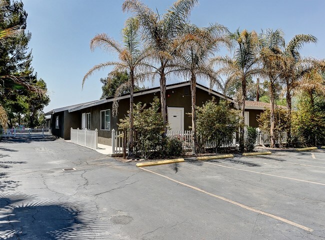
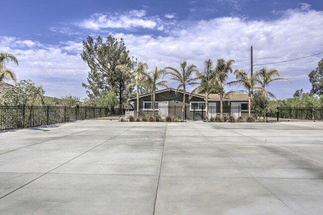
Property Record
15541 Sierra Hwy, Santa Clarita, CA 91390

NEARBY LISTINGS FOR SALE OR LEASE
Property Detail
15541 Sierra Hwy
Los Angeles-Long Beach-Glendale, CA
Los Angeles
2853-002-003
California
Sfr
4.91 AC
AE
Santa Clarita Valley
06037C0835G
Los Angeles
4,676 SF
DEMOGRAPHICS near 15541 Sierra Hwy
1 Mile
3 Mile
5 Mile
2024 Total Population
333
15,460
63,599
2029 Population
320
14,784
61,231
Pop Growth 2024-2029
(3.90%)
(4.37%)
(3.72%)
Average Age
42
40
38
2024 Total Households
102
4,788
19,761
HH Growth 2024-2029
(4.90%)
(4.62%)
(4.04%)
Median Household Inc
$91,847
$117,736
$102,355
Avg Household Size
3.10
3.20
3.10
2024 Avg HH Vehicles
3.00
3.00
2.00
Median Home Value
$750,000
$717,887
$687,105
Median Year Built
1978
1984
1987
Nearby Places
Map Layers
Map Styles
 Street
 Aerial
- Restaurants
- Banks
- Shops
- Fitness
- Groceries
PUBLIC TRANSPORTATION
COMMUTER RAIL
Via Princessa (Antelope Valley Line - Southern California Regional Rail Authority (Metrolink))
DRIVE
WALK
Distance
Via Princessa (Antelope Valley Line - Southern California Regional Rail Authority (Metrolink))
10 min
6.2 mi
Vista Canyon Metrolink Station (Metrolink Antelope Valley Line - Metrolink Trains)
DRIVE
WALK
Distance
Vista Canyon Metrolink Station (Metrolink Antelope Valley Line - Metrolink Trains)
13 min
7.0 mi
AIRPORT
Bob Hope
DRIVE
WALK
Distance
Bob Hope
34 min
26.0 mi
Freight Ports
Port of Long Beach
DRIVE
WALK
Distance
Port of Long Beach
77 min
62.4 mi
SALE & LEASE HISTORY
LISTING DATE
SALE/LEASE

Nov 17, 2020
For Sale
Nov 02, 2016
For Sale
Jul 12, 2018
For Sale
Nearby Properties
Address
Land Use
TOTAL SIZE
Lot Size
Zoning
Address
Land Use
TOTAL SIZE
Lot Size
Zoning
272,382 SF
35.44 AC
SCUR5
Address
Land Use
TOTAL SIZE
Lot Size
Zoning
38,308 SF
2.04 AC
SCCC
Address
Land Use
TOTAL SIZE
Lot Size
Zoning
96,666 SF
9.19 AC
SCBP
Address
Land Use
TOTAL SIZE
Lot Size
Zoning
18,900 SF
4.67 AC
LCM1*
Address
Land Use
TOTAL SIZE
Lot Size
Zoning
50,639 SF
3.50 AC
SCUR2
Address
Land Use
TOTAL SIZE
Lot Size
Zoning
165.83 AC
LCR1
Address
Land Use
TOTAL SIZE
Lot Size
Zoning
112.98 AC
LCA1
Address
Land Use
TOTAL SIZE
Lot Size
Zoning
43,605 SF
2.36 AC
SCUR2
Address
Land Use
TOTAL SIZE
Lot Size
Zoning
45,016 SF
2.56 AC
SCCC
Address
Land Use
TOTAL SIZE
Lot Size
Zoning
38,362 SF
2.07 AC
SCUR2
Address
Land Use
TOTAL SIZE
Lot Size
Zoning
840 SF
31.53 AC
LCC3-A11*
Address
Land Use
TOTAL SIZE
Lot Size
Zoning
148.76 AC
LCC3-A11-R
Address
Land Use
TOTAL SIZE
Lot Size
Zoning
24,966 SF
1.16 AC
SCCC
Address
Land Use
TOTAL SIZE
Lot Size
Zoning
24,700 SF
1.81 AC
SCUR3
Address
Land Use
TOTAL SIZE
Lot Size
Zoning
24,700 SF
1.29 AC
SCUR3
Address
Land Use
TOTAL SIZE
Lot Size
Zoning
38,308 SF
0.85 AC
SCCC
Address
Land Use
TOTAL SIZE
Lot Size
Zoning
6,740 SF
0.44 AC
SCCC
Address
Land Use
TOTAL SIZE
Lot Size
Zoning
Address
Land Use
TOTAL SIZE
Lot Size
Zoning
38,308 SF
0.39 AC
SCCC
Address
Land Use
TOTAL SIZE
Lot Size
Zoning
18,525 SF
1.69 AC
SCUR3
Address
Land Use
TOTAL SIZE
Lot Size
Zoning
3,780 SF
6.04 AC
SCCC
Address
Land Use
TOTAL SIZE
Lot Size
Zoning
976 SF
11.55 AC
LCM11/2*
Address
Land Use
TOTAL SIZE
Lot Size
Zoning
3,776 SF
0.58 AC
SCCC
Address
Land Use
TOTAL SIZE
Lot Size
Zoning
6,283 SF
0.62 AC
SCCC
Address
Land Use
TOTAL SIZE
Lot Size
Zoning
1,200 SF
7.45 AC
LCM1*
Address
Land Use
TOTAL SIZE
Lot Size
Zoning
11,424 SF
4.02 AC
LCM1*
Address
Land Use
TOTAL SIZE
Lot Size
Zoning
669 SF
2.52 AC
SCCC
Address
Land Use
TOTAL SIZE
Lot Size
Zoning
43,967 SF
40.97 AC
LCM11/2*
Address
Land Use
TOTAL SIZE
Lot Size
Zoning
12,350 SF
0.60 AC
SCUR3
The World's #1 Commercial Real Estate Marketplace
Connect with us
© 2026 CoStar Group
The information above has been obtained from sources believed reliable. While we do not doubt its accuracy we have not verified it and make no guarantee, warranty or representation about it. It is your responsibility to independently confirm its accuracy and completeness. Any projections, opinions, assumptions, or estimates used are for example only and do not represent the current or future performance of the property. The value of this transaction to you depends on tax and other factors which should be evaluated by your tax, financial, and legal advisors. You and your advisors should conduct a careful, independent investigation of the property to determine to your satisfaction the suitability of the property for your needs.