Property Record
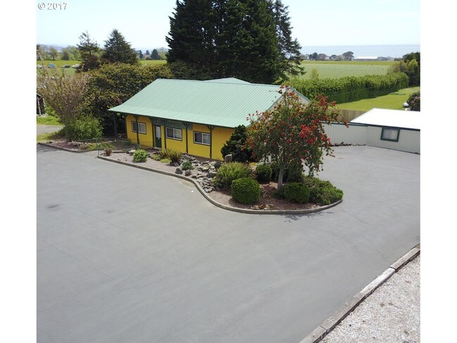
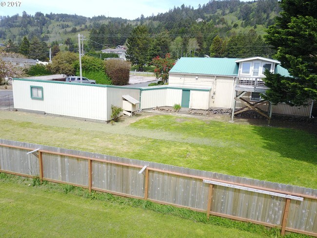
15542 Highway 101 S, Brookings, OR 97415

Property Detail
15542 Highway 101 S
R38058
P.P. 2013-02, PARCEL 1, ACRES 0.89
Commercialnec
CURRY
RC
Oregon
B and X Area of moderate flood hazard, usually the area between the limits of the 100-year and 500-year floods.
0.89 AC
2025
Oregon West Area
2025
Other Market Areas
950401
Brookings, OR
NEARBY LISTINGS FOR SALE OR LEASE
-
-
View all Brookings listings for sale on LoopNet.com
DEMOGRAPHICS near 15542 Highway 101 S
1 mile
3 mile
5 mile
2025 Total Population
1,311
7,342
12,688
2030 Population
1,297
7,099
12,305
Pop Growth 2025-2030
(1.07%)
(3.31%)
(3.02%)
Average Age
57
52
50
2025 Total Households
639
3,515
5,855
HH Growth 2025-2030
(1.25%)
(3.41%)
(3.11%)
Median Household Inc
$67,894
$62,895
$67,239
Avg Household Size
2.10
2.00
2.10
2025 Avg HH Vehicles
2.00
2.00
2.00
Median Home Value
$457,861
$397,462
$425,706
Median Year Built
1991
1984
1987
Nearby Places
Map Layers
Map Styles
 Street
 Aerial
Layers
 Traffic
 Biking
Places
Listings with unknown addresses are not visible on the map
- Restaurants
- Banks
- Shops
- Fitness
- Groceries
SALE & LEASE HISTORY
LISTING DATE
SALE/LEASE

Oct 11, 2017
For Sale
Nearby Properties
Address
Land Use
TOTAL SIZE
Lot Size
Zoning
Address
Land Use
TOTAL SIZE
Lot Size
Zoning
17.11 AC
M2
Address
Land Use
TOTAL SIZE
Lot Size
Zoning
109,521 SF
5.33 AC
C1
Address
Land Use
TOTAL SIZE
Lot Size
Zoning
17.11 AC
C3
Address
Land Use
TOTAL SIZE
Lot Size
Zoning
81,536 SF
2.85 AC
C1
Address
Land Use
TOTAL SIZE
Lot Size
Zoning
42,933 SF
1.91 AC
C1
Address
Land Use
TOTAL SIZE
Lot Size
Zoning
10.67 AC
M2
Address
Land Use
TOTAL SIZE
Lot Size
Zoning
8,520 SF
5.17 AC
C2
Address
Land Use
TOTAL SIZE
Lot Size
Zoning
74,904 SF
5.94 AC
C1
Address
Land Use
TOTAL SIZE
Lot Size
Zoning
1.38 AC
C3
Address
Land Use
TOTAL SIZE
Lot Size
Zoning
126,042 SF
4.88 AC
C1
Address
Land Use
TOTAL SIZE
Lot Size
Zoning
17.11 AC
M2
Address
Land Use
TOTAL SIZE
Lot Size
Zoning
1.67 AC
R3
Address
Land Use
TOTAL SIZE
Lot Size
Zoning
13,168 SF
2.43 AC
C1
Address
Land Use
TOTAL SIZE
Lot Size
Zoning
646 SF
8.19 AC
C1
Address
Land Use
TOTAL SIZE
Lot Size
Zoning
1,820 SF
1.35 AC
C3
Address
Land Use
TOTAL SIZE
Lot Size
Zoning
1,560 SF
5.15 AC
R-C
Address
Land Use
TOTAL SIZE
Lot Size
Zoning
2.11 AC
R3
Address
Land Use
TOTAL SIZE
Lot Size
Zoning
1.80 AC
PO-1
Address
Land Use
TOTAL SIZE
Lot Size
Zoning
45,956 SF
4.09 AC
RC
Address
Land Use
TOTAL SIZE
Lot Size
Zoning
11,472 SF
0.71 AC
C2
Address
Land Use
TOTAL SIZE
Lot Size
Zoning
23,801 SF
4.22 AC
RC
Address
Land Use
TOTAL SIZE
Lot Size
Zoning
2.57 AC
C3
Address
Land Use
TOTAL SIZE
Lot Size
Zoning
2.65 AC
R3
Address
Land Use
TOTAL SIZE
Lot Size
Zoning
10,735 SF
0.33 AC
C3
Address
Land Use
TOTAL SIZE
Lot Size
Zoning
1,248 SF
20.78 AC
RRC
Address
Land Use
TOTAL SIZE
Lot Size
Zoning
2,424 SF
9.53 AC
R3
Address
Land Use
TOTAL SIZE
Lot Size
Zoning
0.90 AC
C1
Address
Land Use
TOTAL SIZE
Lot Size
Zoning
2.91 AC
C1
Address
Land Use
TOTAL SIZE
Lot Size
Zoning
12,284 SF
0.54 AC
C3
The World's #1 Commercial Real Estate Marketplace
Connect with us
© 2026 CoStar Group
The information above has been obtained from sources believed reliable. While we do not doubt its accuracy we have not verified it and make no guarantee, warranty or representation about it. It is your responsibility to independently confirm its accuracy and completeness. Any projections, opinions, assumptions, or estimates used are for example only and do not represent the current or future performance of the property. The value of this transaction to you depends on tax and other factors which should be evaluated by your tax, financial, and legal advisors. You and your advisors should conduct a careful, independent investigation of the property to determine to your satisfaction the suitability of the property for your needs.