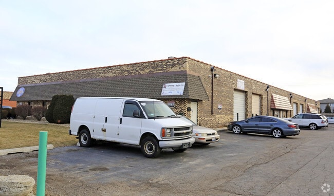
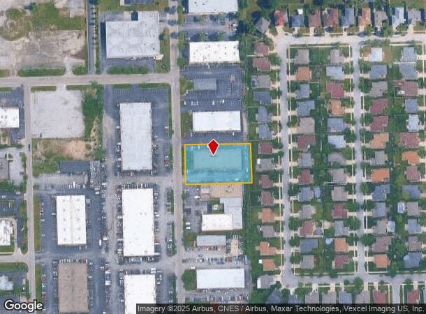
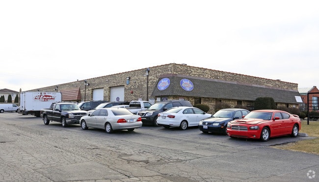
Property Record
15549 S 70Th Ct, Orland Park, IL 60462
Current Lease Availabilities
NEARBY LISTINGS FOR SALE OR LEASE
-
-
View all Orland Park listings for lease on LoopNet.com
Property Detail
15549 S 70Th Ct
28-18-310-011-0000
Commercial & Indl Sub/Catalin
Industrialgeneral
Cook
X
Illinois
17031C0706J
111,1
2023
1.06 AC
2024
Near South Cook
824508
Chicago
16,000 SF
Chicago-Naperville-Elgin, IL-IN-WI
DEMOGRAPHICS near 15549 S 70Th Ct
1 Mile
3 Mile
5 Mile
2024 Total Population
10,747
87,761
198,995
2029 Population
10,367
85,014
193,988
Pop Growth 2024-2029
(3.54%)
(3.13%)
(2.52%)
Average Age
44
42
43
2024 Total Households
4,447
34,140
76,418
HH Growth 2024-2029
(3.80%)
(3.44%)
(2.79%)
Median Household Inc
$74,918
$84,093
$82,440
Avg Household Size
2.40
2.50
2.50
2024 Avg HH Vehicles
2.00
2.00
2.00
Median Home Value
$242,801
$257,090
$256,253
Median Year Built
1978
1979
1979
Nearby Places
- Restaurants
- Banks
- Shops
- Fitness
- Groceries
PUBLIC TRANSPORTATION
COMMUTER RAIL
Tinley Park Station (Rock Island District Line - Northeast Illinois Regional Commuter Railroad (Metra))
DRIVE
WALK
Distance
Tinley Park Station (Rock Island District Line - Northeast Illinois Regional Commuter Railroad (Metra))
8 min
3.1 mi
Oak Forest Station (Rock Island District Line - Northeast Illinois Regional Commuter Railroad (Metra))
DRIVE
WALK
Distance
Oak Forest Station (Rock Island District Line - Northeast Illinois Regional Commuter Railroad (Metra))
8 min
4.0 mi
AIRPORT
Chicago Midway International
DRIVE
WALK
Distance
Chicago Midway International
25 min
14.6 mi
Chicago O'Hare International
DRIVE
WALK
Distance
Chicago O'Hare International
67 min
33.7 mi
Nearby Properties
Address
Land Use
TOTAL SIZE
Lot Size
Zoning
Address
Land Use
TOTAL SIZE
Lot Size
Zoning
266,729 SF
20.64 AC
Address
Land Use
TOTAL SIZE
Lot Size
Zoning
6.16 AC
Address
Land Use
TOTAL SIZE
Lot Size
Zoning
132,193 SF
16.49 AC
Address
Land Use
TOTAL SIZE
Lot Size
Zoning
Address
Land Use
TOTAL SIZE
Lot Size
Zoning
114,484 SF
14.88 AC
Address
Land Use
TOTAL SIZE
Lot Size
Zoning
273,000 SF
20.69 AC
Address
Land Use
TOTAL SIZE
Lot Size
Zoning
203,359 SF
12.56 AC
Address
Land Use
TOTAL SIZE
Lot Size
Zoning
208,523 SF
7.05 AC
Address
Land Use
TOTAL SIZE
Lot Size
Zoning
74,992 SF
3.62 AC
Address
Land Use
TOTAL SIZE
Lot Size
Zoning
17.50 AC
Address
Land Use
TOTAL SIZE
Lot Size
Zoning
47,125 SF
5.85 AC
Address
Land Use
TOTAL SIZE
Lot Size
Zoning
124,846 SF
Address
Land Use
TOTAL SIZE
Lot Size
Zoning
110,590 SF
10.30 AC
Address
Land Use
TOTAL SIZE
Lot Size
Zoning
92,955 SF
12.33 AC
Address
Land Use
TOTAL SIZE
Lot Size
Zoning
85,290 SF
9.25 AC
Address
Land Use
TOTAL SIZE
Lot Size
Zoning
72,935 SF
2.90 AC
Address
Land Use
TOTAL SIZE
Lot Size
Zoning
202,591 SF
16.29 AC
Address
Land Use
TOTAL SIZE
Lot Size
Zoning
59,948 SF
5.02 AC
Address
Land Use
TOTAL SIZE
Lot Size
Zoning
79,625 SF
3.89 AC
Address
Land Use
TOTAL SIZE
Lot Size
Zoning
53,768 SF
3.91 AC
Address
Land Use
TOTAL SIZE
Lot Size
Zoning
3.87 AC
Address
Land Use
TOTAL SIZE
Lot Size
Zoning
125,337 SF
11.57 AC
Address
Land Use
TOTAL SIZE
Lot Size
Zoning
61,641 SF
6.84 AC
Address
Land Use
TOTAL SIZE
Lot Size
Zoning
9.28 AC
Address
Land Use
TOTAL SIZE
Lot Size
Zoning
79,931 SF
1.91 AC
Address
Land Use
TOTAL SIZE
Lot Size
Zoning
1.38 AC
Address
Land Use
TOTAL SIZE
Lot Size
Zoning
28,519 SF
0.90 AC
Address
Land Use
TOTAL SIZE
Lot Size
Zoning
66,004 SF
7.47 AC
Address
Land Use
TOTAL SIZE
Lot Size
Zoning
123,329 SF
6.28 AC
Address
Land Use
TOTAL SIZE
Lot Size
Zoning
80,723 SF
2.47 AC
The World's #1 Commercial Real Estate Marketplace
Connect with us
© 2025 CoStar Group
The information above has been obtained from sources believed reliable. While we do not doubt its accuracy we have not verified it and make no guarantee, warranty or representation about it. It is your responsibility to independently confirm its accuracy and completeness. Any projections, opinions, assumptions, or estimates used are for example only and do not represent the current or future performance of the property. The value of this transaction to you depends on tax and other factors which should be evaluated by your tax, financial, and legal advisors. You and your advisors should conduct a careful, independent investigation of the property to determine to your satisfaction the suitability of the property for your needs.