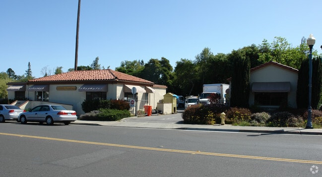
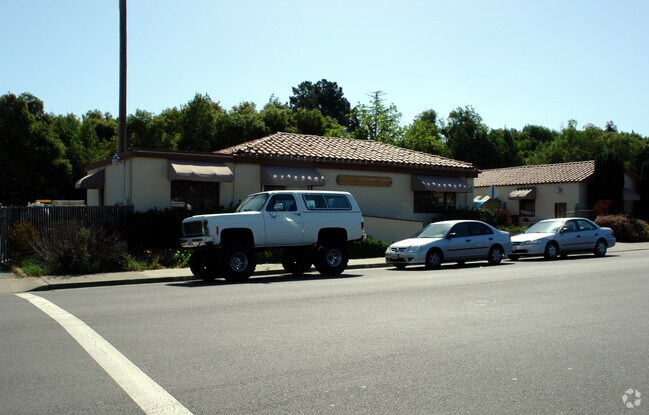
Property Record
1555 Miramonte Ave, Los Altos, CA 94024

Property Detail
1555 Miramonte Ave
193-40-043
Santa Clara
Utilities
California
CN
0.56 AC
AE The base floodplain where base flood elevations are provided. AE Zones are now used on new format FIRMs instead of A1-A30 Zones.
Los Altos
2024
South Bay/San Jose
2025
San Jose-Sunnyvale-Santa Clara, CA
510001
NEARBY LISTINGS FOR SALE OR LEASE
DEMOGRAPHICS near 1555 Miramonte Ave
1 mile
3 mile
5 mile
2025 Total Population
12,763
135,456
355,287
2030 Population
13,023
138,900
366,132
Pop Growth 2025-2030
+ 2.04%
+ 2.54%
+ 3.05%
Average Age
45
41
40
2025 Total Households
4,221
49,530
133,369
HH Growth 2025-2030
+ 2.04%
+ 2.61%
+ 3.14%
Median Household Inc
$256,331
$209,155
$198,205
Avg Household Size
2.90
2.70
2.60
2025 Avg HH Vehicles
2.00
2.00
2.00
Median Home Value
$1,143,672
$1,136,382
$1,132,027
Median Year Built
1961
1968
1972
Nearby Places
Map Layers
Map Styles
 Street
 Aerial
Layers
 Traffic
 Biking
Places
Listings with unknown addresses are not visible on the map
- Restaurants
- Banks
- Shops
- Fitness
- Groceries
PUBLIC TRANSPORTATION
COMMUTER RAIL
Mountain View Caltrain Station Southbound (Express - Caltrain (Caltrain), Limited - Caltrain (Caltrain), Local Weekday - Caltrain (Caltrain), Local Weekend - Caltrain (Caltrain))
Drive
Walk
Distance
Mountain View Caltrain Station Southbound (Express - Caltrain (Caltrain), Limited - Caltrain (Caltrain), Local Weekday - Caltrain (Caltrain), Local Weekend - Caltrain (Caltrain))
9 min
3.2 mi
Sunnyvale Caltrain Station Southbound (Express - Caltrain (Caltrain), Limited - Caltrain (Caltrain), Local Weekday - Caltrain (Caltrain), Local Weekend - Caltrain (Caltrain))
Drive
Walk
Distance
Sunnyvale Caltrain Station Southbound (Express - Caltrain (Caltrain), Limited - Caltrain (Caltrain), Local Weekday - Caltrain (Caltrain), Local Weekend - Caltrain (Caltrain))
12 min
5.1 mi
AIRPORT
Norman Y Mineta San Jose International
Drive
Walk
Distance
Norman Y Mineta San Jose International
20 min
11.9 mi
San Francisco International
Drive
Walk
Distance
San Francisco International
39 min
29.9 mi
Metro Oakland International
Drive
Walk
Distance
Metro Oakland International
52 min
38.6 mi
Freight Ports
Port of Redwood City
Drive
Walk
Distance
Port of Redwood City
24 min
16.7 mi
Nearby Properties
Address
Land Use
TOTAL SIZE
Lot Size
Zoning
Address
Land Use
TOTAL SIZE
Lot Size
Zoning
42.28 AC
PF
Address
Land Use
TOTAL SIZE
Lot Size
Zoning
0.33 AC
PF
Address
Land Use
TOTAL SIZE
Lot Size
Zoning
298,463 SF
7 AC
P(19)
Address
Land Use
TOTAL SIZE
Lot Size
Zoning
381,064 SF
20.42 AC
R322
Address
Land Use
TOTAL SIZE
Lot Size
Zoning
266,088 SF
16.20 AC
P(29)
Address
Land Use
TOTAL SIZE
Lot Size
Zoning
266,600 SF
2.97 AC
P(30)
Address
Land Use
TOTAL SIZE
Lot Size
Zoning
295,262 SF
2.24 AC
P(30)
Address
Land Use
TOTAL SIZE
Lot Size
Zoning
96,579 SF
1.21 AC
P(19)
Address
Land Use
TOTAL SIZE
Lot Size
Zoning
186,490 SF
2.43 AC
CRA
Address
Land Use
TOTAL SIZE
Lot Size
Zoning
114,809 SF
3.94 AC
P18
Address
Land Use
TOTAL SIZE
Lot Size
Zoning
111,726 SF
1.57 AC
P-19
Address
Land Use
TOTAL SIZE
Lot Size
Zoning
133,631 SF
4.12 AC
C2
Address
Land Use
TOTAL SIZE
Lot Size
Zoning
171,170 SF
11.82 AC
P(17)
Address
Land Use
TOTAL SIZE
Lot Size
Zoning
226,101 SF
2.85 AC
CRA
Address
Land Use
TOTAL SIZE
Lot Size
Zoning
76.50 AC
A-D1
Address
Land Use
TOTAL SIZE
Lot Size
Zoning
174,723 SF
2.30 AC
P(38)
Address
Land Use
TOTAL SIZE
Lot Size
Zoning
12.81 AC
APD
Address
Land Use
TOTAL SIZE
Lot Size
Zoning
163,422 SF
6.95 AC
R3
Address
Land Use
TOTAL SIZE
Lot Size
Zoning
1.66 AC
P(19)
Address
Land Use
TOTAL SIZE
Lot Size
Zoning
0.01 AC
P(30)
Address
Land Use
TOTAL SIZE
Lot Size
Zoning
151,127 SF
1.25 AC
CD
Address
Land Use
TOTAL SIZE
Lot Size
Zoning
176,296 SF
1.58 AC
P(19)
Address
Land Use
TOTAL SIZE
Lot Size
Zoning
188,266 SF
1.92 AC
P38
Address
Land Use
TOTAL SIZE
Lot Size
Zoning
106,460 SF
7.74 AC
ML
Address
Land Use
TOTAL SIZE
Lot Size
Zoning
328,292 SF
19.72 AC
R322
Address
Land Use
TOTAL SIZE
Lot Size
Zoning
80,000 SF
4.64 AC
0/ITR
Address
Land Use
TOTAL SIZE
Lot Size
Zoning
4.45 AC
CU
Address
Land Use
TOTAL SIZE
Lot Size
Zoning
68,121 SF
1.13 AC
P(19)
Address
Land Use
TOTAL SIZE
Lot Size
Zoning
0.34 AC
R1-7.
Address
Land Use
TOTAL SIZE
Lot Size
Zoning
0.01 AC
P(30)
The World's #1 Commercial Real Estate Marketplace
Connect with us
© 2026 CoStar Group
The information above has been obtained from sources believed reliable. While we do not doubt its accuracy we have not verified it and make no guarantee, warranty or representation about it. It is your responsibility to independently confirm its accuracy and completeness. Any projections, opinions, assumptions, or estimates used are for example only and do not represent the current or future performance of the property. The value of this transaction to you depends on tax and other factors which should be evaluated by your tax, financial, and legal advisors. You and your advisors should conduct a careful, independent investigation of the property to determine to your satisfaction the suitability of the property for your needs.