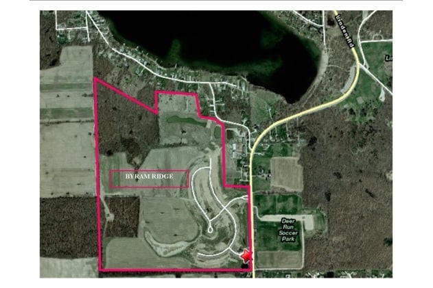
Property Record
15550 Linden Rd, Linden, MI 48451
Property Detail
15550 Linden Rd
Flint, MI
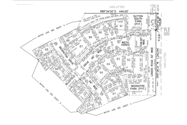
LOT 3 BYRAM RIDGE NO 1 (07) FR 0631200006
06-30-400-041
GENESEE
Agriculturalland
Michigan
PUD
3
B and X Area of moderate flood hazard, usually the area between the limits of the 100-year and 500-year floods.
124.44 AC
2025
Flint
2025
Detroit
013112
NEARBY LISTINGS FOR SALE OR LEASE
DEMOGRAPHICS near 15550 Linden Rd
1 mile
3 mile
5 mile
2025 Total Population
2,135
18,397
41,156
2030 Population
2,130
18,226
40,809
Pop Growth 2025-2030
(0.23%)
(0.93%)
(0.84%)
Average Age
41
43
43
2025 Total Households
756
7,188
16,398
HH Growth 2025-2030
(0.26%)
(1.03%)
(0.91%)
Median Household Inc
$115,077
$95,592
$95,836
Avg Household Size
2.70
2.50
2.50
2025 Avg HH Vehicles
2.00
2.00
2.00
Median Home Value
$316,889
$314,499
$308,481
Median Year Built
1992
1990
1986
Nearby Places
Map Layers
Map Styles
 Street
 Aerial
Layers
 Traffic
 Biking
Places
Listings with unknown addresses are not visible on the map
- Restaurants
- Banks
- Shops
- Fitness
- Groceries
PUBLIC TRANSPORTATION
AIRPORT
Bishop International
Drive
Walk
Distance
Bishop International
36 min
18.1 mi
Freight Ports
Port of Toledo
Drive
Walk
Distance
Port of Toledo
124 min
98.7 mi
Nearby Properties
Address
Land Use
TOTAL SIZE
Lot Size
Zoning
Address
Land Use
TOTAL SIZE
Lot Size
Zoning
215,494 SF
25.02 AC
GBD
Address
Land Use
TOTAL SIZE
Lot Size
Zoning
162,144 SF
8 AC
PUD
Address
Land Use
TOTAL SIZE
Lot Size
Zoning
82,447 SF
8.96 AC
GBD
Address
Land Use
TOTAL SIZE
Lot Size
Zoning
92,006 SF
7.89 AC
R-3
Address
Land Use
TOTAL SIZE
Lot Size
Zoning
148,951 SF
10.02 AC
HDR
Address
Land Use
TOTAL SIZE
Lot Size
Zoning
87,847 SF
12.71 AC
GBD
Address
Land Use
TOTAL SIZE
Lot Size
Zoning
63,504 SF
8.26 AC
PUD
Address
Land Use
TOTAL SIZE
Lot Size
Zoning
145,076 SF
11.95 AC
HDR
Address
Land Use
TOTAL SIZE
Lot Size
Zoning
3,380 SF
152.79 AC
R-5
Address
Land Use
TOTAL SIZE
Lot Size
Zoning
8,902 SF
233.33 AC
RE
Address
Land Use
TOTAL SIZE
Lot Size
Zoning
26,719 SF
4.07 AC
GBD
Address
Land Use
TOTAL SIZE
Lot Size
Zoning
19,650 SF
2.70 AC
GBD
Address
Land Use
TOTAL SIZE
Lot Size
Zoning
3,558 SF
10.01 AC
AG
Address
Land Use
TOTAL SIZE
Lot Size
Zoning
25,735 SF
4.46 AC
GBD
Address
Land Use
TOTAL SIZE
Lot Size
Zoning
47 AC
SEVERAL
Address
Land Use
TOTAL SIZE
Lot Size
Zoning
24.50 AC
R-3
Address
Land Use
TOTAL SIZE
Lot Size
Zoning
23,627 SF
3.38 AC
GBD
Address
Land Use
TOTAL SIZE
Lot Size
Zoning
37,018 SF
7.65 AC
GC
Address
Land Use
TOTAL SIZE
Lot Size
Zoning
8,026 SF
2.77 AC
GBD
Address
Land Use
TOTAL SIZE
Lot Size
Zoning
14,784 SF
0.22 AC
Address
Land Use
TOTAL SIZE
Lot Size
Zoning
63,145 SF
8.90 AC
C-2
Address
Land Use
TOTAL SIZE
Lot Size
Zoning
2,320 SF
157.41 AC
RE
Address
Land Use
TOTAL SIZE
Lot Size
Zoning
11,328 SF
1.25 AC
OSD
Address
Land Use
TOTAL SIZE
Lot Size
Zoning
26,796 SF
160 AC
R-1
Address
Land Use
TOTAL SIZE
Lot Size
Zoning
4,477 SF
1.49 AC
GBD
Address
Land Use
TOTAL SIZE
Lot Size
Zoning
5,957 SF
1.36 AC
GBD
Address
Land Use
TOTAL SIZE
Lot Size
Zoning
42,225 SF
5.60 AC
COMM
Address
Land Use
TOTAL SIZE
Lot Size
Zoning
6,308 SF
3.22 AC
GBD
Address
Land Use
TOTAL SIZE
Lot Size
Zoning
10,856 SF
1.30 AC
GBD
Address
Land Use
TOTAL SIZE
Lot Size
Zoning
26,984 SF
3.53 AC
R-4
The World's #1 Commercial Real Estate Marketplace
Connect with us
© 2026 CoStar Group
The information above has been obtained from sources believed reliable. While we do not doubt its accuracy we have not verified it and make no guarantee, warranty or representation about it. It is your responsibility to independently confirm its accuracy and completeness. Any projections, opinions, assumptions, or estimates used are for example only and do not represent the current or future performance of the property. The value of this transaction to you depends on tax and other factors which should be evaluated by your tax, financial, and legal advisors. You and your advisors should conduct a careful, independent investigation of the property to determine to your satisfaction the suitability of the property for your needs.