Property Record
15550 Neabsco Mills Rd, Woodbridge, VA 22191
NEARBY LISTINGS FOR SALE OR LEASE
Property Detail
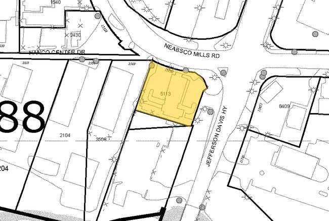
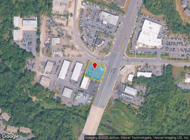
15550 Neabsco Mills Rd
Washington-Arlington-Alexandria, DC-VA-MD-WV
ROUTE 1 NORTH 15550 NEABSCO MILLS RD
8290-88-4911
Prince William
Servicestationmarket
Virginia
2024
5113
2025
0.58 AC
900410
Woodbridge/I-95 Corridor
2,486 SF
Washington, DC
DEMOGRAPHICS near 15550 Neabsco Mills Rd
1 Mile
3 Mile
5 Mile
2024 Total Population
12,705
104,099
213,363
2029 Population
13,018
107,004
219,195
Pop Growth 2024-2029
+ 2.46%
+ 2.79%
+ 2.73%
Average Age
35
36
36
2024 Total Households
4,531
33,497
68,592
HH Growth 2024-2029
+ 2.49%
+ 2.82%
+ 2.77%
Median Household Inc
$116,647
$101,148
$105,463
Avg Household Size
2.70
3.00
3.00
2024 Avg HH Vehicles
2.00
2.00
2.00
Median Home Value
$430,672
$391,141
$395,650
Median Year Built
2007
1995
1989
Nearby Places
Map Layers
Map Styles
 Street
 Aerial
- Restaurants
- Banks
- Shops
- Fitness
- Groceries
PUBLIC TRANSPORTATION
COMMUTER RAIL
Rippon (Fredericksburg Line - Virginia Railway Express)
DRIVE
WALK
Distance
Rippon (Fredericksburg Line - Virginia Railway Express)
6 min
3.0 mi
Woodbridge (Fredericksburg Line - Virginia Railway Express)
DRIVE
WALK
Distance
Woodbridge (Fredericksburg Line - Virginia Railway Express)
8 min
4.1 mi
AIRPORT
Ronald Reagan Washington Ntl
DRIVE
WALK
Distance
Ronald Reagan Washington Ntl
38 min
24.9 mi
Washington Dulles International
DRIVE
WALK
Distance
Washington Dulles International
59 min
33.8 mi
Freight Ports
Port of Baltimore
DRIVE
WALK
Distance
Port of Baltimore
96 min
66.0 mi
Nearby Properties
Address
Land Use
TOTAL SIZE
Lot Size
Zoning
Address
Land Use
TOTAL SIZE
Lot Size
Zoning
1,402,177 SF
104.72 AC
B1
Address
Land Use
TOTAL SIZE
Lot Size
Zoning
570,195 SF
38.70 AC
OH
Address
Land Use
TOTAL SIZE
Lot Size
Zoning
485,714 SF
82.68 AC
MIXED
Address
Land Use
TOTAL SIZE
Lot Size
Zoning
660,280 SF
10.80 AC
RPC
Address
Land Use
TOTAL SIZE
Lot Size
Zoning
872,283 SF
17.34 AC
PMR
Address
Land Use
TOTAL SIZE
Lot Size
Zoning
527,268 SF
114.14 AC
A1
Address
Land Use
TOTAL SIZE
Lot Size
Zoning
345,910 SF
18.78 AC
PMR
Address
Land Use
TOTAL SIZE
Lot Size
Zoning
337,789 SF
10.02 AC
PMD
Address
Land Use
TOTAL SIZE
Lot Size
Zoning
382,173 SF
91.53 AC
A1
Address
Land Use
TOTAL SIZE
Lot Size
Zoning
81,628 SF
26.25 AC
R16
Address
Land Use
TOTAL SIZE
Lot Size
Zoning
338,574 SF
13.09 AC
R16
Address
Land Use
TOTAL SIZE
Lot Size
Zoning
189,313 SF
18.44 AC
R16
Address
Land Use
TOTAL SIZE
Lot Size
Zoning
139,974 SF
15.27 AC
R16
Address
Land Use
TOTAL SIZE
Lot Size
Zoning
316,829 SF
8.96 AC
PMR
Address
Land Use
TOTAL SIZE
Lot Size
Zoning
220,769 SF
105.55 AC
MIXED
Address
Land Use
TOTAL SIZE
Lot Size
Zoning
281,041 SF
76.93 AC
MIXED
Address
Land Use
TOTAL SIZE
Lot Size
Zoning
356,211 SF
7.34 AC
RPC
Address
Land Use
TOTAL SIZE
Lot Size
Zoning
354,638 SF
28.32 AC
B1
Address
Land Use
TOTAL SIZE
Lot Size
Zoning
338,286 SF
28.64 AC
R16
Address
Land Use
TOTAL SIZE
Lot Size
Zoning
176,134 SF
16.06 AC
R16
Address
Land Use
TOTAL SIZE
Lot Size
Zoning
252,614 SF
21.96 AC
B1
Address
Land Use
TOTAL SIZE
Lot Size
Zoning
434,095 SF
18.64 AC
B1
Address
Land Use
TOTAL SIZE
Lot Size
Zoning
24,695 SF
16.11 AC
RPC
Address
Land Use
TOTAL SIZE
Lot Size
Zoning
223,340 SF
20.64 AC
MIXED
Address
Land Use
TOTAL SIZE
Lot Size
Zoning
282,041 SF
9.77 AC
PMR
Address
Land Use
TOTAL SIZE
Lot Size
Zoning
106,159 SF
21.36 AC
PMR
Address
Land Use
TOTAL SIZE
Lot Size
Zoning
170,328 SF
13.21 AC
R16
Address
Land Use
TOTAL SIZE
Lot Size
Zoning
83,208 SF
22.93 AC
R16
Address
Land Use
TOTAL SIZE
Lot Size
Zoning
120,203 SF
17.35 AC
MIXED
Address
Land Use
TOTAL SIZE
Lot Size
Zoning
50,855 SF
11.77 AC
R16
The World's #1 Commercial Real Estate Marketplace
Connect with us
© 2025 CoStar Group
The information above has been obtained from sources believed reliable. While we do not doubt its accuracy we have not verified it and make no guarantee, warranty or representation about it. It is your responsibility to independently confirm its accuracy and completeness. Any projections, opinions, assumptions, or estimates used are for example only and do not represent the current or future performance of the property. The value of this transaction to you depends on tax and other factors which should be evaluated by your tax, financial, and legal advisors. You and your advisors should conduct a careful, independent investigation of the property to determine to your satisfaction the suitability of the property for your needs.