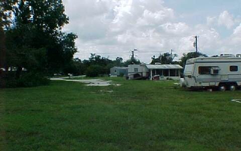
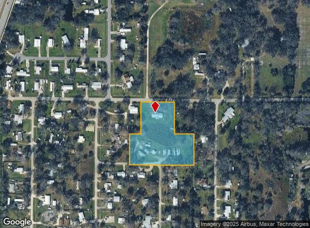
Property Record
1557 Sw Skates St, Arcadia, FL 34266
NEARBY LISTINGS FOR SALE OR LEASE
Property Detail
1557 Sw Skates St
13-38-24-0000-0760-0000
BEG NE COR OF NE1/4 OF NW1/4 TH S 220 FT FOR POB TH CONT S 214.76 FT TH W 439.38 FT TH N 285.68 FT TH E 75 FT TH N 150 FT TH E 255 FT TH S 220 FT TH E 109.18 FT TO POB LESS RDS ON S & N & LESS BEG NE COR OF NE1/4 OF NW1/4 TH W 439.18 FT TH S 150 FT T
Parkinglot
DeSoto
A
Florida
12027C0186C
3 AC
2024
Florida Central South Area
2024
Other Market Areas
010301
Arcadia, FL
2,307 SF
DEMOGRAPHICS near 1557 Sw Skates St
1 Mile
3 Mile
5 Mile
2024 Total Population
1,624
14,776
23,782
2029 Population
1,816
16,332
26,255
Pop Growth 2024-2029
+ 11.82%
+ 10.53%
+ 10.40%
Average Age
35
37
39
2024 Total Households
523
4,914
8,145
HH Growth 2024-2029
+ 12.81%
+ 11.58%
+ 11.39%
Median Household Inc
$38,249
$33,918
$34,694
Avg Household Size
3.10
2.90
2.80
2024 Avg HH Vehicles
2.00
2.00
2.00
Median Home Value
$91,357
$112,963
$117,287
Median Year Built
1980
1980
1983
Nearby Places
Map Layers
Map Styles
 Street
 Aerial
- Restaurants
- Banks
- Shops
- Fitness
- Groceries
PUBLIC TRANSPORTATION
AIRPORT
Punta Gorda
DRIVE
WALK
Distance
Punta Gorda
33 min
22.9 mi
Freight Ports
Port Manatee
DRIVE
WALK
Distance
Port Manatee
84 min
60.7 mi
Nearby Properties
Address
Land Use
TOTAL SIZE
Lot Size
Zoning
Address
Land Use
TOTAL SIZE
Lot Size
Zoning
67,387 SF
46.10 AC
PUD
Address
Land Use
TOTAL SIZE
Lot Size
Zoning
57,048 SF
20.25 AC
PUD
Address
Land Use
TOTAL SIZE
Lot Size
Zoning
67,970 SF
8.24 AC
CG
Address
Land Use
TOTAL SIZE
Lot Size
Zoning
121,889 SF
9 AC
B-3
Address
Land Use
TOTAL SIZE
Lot Size
Zoning
83,273 SF
13.94 AC
ROI
Address
Land Use
TOTAL SIZE
Lot Size
Zoning
25,798 SF
5 AC
B-1A
Address
Land Use
TOTAL SIZE
Lot Size
Zoning
80,103 SF
11 AC
R-1B
Address
Land Use
TOTAL SIZE
Lot Size
Zoning
45,985 SF
1.30 AC
B-2
Address
Land Use
TOTAL SIZE
Lot Size
Zoning
40,614 SF
4.33 AC
R-3
Address
Land Use
TOTAL SIZE
Lot Size
Zoning
41,004 SF
4.67 AC
R-3
Address
Land Use
TOTAL SIZE
Lot Size
Zoning
27,816 SF
3.67 AC
RMF-8
Address
Land Use
TOTAL SIZE
Lot Size
Zoning
48,488 SF
3.24 AC
B-2
Address
Land Use
TOTAL SIZE
Lot Size
Zoning
97,755 SF
9.20 AC
PUD
Address
Land Use
TOTAL SIZE
Lot Size
Zoning
21,108 SF
3.36 AC
A-5
Address
Land Use
TOTAL SIZE
Lot Size
Zoning
20,008 SF
4.69 AC
A-5
Address
Land Use
TOTAL SIZE
Lot Size
Zoning
40,470 SF
3.99 AC
CG
Address
Land Use
TOTAL SIZE
Lot Size
Zoning
13,509 SF
1.93 AC
CG
Address
Land Use
TOTAL SIZE
Lot Size
Zoning
26,360 SF
1.80 AC
P-1
Address
Land Use
TOTAL SIZE
Lot Size
Zoning
59,064 SF
7 AC
RSF-3
Address
Land Use
TOTAL SIZE
Lot Size
Zoning
66,888 SF
11.95 AC
RMF-12
Address
Land Use
TOTAL SIZE
Lot Size
Zoning
28,744 SF
2.94 AC
B-1A
Address
Land Use
TOTAL SIZE
Lot Size
Zoning
54,640 SF
6.21 AC
CG
Address
Land Use
TOTAL SIZE
Lot Size
Zoning
4.70 AC
CG
Address
Land Use
TOTAL SIZE
Lot Size
Zoning
39,000 SF
3.43 AC
B-3
Address
Land Use
TOTAL SIZE
Lot Size
Zoning
32,087 SF
2.54 AC
R-1B
Address
Land Use
TOTAL SIZE
Lot Size
Zoning
2.21 AC
CG
Address
Land Use
TOTAL SIZE
Lot Size
Zoning
30,451 SF
2.41 AC
P-1
Address
Land Use
TOTAL SIZE
Lot Size
Zoning
1,368 SF
16.90 AC
MHP
Address
Land Use
TOTAL SIZE
Lot Size
Zoning
32,457 SF
4.25 AC
R-1B
Address
Land Use
TOTAL SIZE
Lot Size
Zoning
The World's #1 Commercial Real Estate Marketplace
Connect with us
© 2025 CoStar Group
The information above has been obtained from sources believed reliable. While we do not doubt its accuracy we have not verified it and make no guarantee, warranty or representation about it. It is your responsibility to independently confirm its accuracy and completeness. Any projections, opinions, assumptions, or estimates used are for example only and do not represent the current or future performance of the property. The value of this transaction to you depends on tax and other factors which should be evaluated by your tax, financial, and legal advisors. You and your advisors should conduct a careful, independent investigation of the property to determine to your satisfaction the suitability of the property for your needs.