Property Record
15571 Plank Rd, Baker, LA 70714
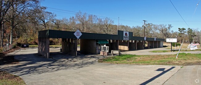

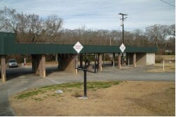
Property Detail
15571 Plank Rd
Baton Rouge, LA
WARD: 2-1, SUBDIVISION: GREENSBURG LAND DISTRICT, LOT: C. LOT C RESUBDIV. OF A 4.54 ACRETRACT. LOCATED IN SEC. 28 & 29, T5S,
01205501
E BATON ROUGE
Storesoffices
Louisiana
AE The base floodplain where base flood elevations are provided. AE Zones are now used on new format FIRMs instead of A1-A30 Zones.
c
2025
4.54 AC
2025
Greater Baton Rouge N
0042043003
Baton Rouge
NEARBY LISTINGS FOR SALE OR LEASE
DEMOGRAPHICS near 15571 Plank Rd
1 mile
3 mile
5 mile
2025 Total Population
2,075
18,092
47,496
2030 Population
2,063
17,968
47,195
Pop Growth 2025-2030
(0.58%)
(0.69%)
(0.63%)
Average Age
40
40
40
2025 Total Households
751
6,865
17,594
HH Growth 2025-2030
(0.53%)
(0.77%)
(0.68%)
Median Household Inc
$62,757
$49,459
$55,805
Avg Household Size
2.50
2.50
2.60
2025 Avg HH Vehicles
2.00
2.00
2.00
Median Home Value
$162,962
$157,399
$182,105
Median Year Built
1979
1979
1980
Nearby Places
Map Layers
Map Styles
 Street
 Aerial
Transit
 Traffic
 Biking
Places
Listings with unknown addresses are not visible on the map
- Restaurants
- Banks
- Shops
- Fitness
- Groceries
PUBLIC TRANSPORTATION
AIRPORT
Baton Rouge Metro Ryan Field
Drive
Walk
Distance
Baton Rouge Metro Ryan Field
7 min
4.4 mi
Freight Ports
Port of Greater Baton Rouge
Drive
Walk
Distance
Port of Greater Baton Rouge
26 min
15.2 mi
SALE & LEASE HISTORY
LISTING DATE
SALE/LEASE

Sep 24, 2016
For Sale
Nearby Properties
Address
Land Use
TOTAL SIZE
Lot Size
Zoning
Address
Land Use
TOTAL SIZE
Lot Size
Zoning
186,000 SF
23.51 AC
Address
Land Use
TOTAL SIZE
Lot Size
Zoning
45,480 SF
2.19 AC
Address
Land Use
TOTAL SIZE
Lot Size
Zoning
Address
Land Use
TOTAL SIZE
Lot Size
Zoning
34,310 SF
7.74 AC
Address
Land Use
TOTAL SIZE
Lot Size
Zoning
36.32 AC
Address
Land Use
TOTAL SIZE
Lot Size
Zoning
72,300 SF
24.63 AC
Address
Land Use
TOTAL SIZE
Lot Size
Zoning
1.42 AC
Address
Land Use
TOTAL SIZE
Lot Size
Zoning
Address
Land Use
TOTAL SIZE
Lot Size
Zoning
44,200 SF
6.53 AC
Address
Land Use
TOTAL SIZE
Lot Size
Zoning
16,583 SF
5.61 AC
Address
Land Use
TOTAL SIZE
Lot Size
Zoning
2.70 AC
Address
Land Use
TOTAL SIZE
Lot Size
Zoning
2.48 AC
Address
Land Use
TOTAL SIZE
Lot Size
Zoning
9,800 SF
3.60 AC
Address
Land Use
TOTAL SIZE
Lot Size
Zoning
16,102 SF
1.26 AC
Address
Land Use
TOTAL SIZE
Lot Size
Zoning
6,489 SF
0.74 AC
Address
Land Use
TOTAL SIZE
Lot Size
Zoning
13,225 SF
1.34 AC
Address
Land Use
TOTAL SIZE
Lot Size
Zoning
1.08 AC
Address
Land Use
TOTAL SIZE
Lot Size
Zoning
29,609 SF
17.39 AC
Address
Land Use
TOTAL SIZE
Lot Size
Zoning
4.77 AC
Address
Land Use
TOTAL SIZE
Lot Size
Zoning
32,250 SF
5 AC
Address
Land Use
TOTAL SIZE
Lot Size
Zoning
53,200 SF
5.41 AC
Address
Land Use
TOTAL SIZE
Lot Size
Zoning
10.17 AC
Address
Land Use
TOTAL SIZE
Lot Size
Zoning
41,375 SF
5 AC
Address
Land Use
TOTAL SIZE
Lot Size
Zoning
16,799 SF
1.53 AC
Address
Land Use
TOTAL SIZE
Lot Size
Zoning
14.03 AC
Address
Land Use
TOTAL SIZE
Lot Size
Zoning
55,503 SF
5.34 AC
Address
Land Use
TOTAL SIZE
Lot Size
Zoning
12,900 SF
4.66 AC
Address
Land Use
TOTAL SIZE
Lot Size
Zoning
13,650 SF
1.53 AC
Address
Land Use
TOTAL SIZE
Lot Size
Zoning
282,080 SF
8.37 AC
Address
Land Use
TOTAL SIZE
Lot Size
Zoning
21,533 SF
1.32 AC
The World's #1 Commercial Real Estate Marketplace
Connect with us
© 2026 CoStar Group
The information above has been obtained from sources believed reliable. While we do not doubt its accuracy we have not verified it and make no guarantee, warranty or representation about it. It is your responsibility to independently confirm its accuracy and completeness. Any projections, opinions, assumptions, or estimates used are for example only and do not represent the current or future performance of the property. The value of this transaction to you depends on tax and other factors which should be evaluated by your tax, financial, and legal advisors. You and your advisors should conduct a careful, independent investigation of the property to determine to your satisfaction the suitability of the property for your needs.