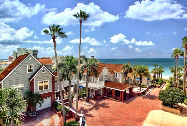
Property Record
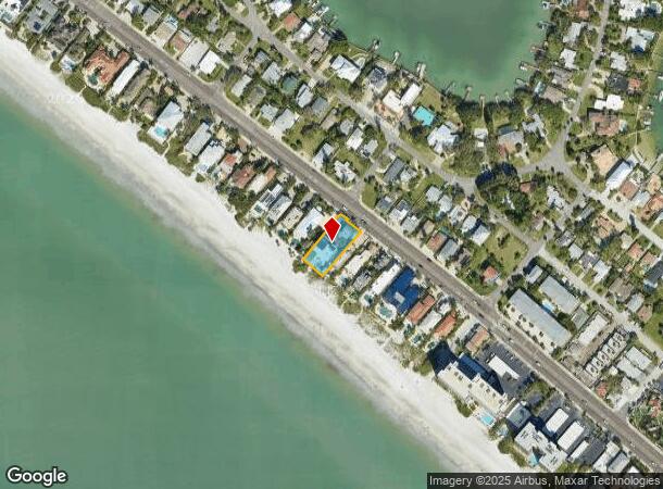
15572 Gulf Blvd, Redington Beach, FL 33708
NEARBY LISTINGS FOR SALE OR LEASE
Property Detail
15572 Gulf Blvd
Tampa-St. Petersburg-Clearwater, FL
Lone Palm Beach
09-31-15-52524-001-0010
LONE PALM BEACH BLK 1, LOTS 1 & 2 & NWLY 7FT OF LOT 3 & SELY 25FT OF LOT 9A, BLK 7 OF LONE PALM BEACH 1ST ADD LESS RD R/W FOR GULF BLVD
Multifamilydwelling
Pinellas
VE
Florida
12103C0191H
3
2024
0.36 AC
2025
Redington Beach
027701
Tampa/St Petersburg
5,753 SF
DEMOGRAPHICS near 15572 Gulf Blvd
1 Mile
3 Mile
5 Mile
2024 Total Population
5,381
40,042
123,962
2029 Population
5,755
41,002
125,695
Pop Growth 2024-2029
+ 6.95%
+ 2.40%
+ 1.40%
Average Age
60
52
50
2024 Total Households
3,023
20,220
58,538
HH Growth 2024-2029
+ 6.81%
+ 2.53%
+ 1.51%
Median Household Inc
$79,861
$70,850
$68,605
Avg Household Size
1.80
1.90
2.10
2024 Avg HH Vehicles
1.00
2.00
2.00
Median Home Value
$487,725
$388,100
$329,986
Median Year Built
1975
1974
1973
Nearby Places
Map Layers
Map Styles
 Street
 Aerial
- Restaurants
- Banks
- Shops
- Fitness
- Groceries
PUBLIC TRANSPORTATION
AIRPORT
St Pete-Clearwater International
DRIVE
WALK
Distance
St Pete-Clearwater International
34 min
15.7 mi
Tampa International
DRIVE
WALK
Distance
Tampa International
44 min
26.4 mi
Freight Ports
Port Manatee
DRIVE
WALK
Distance
Port Manatee
52 min
33.6 mi
Nearby Properties
Address
Land Use
TOTAL SIZE
Lot Size
Zoning
Address
Land Use
TOTAL SIZE
Lot Size
Zoning
2,167,184 SF
297.75 AC
PSP
Address
Land Use
TOTAL SIZE
Lot Size
Zoning
372,952 SF
31.56 AC
Address
Land Use
TOTAL SIZE
Lot Size
Zoning
453,486 SF
15.73 AC
Address
Land Use
TOTAL SIZE
Lot Size
Zoning
328,466 SF
18.81 AC
Address
Land Use
TOTAL SIZE
Lot Size
Zoning
101,642 SF
1.43 AC
Address
Land Use
TOTAL SIZE
Lot Size
Zoning
5,647 SF
187.56 AC
AE
Address
Land Use
TOTAL SIZE
Lot Size
Zoning
29,644 SF
19.13 AC
Address
Land Use
TOTAL SIZE
Lot Size
Zoning
145,619 SF
1.68 AC
Address
Land Use
TOTAL SIZE
Lot Size
Zoning
160,086 SF
1.18 AC
Address
Land Use
TOTAL SIZE
Lot Size
Zoning
204,891 SF
18.20 AC
Address
Land Use
TOTAL SIZE
Lot Size
Zoning
236,240 SF
12.38 AC
RPD15
Address
Land Use
TOTAL SIZE
Lot Size
Zoning
222,888 SF
11.83 AC
RPD15
Address
Land Use
TOTAL SIZE
Lot Size
Zoning
385,858 SF
8.83 AC
Address
Land Use
TOTAL SIZE
Lot Size
Zoning
4,704 SF
3.36 AC
Address
Land Use
TOTAL SIZE
Lot Size
Zoning
176,209 SF
27.52 AC
Address
Land Use
TOTAL SIZE
Lot Size
Zoning
440 SF
3.47 AC
Address
Land Use
TOTAL SIZE
Lot Size
Zoning
151,421 SF
1.86 AC
Address
Land Use
TOTAL SIZE
Lot Size
Zoning
84,008 SF
1.49 AC
Address
Land Use
TOTAL SIZE
Lot Size
Zoning
151,149 SF
8.84 AC
RM15
Address
Land Use
TOTAL SIZE
Lot Size
Zoning
160,616 SF
11.88 AC
Address
Land Use
TOTAL SIZE
Lot Size
Zoning
6,531 SF
357.94 AC
PC
Address
Land Use
TOTAL SIZE
Lot Size
Zoning
147,755 SF
6.86 AC
Address
Land Use
TOTAL SIZE
Lot Size
Zoning
Address
Land Use
TOTAL SIZE
Lot Size
Zoning
15,405 SF
31.79 AC
CR
Address
Land Use
TOTAL SIZE
Lot Size
Zoning
139,181 SF
22.21 AC
R2
Address
Land Use
TOTAL SIZE
Lot Size
Zoning
57,532 SF
6.96 AC
Address
Land Use
TOTAL SIZE
Lot Size
Zoning
62,578 SF
5.45 AC
Address
Land Use
TOTAL SIZE
Lot Size
Zoning
235,268 SF
3.01 AC
Address
Land Use
TOTAL SIZE
Lot Size
Zoning
133,610 SF
12.84 AC
Address
Land Use
TOTAL SIZE
Lot Size
Zoning
68,675 SF
2.07 AC
The World's #1 Commercial Real Estate Marketplace
Connect with us
© 2025 CoStar Group
The information above has been obtained from sources believed reliable. While we do not doubt its accuracy we have not verified it and make no guarantee, warranty or representation about it. It is your responsibility to independently confirm its accuracy and completeness. Any projections, opinions, assumptions, or estimates used are for example only and do not represent the current or future performance of the property. The value of this transaction to you depends on tax and other factors which should be evaluated by your tax, financial, and legal advisors. You and your advisors should conduct a careful, independent investigation of the property to determine to your satisfaction the suitability of the property for your needs.