Property Record
156 Piermont Rd, Cresskill, NJ 07626

Current Lease Availabilities
NEARBY LISTINGS FOR SALE OR LEASE
Property Detail
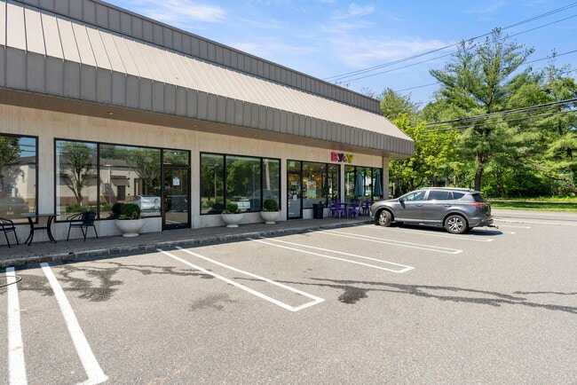
156 Piermont Rd
New York-Jersey City-White Plains, NY-NJ
Clock Tower Square
08-00074-0000-00047-05
102X108
Commercialnec
Bergen
X
New Jersey
34003C0204H
47.5
2024
0.25 AC
2025
Palisades
008001
Northern New Jersey
4,172 SF
DEMOGRAPHICS near 156 Piermont Rd
1 Mile
3 Mile
5 Mile
2024 Total Population
16,420
105,190
416,306
2029 Population
16,451
104,793
410,711
Pop Growth 2024-2029
+ 0.19%
(0.38%)
(1.34%)
Average Age
42
42
41
2024 Total Households
5,481
35,025
149,429
HH Growth 2024-2029
+ 0.16%
(0.45%)
(1.62%)
Median Household Inc
$140,042
$127,385
$98,344
Avg Household Size
2.90
2.90
2.70
2024 Avg HH Vehicles
2.00
2.00
1.00
Median Home Value
$726,744
$569,927
$551,594
Median Year Built
1958
1955
1956
Nearby Places
Map Layers
Map Styles
 Street
 Aerial
- Restaurants
- Banks
- Shops
- Fitness
- Groceries
PUBLIC TRANSPORTATION
AIRPORT
LaGuardia
DRIVE
WALK
Distance
LaGuardia
33 min
19.0 mi
Newark Liberty International
DRIVE
WALK
Distance
Newark Liberty International
29 min
22.7 mi
Westchester County
DRIVE
WALK
Distance
Westchester County
42 min
28.1 mi
Freight Ports
NY - Red Hook Container Terminal
DRIVE
WALK
Distance
NY - Red Hook Container Terminal
43 min
25.0 mi
Nearby Properties
Address
Land Use
TOTAL SIZE
Lot Size
Zoning
Address
Land Use
TOTAL SIZE
Lot Size
Zoning
289.02 AC
P
Address
Land Use
TOTAL SIZE
Lot Size
Zoning
572,137 SF
14.11 AC
R-D
Address
Land Use
TOTAL SIZE
Lot Size
Zoning
185.35 AC
P
Address
Land Use
TOTAL SIZE
Lot Size
Zoning
219.71 AC
O
Address
Land Use
TOTAL SIZE
Lot Size
Zoning
166.61 AC
P
Address
Land Use
TOTAL SIZE
Lot Size
Zoning
4,000 SF
14.69 AC
Address
Land Use
TOTAL SIZE
Lot Size
Zoning
185,878 SF
33.44 AC
B
Address
Land Use
TOTAL SIZE
Lot Size
Zoning
135.51 AC
RR
Address
Land Use
TOTAL SIZE
Lot Size
Zoning
94.42 AC
P
Address
Land Use
TOTAL SIZE
Lot Size
Zoning
9.20 AC
OR
Address
Land Use
TOTAL SIZE
Lot Size
Zoning
225.36 AC
O
Address
Land Use
TOTAL SIZE
Lot Size
Zoning
Address
Land Use
TOTAL SIZE
Lot Size
Zoning
47,623 SF
88.60 AC
B
Address
Land Use
TOTAL SIZE
Lot Size
Zoning
68,824 SF
34.75 AC
R-D
Address
Land Use
TOTAL SIZE
Lot Size
Zoning
7.34 AC
Address
Land Use
TOTAL SIZE
Lot Size
Zoning
163.19 AC
Address
Land Use
TOTAL SIZE
Lot Size
Zoning
173,890 SF
23.80 AC
O
Address
Land Use
TOTAL SIZE
Lot Size
Zoning
36.90 AC
MU
Address
Land Use
TOTAL SIZE
Lot Size
Zoning
Address
Land Use
TOTAL SIZE
Lot Size
Zoning
202,062 SF
29 AC
O
Address
Land Use
TOTAL SIZE
Lot Size
Zoning
146,844 SF
23.68 AC
O
Address
Land Use
TOTAL SIZE
Lot Size
Zoning
58.78 AC
P
Address
Land Use
TOTAL SIZE
Lot Size
Zoning
15.20 AC
A
Address
Land Use
TOTAL SIZE
Lot Size
Zoning
15,828 SF
17.71 AC
Address
Land Use
TOTAL SIZE
Lot Size
Zoning
47.14 AC
P
Address
Land Use
TOTAL SIZE
Lot Size
Zoning
6.93 AC
RMF
Address
Land Use
TOTAL SIZE
Lot Size
Zoning
1,000,000 SF
11.55 AC
RM
Address
Land Use
TOTAL SIZE
Lot Size
Zoning
0.66 AC
RM
Address
Land Use
TOTAL SIZE
Lot Size
Zoning
40.47 AC
DISTRICTN
Address
Land Use
TOTAL SIZE
Lot Size
Zoning
1,314 SF
5.56 AC
A
The World's #1 Commercial Real Estate Marketplace
Connect with us
© 2026 CoStar Group
The information above has been obtained from sources believed reliable. While we do not doubt its accuracy we have not verified it and make no guarantee, warranty or representation about it. It is your responsibility to independently confirm its accuracy and completeness. Any projections, opinions, assumptions, or estimates used are for example only and do not represent the current or future performance of the property. The value of this transaction to you depends on tax and other factors which should be evaluated by your tax, financial, and legal advisors. You and your advisors should conduct a careful, independent investigation of the property to determine to your satisfaction the suitability of the property for your needs.