Property Record
156 Route 66 E, Columbia, CT 06237


Property Detail
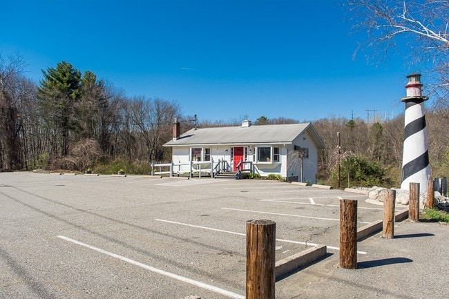
156 Route 66 E
COLU-000007-000000-000011
Capitol
Restaurantbuilding
Connecticut
M
11
2025
2.80 AC
2025
Tolland County
510200
Hartford
1,136 SF
Hartford-West Hartford-East Hartford, CT
NEARBY LISTINGS FOR SALE OR LEASE
DEMOGRAPHICS near 156 Route 66 E
1 mile
3 mile
5 mile
2025 Total Population
596
15,260
40,741
2030 Population
604
15,531
41,485
Pop Growth 2025-2030
+ 1.34%
+ 1.78%
+ 1.83%
Average Age
44
38
40
2025 Total Households
237
5,164
15,516
HH Growth 2025-2030
+ 1.27%
+ 2.07%
+ 1.91%
Median Household Inc
$107,407
$68,471
$69,754
Avg Household Size
2.50
2.40
2.40
2025 Avg HH Vehicles
2.00
2.00
2.00
Median Home Value
$354,487
$288,311
$286,739
Median Year Built
1986
1966
1967
Nearby Places
Map Layers
Map Styles
 Street
 Aerial
Transit
 Traffic
 Biking
Places
Listings with unknown addresses are not visible on the map
- Restaurants
- Banks
- Shops
- Fitness
- Groceries
SALE & LEASE HISTORY
LISTING DATE
SALE/LEASE

Sep 24, 2016
For Sale
Sep 20, 2018
For Sale
Mar 28, 2017
For Sale
Aug 16, 2024
For Sale
Nearby Properties
Address
Land Use
TOTAL SIZE
Lot Size
Zoning
Address
Land Use
TOTAL SIZE
Lot Size
Zoning
14.62 AC
B4
Address
Land Use
TOTAL SIZE
Lot Size
Zoning
33,366 SF
R6
Address
Land Use
TOTAL SIZE
Lot Size
Zoning
111,757 SF
6.74 AC
RL
Address
Land Use
TOTAL SIZE
Lot Size
Zoning
316,812 SF
39.88 AC
R4
Address
Land Use
TOTAL SIZE
Lot Size
Zoning
158,766 SF
3.91 AC
R6
Address
Land Use
TOTAL SIZE
Lot Size
Zoning
63,224 SF
2.68 AC
R6
Address
Land Use
TOTAL SIZE
Lot Size
Zoning
3.50 AC
R6
Address
Land Use
TOTAL SIZE
Lot Size
Zoning
14.12 AC
B2A
Address
Land Use
TOTAL SIZE
Lot Size
Zoning
23.65 AC
RA
Address
Land Use
TOTAL SIZE
Lot Size
Zoning
58,264 SF
5.97 AC
B2A
Address
Land Use
TOTAL SIZE
Lot Size
Zoning
142 AC
R5 - 1
Address
Land Use
TOTAL SIZE
Lot Size
Zoning
40,897 SF
0.62 AC
R6
Address
Land Use
TOTAL SIZE
Lot Size
Zoning
37,665 SF
0.42 AC
B1
Address
Land Use
TOTAL SIZE
Lot Size
Zoning
71,976 SF
3.15 AC
R6
Address
Land Use
TOTAL SIZE
Lot Size
Zoning
53.16 AC
M4
Address
Land Use
TOTAL SIZE
Lot Size
Zoning
22.70 AC
RAR90
Address
Land Use
TOTAL SIZE
Lot Size
Zoning
14.59 AC
R5
Address
Land Use
TOTAL SIZE
Lot Size
Zoning
73,189 SF
2.46 AC
R6
Address
Land Use
TOTAL SIZE
Lot Size
Zoning
48,770 SF
4.06 AC
B2
Address
Land Use
TOTAL SIZE
Lot Size
Zoning
31,818 SF
4.35 AC
B4
Address
Land Use
TOTAL SIZE
Lot Size
Zoning
78 AC
R5
Address
Land Use
TOTAL SIZE
Lot Size
Zoning
107,256 SF
0.31 AC
B1
Address
Land Use
TOTAL SIZE
Lot Size
Zoning
22.10 AC
R6
Address
Land Use
TOTAL SIZE
Lot Size
Zoning
29,548 SF
2.96 AC
RPO
Address
Land Use
TOTAL SIZE
Lot Size
Zoning
2.20 AC
B4
Address
Land Use
TOTAL SIZE
Lot Size
Zoning
61,574 SF
5.10 AC
B2
Address
Land Use
TOTAL SIZE
Lot Size
Zoning
30,379 SF
5.80 AC
C
Address
Land Use
TOTAL SIZE
Lot Size
Zoning
Address
Land Use
TOTAL SIZE
Lot Size
Zoning
14,805 SF
3.60 AC
B4
Address
Land Use
TOTAL SIZE
Lot Size
Zoning
17.53 AC
RL
The World's #1 Commercial Real Estate Marketplace
Connect with us
© 2026 CoStar Group
The information above has been obtained from sources believed reliable. While we do not doubt its accuracy we have not verified it and make no guarantee, warranty or representation about it. It is your responsibility to independently confirm its accuracy and completeness. Any projections, opinions, assumptions, or estimates used are for example only and do not represent the current or future performance of the property. The value of this transaction to you depends on tax and other factors which should be evaluated by your tax, financial, and legal advisors. You and your advisors should conduct a careful, independent investigation of the property to determine to your satisfaction the suitability of the property for your needs.