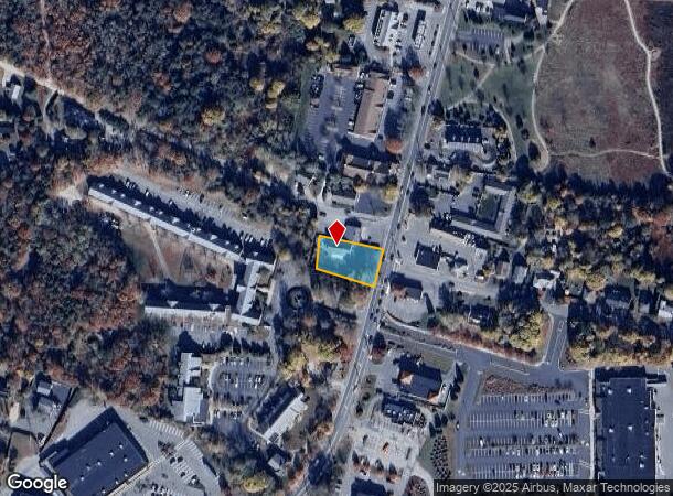
Property Record
156 Teaticket Hwy, Teaticket, MA 02536
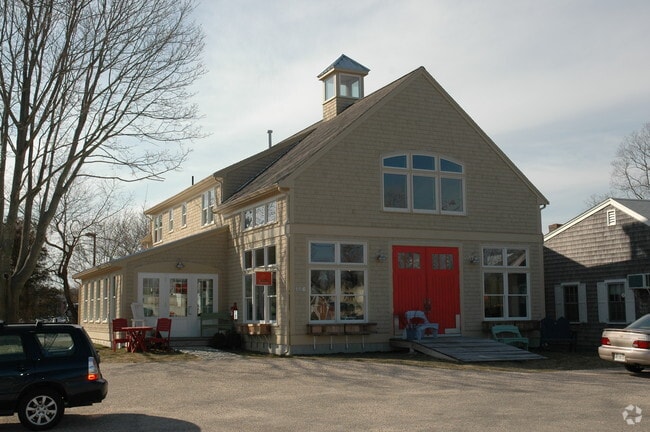

This Property Is For Sale
NEARBY LISTINGS FOR SALE OR LEASE
Property Detail
156 Teaticket Hwy
Barnstable Town, MA
Barnstable
FALM-000039-000023-000011
Massachusetts
Duplex
0.32 AC
X
Cape Cod
25001C0728J
Other Market Areas
5,760 SF
DEMOGRAPHICS near 156 Teaticket Hwy
1 Mile
3 Mile
5 Mile
2024 Total Population
4,292
22,264
33,702
2029 Population
4,498
23,367
35,221
Pop Growth 2024-2029
+ 4.80%
+ 4.95%
+ 4.51%
Average Age
53
51
51
2024 Total Households
2,229
10,607
15,546
HH Growth 2024-2029
+ 4.04%
+ 4.72%
+ 4.37%
Median Household Inc
$75,902
$78,383
$83,831
Avg Household Size
1.90
2.00
2.10
2024 Avg HH Vehicles
2.00
2.00
2.00
Median Home Value
$482,303
$529,158
$539,150
Median Year Built
1973
1972
1975
Nearby Places
Map Layers
Map Styles
 Street
 Aerial
- Restaurants
- Banks
- Shops
- Fitness
- Groceries
Nearby Properties
Address
Land Use
TOTAL SIZE
Lot Size
Zoning
Address
Land Use
TOTAL SIZE
Lot Size
Zoning
276,514 SF
38.06 AC
B2
Address
Land Use
TOTAL SIZE
Lot Size
Zoning
387.44 AC
RA
Address
Land Use
TOTAL SIZE
Lot Size
Zoning
124,999 SF
10 AC
PU
Address
Land Use
TOTAL SIZE
Lot Size
Zoning
102,086 SF
20.95 AC
PU
Address
Land Use
TOTAL SIZE
Lot Size
Zoning
1,343.21 AC
PU
Address
Land Use
TOTAL SIZE
Lot Size
Zoning
81,184 SF
6.61 AC
PU
Address
Land Use
TOTAL SIZE
Lot Size
Zoning
125,628 SF
5.51 AC
AGB
Address
Land Use
TOTAL SIZE
Lot Size
Zoning
61,291 SF
13.43 AC
PU
Address
Land Use
TOTAL SIZE
Lot Size
Zoning
103,987 SF
10 AC
B2
Address
Land Use
TOTAL SIZE
Lot Size
Zoning
41,188 SF
3 AC
PU
Address
Land Use
TOTAL SIZE
Lot Size
Zoning
68,362 SF
4.91 AC
M
Address
Land Use
TOTAL SIZE
Lot Size
Zoning
65,159 SF
33.65 AC
B2
Address
Land Use
TOTAL SIZE
Lot Size
Zoning
59,880 SF
18.39 AC
PU
Address
Land Use
TOTAL SIZE
Lot Size
Zoning
33,157 SF
39.23 AC
PU
Address
Land Use
TOTAL SIZE
Lot Size
Zoning
56,592 SF
16.62 AC
PU
Address
Land Use
TOTAL SIZE
Lot Size
Zoning
166.90 AC
PU
Address
Land Use
TOTAL SIZE
Lot Size
Zoning
88,392 SF
9.20 AC
B2
Address
Land Use
TOTAL SIZE
Lot Size
Zoning
22,380 SF
5.05 AC
PU
Address
Land Use
TOTAL SIZE
Lot Size
Zoning
1,484 SF
88.31 AC
AGA
Address
Land Use
TOTAL SIZE
Lot Size
Zoning
15,546 SF
86.40 AC
PU
Address
Land Use
TOTAL SIZE
Lot Size
Zoning
21,360 SF
3.71 AC
GR
Address
Land Use
TOTAL SIZE
Lot Size
Zoning
100.93 AC
PU
Address
Land Use
TOTAL SIZE
Lot Size
Zoning
19,171 SF
5.43 AC
PU
Address
Land Use
TOTAL SIZE
Lot Size
Zoning
72,138 SF
6.27 AC
PU
Address
Land Use
TOTAL SIZE
Lot Size
Zoning
63,286 SF
5.73 AC
RC
Address
Land Use
TOTAL SIZE
Lot Size
Zoning
7,119 SF
1.55 AC
RB
Address
Land Use
TOTAL SIZE
Lot Size
Zoning
40,560 SF
1.95 AC
M
Address
Land Use
TOTAL SIZE
Lot Size
Zoning
47,394 SF
9.48 AC
PU
Address
Land Use
TOTAL SIZE
Lot Size
Zoning
36,264 SF
19.88 AC
AGAA
Address
Land Use
TOTAL SIZE
Lot Size
Zoning
58,649 SF
3.09 AC
B2
The World's #1 Commercial Real Estate Marketplace
Connect with us
© 2026 CoStar Group
The information above has been obtained from sources believed reliable. While we do not doubt its accuracy we have not verified it and make no guarantee, warranty or representation about it. It is your responsibility to independently confirm its accuracy and completeness. Any projections, opinions, assumptions, or estimates used are for example only and do not represent the current or future performance of the property. The value of this transaction to you depends on tax and other factors which should be evaluated by your tax, financial, and legal advisors. You and your advisors should conduct a careful, independent investigation of the property to determine to your satisfaction the suitability of the property for your needs.