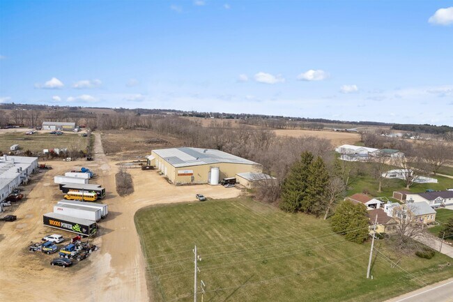
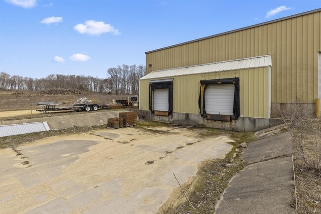
Property Record
1560 Il Route 75 E, Freeport, IL 61032


Property Detail
1560 Il Route 75 E
07-14-28-401-005
PT W1/2 NW1/4 SE1/4 SEC 28-27-8
Commercialnec
STEPHENSON
B and X Area of moderate flood hazard, usually the area between the limits of the 100-year and 500-year floods.
Illinois
2024
9.39 AC
2024
Illinois North Area
000700
Other Market Areas
32,878 SF
Freeport, IL
NEARBY LISTINGS FOR SALE OR LEASE
DEMOGRAPHICS near 1560 Il Route 75 E
1 mile
3 mile
5 mile
2025 Total Population
249
13,528
26,389
2030 Population
243
13,519
25,973
Pop Growth 2025-2030
(2.41%)
(0.07%)
(1.58%)
Average Age
43
40
43
2025 Total Households
109
5,666
11,519
HH Growth 2025-2030
(2.75%)
(0.16%)
(1.75%)
Median Household Inc
$49,166
$47,226
$52,720
Avg Household Size
2.30
2.20
2.20
2025 Avg HH Vehicles
2.00
1.00
2.00
Median Home Value
$97,560
$63,272
$97,820
Median Year Built
1951
1948
1958
Nearby Places
Map Layers
Map Styles
 Street
 Aerial
Layers
 Traffic
 Biking
Places
Listings with unknown addresses are not visible on the map
- Restaurants
- Banks
- Shops
- Fitness
- Groceries
PUBLIC TRANSPORTATION
AIRPORT
Chicago/Rockford International
Drive
Walk
Distance
Chicago/Rockford International
45 min
33.1 mi
Freight Ports
Port Milwaukee
Drive
Walk
Distance
Port Milwaukee
142 min
111.5 mi
SALE & LEASE HISTORY
LISTING DATE
SALE/LEASE

Apr 10, 2024
For Sale
Nearby Properties
Address
Land Use
TOTAL SIZE
Lot Size
Zoning
Address
Land Use
TOTAL SIZE
Lot Size
Zoning
499,200 SF
36.03 AC
Address
Land Use
TOTAL SIZE
Lot Size
Zoning
Address
Land Use
TOTAL SIZE
Lot Size
Zoning
148.08 AC
Address
Land Use
TOTAL SIZE
Lot Size
Zoning
4.13 AC
Address
Land Use
TOTAL SIZE
Lot Size
Zoning
38.59 AC
Address
Land Use
TOTAL SIZE
Lot Size
Zoning
7,754 SF
0.61 AC
Address
Land Use
TOTAL SIZE
Lot Size
Zoning
28.06 AC
Address
Land Use
TOTAL SIZE
Lot Size
Zoning
1.77 AC
Address
Land Use
TOTAL SIZE
Lot Size
Zoning
19.66 AC
Address
Land Use
TOTAL SIZE
Lot Size
Zoning
15.25 AC
Address
Land Use
TOTAL SIZE
Lot Size
Zoning
11,364 SF
1.97 AC
Address
Land Use
TOTAL SIZE
Lot Size
Zoning
9.08 AC
Address
Land Use
TOTAL SIZE
Lot Size
Zoning
2.53 AC
Address
Land Use
TOTAL SIZE
Lot Size
Zoning
Address
Land Use
TOTAL SIZE
Lot Size
Zoning
18,688 SF
2.70 AC
Address
Land Use
TOTAL SIZE
Lot Size
Zoning
27,502 SF
0.83 AC
Address
Land Use
TOTAL SIZE
Lot Size
Zoning
Address
Land Use
TOTAL SIZE
Lot Size
Zoning
Address
Land Use
TOTAL SIZE
Lot Size
Zoning
Address
Land Use
TOTAL SIZE
Lot Size
Zoning
0.38 AC
Address
Land Use
TOTAL SIZE
Lot Size
Zoning
7,000 SF
4.87 AC
Address
Land Use
TOTAL SIZE
Lot Size
Zoning
16.60 AC
Address
Land Use
TOTAL SIZE
Lot Size
Zoning
11,868 SF
0.99 AC
Address
Land Use
TOTAL SIZE
Lot Size
Zoning
19.12 AC
Address
Land Use
TOTAL SIZE
Lot Size
Zoning
1,672 SF
5.03 AC
Address
Land Use
TOTAL SIZE
Lot Size
Zoning
8,000 SF
14.36 AC
Address
Land Use
TOTAL SIZE
Lot Size
Zoning
21,840 SF
8 AC
Address
Land Use
TOTAL SIZE
Lot Size
Zoning
10,269 SF
3.44 AC
Address
Land Use
TOTAL SIZE
Lot Size
Zoning
7,272 SF
1.33 AC
Address
Land Use
TOTAL SIZE
Lot Size
Zoning
0.44 AC
The World's #1 Commercial Real Estate Marketplace
Connect with us
© 2026 CoStar Group
The information above has been obtained from sources believed reliable. While we do not doubt its accuracy we have not verified it and make no guarantee, warranty or representation about it. It is your responsibility to independently confirm its accuracy and completeness. Any projections, opinions, assumptions, or estimates used are for example only and do not represent the current or future performance of the property. The value of this transaction to you depends on tax and other factors which should be evaluated by your tax, financial, and legal advisors. You and your advisors should conduct a careful, independent investigation of the property to determine to your satisfaction the suitability of the property for your needs.