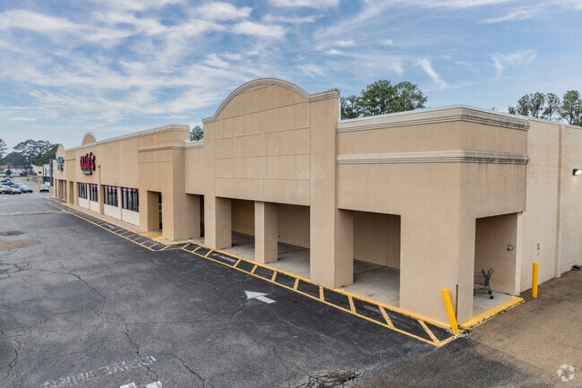
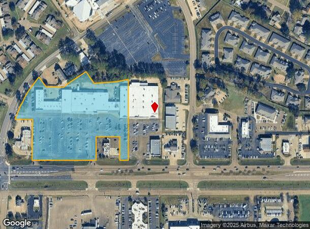
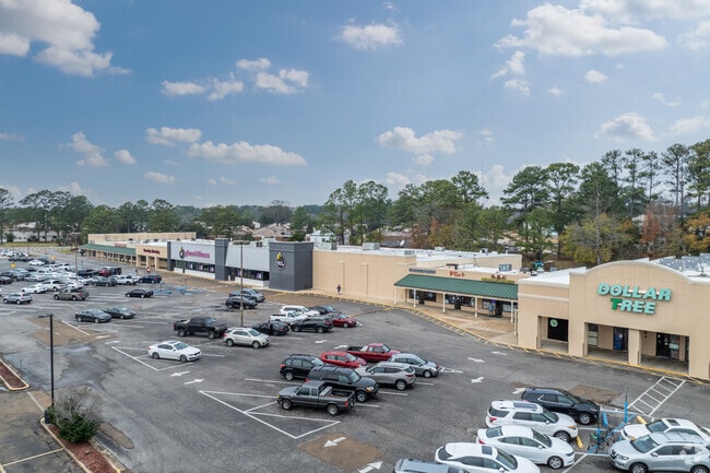
Property Record
1560 W Government St, Brandon, MS 39042

NEARBY LISTINGS FOR SALE OR LEASE
Property Detail
1560 W Government St
H09B-000008-00000
7.74 AC IN SE4 SE4 (EXTENDS INTO SEC 8) DB 407 PG 41 0081580 DB 433 PG 0436 0122281
Stripcommercialcenter
Rankin
X
Mississippi
28121C0192F
7.74 AC
2024
Brandon/Flowood/Pearl
2024
Jackson
020208
Jackson, MS
47,718 SF
DEMOGRAPHICS near 1560 W Government St
1 Mile
3 Mile
5 Mile
2024 Total Population
4,844
26,533
58,330
2029 Population
4,919
27,110
59,787
Pop Growth 2024-2029
+ 1.55%
+ 2.17%
+ 2.50%
Average Age
45
41
40
2024 Total Households
2,093
10,588
22,331
HH Growth 2024-2029
+ 1.62%
+ 2.00%
+ 2.50%
Median Household Inc
$72,684
$75,187
$78,926
Avg Household Size
2.30
2.40
2.50
2024 Avg HH Vehicles
2.00
2.00
2.00
Median Home Value
$202,782
$215,897
$222,542
Median Year Built
1979
1992
1995
Nearby Places
Map Layers
Map Styles
 Street
 Aerial
- Restaurants
- Banks
- Shops
- Fitness
- Groceries
PUBLIC TRANSPORTATION
AIRPORT
Jackson-Medgar Wiley Evers International
DRIVE
WALK
Distance
Jackson-Medgar Wiley Evers International
11 min
5.2 mi
Freight Ports
Port of Gulf Port
DRIVE
WALK
Distance
Port of Gulf Port
201 min
165.2 mi
SALE & LEASE HISTORY
LISTING DATE
SALE/LEASE

Sep 25, 2016
For Lease
Nearby Properties
Address
Land Use
TOTAL SIZE
Lot Size
Zoning
Address
Land Use
TOTAL SIZE
Lot Size
Zoning
57,040 SF
6.83 AC
Address
Land Use
TOTAL SIZE
Lot Size
Zoning
40,697 SF
0.85 AC
Address
Land Use
TOTAL SIZE
Lot Size
Zoning
17,930 SF
6.04 AC
Address
Land Use
TOTAL SIZE
Lot Size
Zoning
179,539 SF
18.61 AC
Address
Land Use
TOTAL SIZE
Lot Size
Zoning
23,401 SF
23.11 AC
Address
Land Use
TOTAL SIZE
Lot Size
Zoning
9.40 AC
Address
Land Use
TOTAL SIZE
Lot Size
Zoning
20,566 SF
5.73 AC
Address
Land Use
TOTAL SIZE
Lot Size
Zoning
354,086 SF
26.82 AC
Address
Land Use
TOTAL SIZE
Lot Size
Zoning
1,866 SF
10 AC
Address
Land Use
TOTAL SIZE
Lot Size
Zoning
59,260 SF
5.10 AC
Address
Land Use
TOTAL SIZE
Lot Size
Zoning
30,800 SF
5.66 AC
Address
Land Use
TOTAL SIZE
Lot Size
Zoning
228,770 SF
24.32 AC
Address
Land Use
TOTAL SIZE
Lot Size
Zoning
8,926 SF
14 AC
Address
Land Use
TOTAL SIZE
Lot Size
Zoning
2,133 SF
8.18 AC
Address
Land Use
TOTAL SIZE
Lot Size
Zoning
10,996 SF
13.89 AC
Address
Land Use
TOTAL SIZE
Lot Size
Zoning
45.54 AC
Address
Land Use
TOTAL SIZE
Lot Size
Zoning
2,596 SF
10.85 AC
Address
Land Use
TOTAL SIZE
Lot Size
Zoning
27.70 AC
Address
Land Use
TOTAL SIZE
Lot Size
Zoning
32,771 SF
17.99 AC
Address
Land Use
TOTAL SIZE
Lot Size
Zoning
87,948 SF
21.19 AC
Address
Land Use
TOTAL SIZE
Lot Size
Zoning
180,718 SF
9.90 AC
Address
Land Use
TOTAL SIZE
Lot Size
Zoning
28,690 SF
2.15 AC
Address
Land Use
TOTAL SIZE
Lot Size
Zoning
16,964 SF
30.85 AC
Address
Land Use
TOTAL SIZE
Lot Size
Zoning
36,230 SF
10.23 AC
Address
Land Use
TOTAL SIZE
Lot Size
Zoning
69.13 AC
Address
Land Use
TOTAL SIZE
Lot Size
Zoning
111,879 SF
12.54 AC
Address
Land Use
TOTAL SIZE
Lot Size
Zoning
7,216 SF
11.75 AC
Address
Land Use
TOTAL SIZE
Lot Size
Zoning
9,839 SF
0.92 AC
Address
Land Use
TOTAL SIZE
Lot Size
Zoning
8,964 SF
16.76 AC
Address
Land Use
TOTAL SIZE
Lot Size
Zoning
12.23 AC
The World's #1 Commercial Real Estate Marketplace
Connect with us
© 2026 CoStar Group
The information above has been obtained from sources believed reliable. While we do not doubt its accuracy we have not verified it and make no guarantee, warranty or representation about it. It is your responsibility to independently confirm its accuracy and completeness. Any projections, opinions, assumptions, or estimates used are for example only and do not represent the current or future performance of the property. The value of this transaction to you depends on tax and other factors which should be evaluated by your tax, financial, and legal advisors. You and your advisors should conduct a careful, independent investigation of the property to determine to your satisfaction the suitability of the property for your needs.