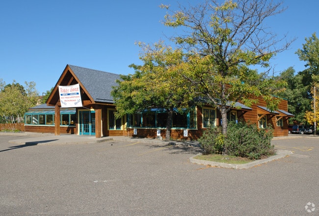
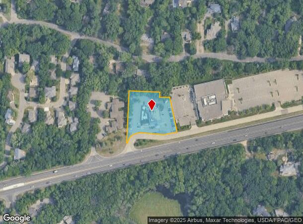
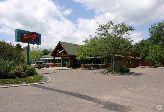
Property Record
15600 Highway 7, Minnetonka, MN 55345

NEARBY LISTINGS FOR SALE OR LEASE
Property Detail
15600 Highway 7
21-117-22-34-0006
Reg. Land Survey No. 1306
Commercialnec
T REG. LAND SURVEY NO. 1306 TRACT B SUBJECT TO HIGHWAY IRREGULAR
X
Hennepin
27053C0336F
Minnesota
2024
1.34 AC
2024
Ridgedale
026202
Minneapolis/St Paul
5,851 SF
Minneapolis-St. Paul-Bloomington, MN-WI
DEMOGRAPHICS near 15600 Highway 7
1 Mile
3 Mile
5 Mile
2024 Total Population
6,388
47,208
145,504
2029 Population
6,224
46,392
144,274
Pop Growth 2024-2029
(2.57%)
(1.73%)
(0.85%)
Average Age
44
43
43
2024 Total Households
2,423
18,841
62,116
HH Growth 2024-2029
(2.72%)
(1.82%)
(0.95%)
Median Household Inc
$131,877
$120,216
$102,977
Avg Household Size
2.60
2.40
2.30
2024 Avg HH Vehicles
2.00
2.00
2.00
Median Home Value
$430,283
$429,840
$423,151
Median Year Built
1966
1974
1980
Nearby Places
Map Layers
Map Styles
 Street
 Aerial
- Restaurants
- Banks
- Shops
- Fitness
- Groceries
PUBLIC TRANSPORTATION
AIRPORT
Minneapolis-St Paul International/Wold-Chamberlain
DRIVE
WALK
Distance
Minneapolis-St Paul International/Wold-Chamberlain
26 min
17.5 mi
Nearby Properties
Address
Land Use
TOTAL SIZE
Lot Size
Zoning
Address
Land Use
TOTAL SIZE
Lot Size
Zoning
171,900 SF
39.17 AC
B1
Address
Land Use
TOTAL SIZE
Lot Size
Zoning
46,726 SF
2.65 AC
PUD
Address
Land Use
TOTAL SIZE
Lot Size
Zoning
11.56 AC
Address
Land Use
TOTAL SIZE
Lot Size
Zoning
20.18 AC
RM65
Address
Land Use
TOTAL SIZE
Lot Size
Zoning
2,676 SF
3.17 AC
PUD
Address
Land Use
TOTAL SIZE
Lot Size
Zoning
7.38 AC
Address
Land Use
TOTAL SIZE
Lot Size
Zoning
7.06 AC
PUD
Address
Land Use
TOTAL SIZE
Lot Size
Zoning
49,925 SF
18.37 AC
B1
Address
Land Use
TOTAL SIZE
Lot Size
Zoning
129,168 SF
16.01 AC
PUD
Address
Land Use
TOTAL SIZE
Lot Size
Zoning
7,209 SF
2.53 AC
B1
Address
Land Use
TOTAL SIZE
Lot Size
Zoning
177,644 SF
10.49 AC
I1
Address
Land Use
TOTAL SIZE
Lot Size
Zoning
55,780 SF
9.93 AC
PUD
Address
Land Use
TOTAL SIZE
Lot Size
Zoning
29,091 SF
34.94 AC
PUD
Address
Land Use
TOTAL SIZE
Lot Size
Zoning
7.82 AC
R4
Address
Land Use
TOTAL SIZE
Lot Size
Zoning
17.67 AC
R4
Address
Land Use
TOTAL SIZE
Lot Size
Zoning
111,335 SF
9.71 AC
B2
Address
Land Use
TOTAL SIZE
Lot Size
Zoning
9.29 AC
R4
Address
Land Use
TOTAL SIZE
Lot Size
Zoning
88,948 SF
10.14 AC
B2
Address
Land Use
TOTAL SIZE
Lot Size
Zoning
14.04 AC
R4
Address
Land Use
TOTAL SIZE
Lot Size
Zoning
28,208 SF
6.15 AC
PUD
Address
Land Use
TOTAL SIZE
Lot Size
Zoning
152,823 SF
12.14 AC
I1
Address
Land Use
TOTAL SIZE
Lot Size
Zoning
122,775 SF
11.75 AC
C-COM
Address
Land Use
TOTAL SIZE
Lot Size
Zoning
0.01 AC
Address
Land Use
TOTAL SIZE
Lot Size
Zoning
38,825 SF
5.38 AC
B3
Address
Land Use
TOTAL SIZE
Lot Size
Zoning
12,248 SF
1.58 AC
B2
Address
Land Use
TOTAL SIZE
Lot Size
Zoning
47,485 SF
2.19 AC
PUD
Address
Land Use
TOTAL SIZE
Lot Size
Zoning
9.04 AC
RM65
Address
Land Use
TOTAL SIZE
Lot Size
Zoning
Address
Land Use
TOTAL SIZE
Lot Size
Zoning
1,000 SF
14 AC
Address
Land Use
TOTAL SIZE
Lot Size
Zoning
8.39 AC
PUD
The World's #1 Commercial Real Estate Marketplace
Connect with us
© 2025 CoStar Group
The information above has been obtained from sources believed reliable. While we do not doubt its accuracy we have not verified it and make no guarantee, warranty or representation about it. It is your responsibility to independently confirm its accuracy and completeness. Any projections, opinions, assumptions, or estimates used are for example only and do not represent the current or future performance of the property. The value of this transaction to you depends on tax and other factors which should be evaluated by your tax, financial, and legal advisors. You and your advisors should conduct a careful, independent investigation of the property to determine to your satisfaction the suitability of the property for your needs.