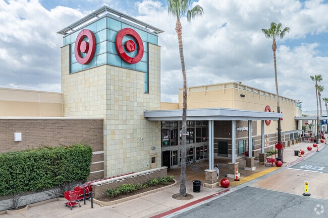
Property Record
15614 Whittwood Ln, Whittier, CA 90603
Current Lease Availabilities
NEARBY LISTINGS FOR SALE OR LEASE
Property Detail
15614 Whittwood Ln
Los Angeles-Long Beach-Glendale, CA
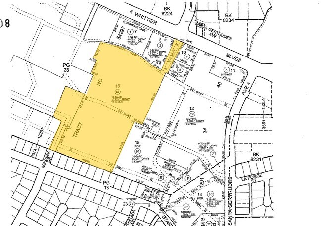
54297
8230-029-015
TR=54297 FOR DESC SEE ASSESSORS MAPS POR OF LOTS 17 AND 19
Regionalshoppingcenterormallwithanchorstore
Los Angeles
X
California
06059C0028J
17,19
2024
11.24 AC
2025
Southeast Los Angeles
503402
Los Angeles
142,430 SF
DEMOGRAPHICS near 15614 Whittwood Ln
1 Mile
3 Mile
5 Mile
2024 Total Population
19,980
170,559
394,411
2029 Population
19,252
165,625
382,551
Pop Growth 2024-2029
(3.64%)
(2.89%)
(3.01%)
Average Age
40
40
40
2024 Total Households
6,323
53,338
122,149
HH Growth 2024-2029
(3.94%)
(3.10%)
(3.23%)
Median Household Inc
$110,568
$95,200
$93,988
Avg Household Size
3.10
3.10
3.10
2024 Avg HH Vehicles
2.00
2.00
2.00
Median Home Value
$755,750
$738,075
$738,560
Median Year Built
1956
1959
1962
Nearby Places
Map Layers
Map Styles
 Street
 Aerial
- Restaurants
- Banks
- Shops
- Fitness
- Groceries
PUBLIC TRANSPORTATION
COMMUTER RAIL
Buena Park (91 Line - Southern California Regional Rail Authority (Metrolink), Orange County Line - Southern California Regional Rail Authority (Metrolink))
DRIVE
WALK
Distance
Buena Park (91 Line - Southern California Regional Rail Authority (Metrolink), Orange County Line - Southern California Regional Rail Authority (Metrolink))
15 min
5.7 mi
Norwalk/Santa Fe Springs (91 Line - Southern California Regional Rail Authority (Metrolink), Orange County Line - Southern California Regional Rail Authority (Metrolink))
DRIVE
WALK
Distance
Norwalk/Santa Fe Springs (91 Line - Southern California Regional Rail Authority (Metrolink), Orange County Line - Southern California Regional Rail Authority (Metrolink))
15 min
6.2 mi
AIRPORT
Long Beach (Daugherty Field)
DRIVE
WALK
Distance
Long Beach (Daugherty Field)
36 min
23.7 mi
John Wayne/Orange County
DRIVE
WALK
Distance
John Wayne/Orange County
36 min
26.9 mi
Ontario International
DRIVE
WALK
Distance
Ontario International
41 min
29.6 mi
Freight Ports
Port of Long Beach
DRIVE
WALK
Distance
Port of Long Beach
1 min
16.3 mi
Nearby Properties
Address
Land Use
TOTAL SIZE
Lot Size
Zoning
Address
Land Use
TOTAL SIZE
Lot Size
Zoning
150,561 SF
65.24 AC
LMPUD
Address
Land Use
TOTAL SIZE
Lot Size
Zoning
10.49 AC
Address
Land Use
TOTAL SIZE
Lot Size
Zoning
128,481 SF
19.42 AC
LMR1*
Address
Land Use
TOTAL SIZE
Lot Size
Zoning
10.49 AC
Address
Land Use
TOTAL SIZE
Lot Size
Zoning
178,140 SF
10.88 AC
Address
Land Use
TOTAL SIZE
Lot Size
Zoning
89,514 SF
21.28 AC
WHC2*
Address
Land Use
TOTAL SIZE
Lot Size
Zoning
15.11 AC
Address
Land Use
TOTAL SIZE
Lot Size
Zoning
85,245 SF
7.44 AC
WHT*
Address
Land Use
TOTAL SIZE
Lot Size
Zoning
60,710 SF
8.77 AC
LCA1*
Address
Land Use
TOTAL SIZE
Lot Size
Zoning
161,861 SF
17.50 AC
SSC4PD*
Address
Land Use
TOTAL SIZE
Lot Size
Zoning
Address
Land Use
TOTAL SIZE
Lot Size
Zoning
31.82 AC
Address
Land Use
TOTAL SIZE
Lot Size
Zoning
96,802 SF
4.93 AC
Address
Land Use
TOTAL SIZE
Lot Size
Zoning
41,430 SF
5.85 AC
Address
Land Use
TOTAL SIZE
Lot Size
Zoning
67,692 SF
2.34 AC
WHC2*
Address
Land Use
TOTAL SIZE
Lot Size
Zoning
14.86 AC
Address
Land Use
TOTAL SIZE
Lot Size
Zoning
13.60 AC
Address
Land Use
TOTAL SIZE
Lot Size
Zoning
192,740 SF
10.18 AC
Address
Land Use
TOTAL SIZE
Lot Size
Zoning
97,952 SF
4.18 AC
WHR3*
Address
Land Use
TOTAL SIZE
Lot Size
Zoning
408,784 SF
9.29 AC
Address
Land Use
TOTAL SIZE
Lot Size
Zoning
61,934 SF
2.37 AC
LCA1YY
Address
Land Use
TOTAL SIZE
Lot Size
Zoning
144,914 SF
1.88 AC
WHC2*
Address
Land Use
TOTAL SIZE
Lot Size
Zoning
242,099 SF
3.64 AC
LMR1*
Address
Land Use
TOTAL SIZE
Lot Size
Zoning
82,769 SF
4.25 AC
LMR3*
Address
Land Use
TOTAL SIZE
Lot Size
Zoning
83,364 SF
2.35 AC
WHR4*
Address
Land Use
TOTAL SIZE
Lot Size
Zoning
37.56 AC
Address
Land Use
TOTAL SIZE
Lot Size
Zoning
54,070 SF
2.51 AC
LCR330U*
Address
Land Use
TOTAL SIZE
Lot Size
Zoning
61,988 SF
1.29 AC
WHC2*
Address
Land Use
TOTAL SIZE
Lot Size
Zoning
59,060 SF
6.05 AC
LMPUD*
The World's #1 Commercial Real Estate Marketplace
Connect with us
© 2025 CoStar Group
The information above has been obtained from sources believed reliable. While we do not doubt its accuracy we have not verified it and make no guarantee, warranty or representation about it. It is your responsibility to independently confirm its accuracy and completeness. Any projections, opinions, assumptions, or estimates used are for example only and do not represent the current or future performance of the property. The value of this transaction to you depends on tax and other factors which should be evaluated by your tax, financial, and legal advisors. You and your advisors should conduct a careful, independent investigation of the property to determine to your satisfaction the suitability of the property for your needs.