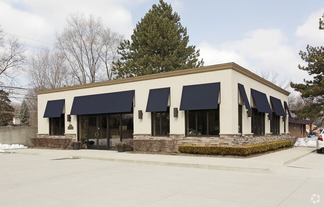
Property Record
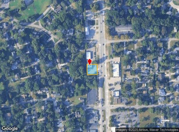
15619 Farmington Rd, Livonia, MI 48154

Current Lease Availabilities
NEARBY LISTINGS FOR SALE OR LEASE
Property Detail
15619 Farmington Rd
Detroit-Warren-Dearborn, MI
Coventry Gardens
46-064-01-0231-000
16A231 TO 235 COVENTRY GARDENS T1SR9E L55 P34 35 WCR LOTS 231 TO 235 INCL ALSO E 1/2 ADJ VAC ALLEY
Officebuilding
Wayne
X
Michigan
26163C0063E
231-235
2024
0.25 AC
2025
Southern I-275 Corridor
557400
Detroit
2,000 SF
DEMOGRAPHICS near 15619 Farmington Rd
1 Mile
3 Mile
5 Mile
2024 Total Population
7,831
64,299
227,856
2029 Population
7,496
61,491
219,428
Pop Growth 2024-2029
(4.28%)
(4.37%)
(3.70%)
Average Age
44
45
43
2024 Total Households
3,096
26,292
97,996
HH Growth 2024-2029
(4.30%)
(4.38%)
(3.69%)
Median Household Inc
$104,717
$95,591
$76,950
Avg Household Size
2.50
2.40
2.30
2024 Avg HH Vehicles
2.00
2.00
2.00
Median Home Value
$275,584
$258,490
$212,277
Median Year Built
1963
1965
1965
Nearby Places
- Restaurants
- Banks
- Shops
- Fitness
- Groceries
PUBLIC TRANSPORTATION
AIRPORT
Detroit Metro Wayne County
DRIVE
WALK
Distance
Detroit Metro Wayne County
28 min
22.9 mi
Windsor International
DRIVE
WALK
Distance
Windsor International
47 min
30.3 mi
Freight Ports
Port of Toledo
DRIVE
WALK
Distance
Port of Toledo
78 min
64.5 mi
Nearby Properties
Address
Land Use
TOTAL SIZE
Lot Size
Zoning
Address
Land Use
TOTAL SIZE
Lot Size
Zoning
3,733,882 SF
183.17 AC
M-2
Address
Land Use
TOTAL SIZE
Lot Size
Zoning
1,316,911 SF
72.87 AC
M-1
Address
Land Use
TOTAL SIZE
Lot Size
Zoning
909,159 SF
55.33 AC
M-2
Address
Land Use
TOTAL SIZE
Lot Size
Zoning
199,485 SF
10.31 AC
R-9
Address
Land Use
TOTAL SIZE
Lot Size
Zoning
730,656 SF
13.73 AC
C-4
Address
Land Use
TOTAL SIZE
Lot Size
Zoning
1,013,885 SF
36.48 AC
M-1
Address
Land Use
TOTAL SIZE
Lot Size
Zoning
Address
Land Use
TOTAL SIZE
Lot Size
Zoning
Address
Land Use
TOTAL SIZE
Lot Size
Zoning
121,420 SF
16.01 AC
C-2
Address
Land Use
TOTAL SIZE
Lot Size
Zoning
544,245 SF
22.30 AC
PO
Address
Land Use
TOTAL SIZE
Lot Size
Zoning
192,755 SF
Address
Land Use
TOTAL SIZE
Lot Size
Zoning
137,490 SF
12.16 AC
C-2
Address
Land Use
TOTAL SIZE
Lot Size
Zoning
16.21 AC
R-7
Address
Land Use
TOTAL SIZE
Lot Size
Zoning
1,529,287 SF
76.96 AC
M-1
Address
Land Use
TOTAL SIZE
Lot Size
Zoning
151,806 SF
15.61 AC
C-2
Address
Land Use
TOTAL SIZE
Lot Size
Zoning
164,964 SF
14.96 AC
R-7
Address
Land Use
TOTAL SIZE
Lot Size
Zoning
126,180 SF
11.62 AC
C-2
Address
Land Use
TOTAL SIZE
Lot Size
Zoning
216,268 SF
23.58 AC
C-2
Address
Land Use
TOTAL SIZE
Lot Size
Zoning
282,088 SF
14.34 AC
M-2
Address
Land Use
TOTAL SIZE
Lot Size
Zoning
225,520 SF
9.93 AC
PO
Address
Land Use
TOTAL SIZE
Lot Size
Zoning
2,025 SF
14.78 AC
R-7
Address
Land Use
TOTAL SIZE
Lot Size
Zoning
100,887 SF
5.34 AC
C-4
Address
Land Use
TOTAL SIZE
Lot Size
Zoning
386,400 SF
18.22 AC
M-2
Address
Land Use
TOTAL SIZE
Lot Size
Zoning
102,089 SF
10.94 AC
C-2
Address
Land Use
TOTAL SIZE
Lot Size
Zoning
192,038 SF
16.26 AC
C-2
Address
Land Use
TOTAL SIZE
Lot Size
Zoning
123,380 SF
8.92 AC
PO
Address
Land Use
TOTAL SIZE
Lot Size
Zoning
151,605 SF
14.66 AC
C-2
Address
Land Use
TOTAL SIZE
Lot Size
Zoning
150,778 SF
1.73 AC
C-2
Address
Land Use
TOTAL SIZE
Lot Size
Zoning
244,838 SF
8.93 AC
M-1
Address
Land Use
TOTAL SIZE
Lot Size
Zoning
182,700 SF
20.45 AC
C-2
The World's #1 Commercial Real Estate Marketplace
Connect with us
© 2025 CoStar Group
The information above has been obtained from sources believed reliable. While we do not doubt its accuracy we have not verified it and make no guarantee, warranty or representation about it. It is your responsibility to independently confirm its accuracy and completeness. Any projections, opinions, assumptions, or estimates used are for example only and do not represent the current or future performance of the property. The value of this transaction to you depends on tax and other factors which should be evaluated by your tax, financial, and legal advisors. You and your advisors should conduct a careful, independent investigation of the property to determine to your satisfaction the suitability of the property for your needs.