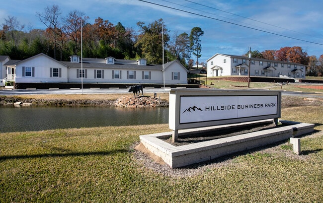
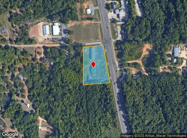
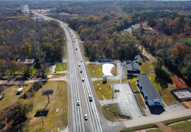
Property Record
15632 State Highway 110 S, Whitehouse, TX 75791
Current Lease Availabilities
NEARBY LISTINGS FOR SALE OR LEASE
Property Detail
15632 State Highway 110 S
1-00000-0858-00-039000
A0858 M Sewell
Commercialofficeresidentialmixeduse
ABST A0858 M SEWELLTRACT 39, 37
AE
Smith
48423C0390D
Texas
2024
2.43 AC
2025
Tyler & Longview
002009
Other Market Areas
4,066 SF
Tyler, TX
DEMOGRAPHICS near 15632 State Highway 110 S
1 Mile
3 Mile
5 Mile
2024 Total Population
324
15,892
56,407
2029 Population
354
17,319
61,517
Pop Growth 2024-2029
+ 9.26%
+ 8.98%
+ 9.06%
Average Age
37
38
39
2024 Total Households
117
5,710
22,555
HH Growth 2024-2029
+ 8.55%
+ 8.41%
+ 8.55%
Median Household Inc
$63,000
$84,346
$74,630
Avg Household Size
2.70
2.70
2.40
2024 Avg HH Vehicles
2.00
2.00
2.00
Median Home Value
$183,333
$216,856
$232,577
Median Year Built
1989
1994
1989
Nearby Places
Map Layers
Map Styles
 Street
 Aerial
- Restaurants
- Banks
- Shops
- Fitness
- Groceries
PUBLIC TRANSPORTATION
AIRPORT
Tyler Pounds Regional
DRIVE
WALK
Distance
Tyler Pounds Regional
27 min
17.1 mi
Freight Ports
Port of Shreveport
DRIVE
WALK
Distance
Port of Shreveport
129 min
113.1 mi
Nearby Properties
Address
Land Use
TOTAL SIZE
Lot Size
Zoning
Address
Land Use
TOTAL SIZE
Lot Size
Zoning
33,409 SF
151.32 AC
M2
Address
Land Use
TOTAL SIZE
Lot Size
Zoning
49,544 SF
28.64 AC
Address
Land Use
TOTAL SIZE
Lot Size
Zoning
84,400 SF
13.98 AC
Address
Land Use
TOTAL SIZE
Lot Size
Zoning
43,165 SF
7.33 AC
Address
Land Use
TOTAL SIZE
Lot Size
Zoning
38,900 SF
20.11 AC
INT
Address
Land Use
TOTAL SIZE
Lot Size
Zoning
75,999 SF
5.09 AC
Address
Land Use
TOTAL SIZE
Lot Size
Zoning
63,737 SF
5.16 AC
Address
Land Use
TOTAL SIZE
Lot Size
Zoning
46.13 AC
Address
Land Use
TOTAL SIZE
Lot Size
Zoning
56,950 SF
4.09 AC
Address
Land Use
TOTAL SIZE
Lot Size
Zoning
67,910 SF
7.36 AC
Address
Land Use
TOTAL SIZE
Lot Size
Zoning
59,534 SF
10 AC
PMF
Address
Land Use
TOTAL SIZE
Lot Size
Zoning
18,000 SF
24.01 AC
Address
Land Use
TOTAL SIZE
Lot Size
Zoning
106,250 SF
19.98 AC
M2
Address
Land Use
TOTAL SIZE
Lot Size
Zoning
16,142 SF
5.40 AC
Address
Land Use
TOTAL SIZE
Lot Size
Zoning
18,808 SF
1.70 AC
Address
Land Use
TOTAL SIZE
Lot Size
Zoning
19.36 AC
Address
Land Use
TOTAL SIZE
Lot Size
Zoning
9,600 SF
5.30 AC
Address
Land Use
TOTAL SIZE
Lot Size
Zoning
82,793 SF
1.94 AC
C2
Address
Land Use
TOTAL SIZE
Lot Size
Zoning
Address
Land Use
TOTAL SIZE
Lot Size
Zoning
18,760 SF
3.34 AC
Address
Land Use
TOTAL SIZE
Lot Size
Zoning
29,395 SF
4.61 AC
Address
Land Use
TOTAL SIZE
Lot Size
Zoning
1,647 SF
14.25 AC
Address
Land Use
TOTAL SIZE
Lot Size
Zoning
2,176 SF
7 AC
Address
Land Use
TOTAL SIZE
Lot Size
Zoning
Address
Land Use
TOTAL SIZE
Lot Size
Zoning
Address
Land Use
TOTAL SIZE
Lot Size
Zoning
9,492 SF
14.25 AC
M1
Address
Land Use
TOTAL SIZE
Lot Size
Zoning
116,370 SF
11.09 AC
M2
Address
Land Use
TOTAL SIZE
Lot Size
Zoning
158.88 AC
Address
Land Use
TOTAL SIZE
Lot Size
Zoning
6,820 SF
2 AC
Address
Land Use
TOTAL SIZE
Lot Size
Zoning
1,560 SF
4.95 AC
The World's #1 Commercial Real Estate Marketplace
Connect with us
© 2026 CoStar Group
The information above has been obtained from sources believed reliable. While we do not doubt its accuracy we have not verified it and make no guarantee, warranty or representation about it. It is your responsibility to independently confirm its accuracy and completeness. Any projections, opinions, assumptions, or estimates used are for example only and do not represent the current or future performance of the property. The value of this transaction to you depends on tax and other factors which should be evaluated by your tax, financial, and legal advisors. You and your advisors should conduct a careful, independent investigation of the property to determine to your satisfaction the suitability of the property for your needs.