Property Record
15634 Highway 5 S, Norfork, AR 72658

Save to a Folder
{{folder.Name}}
{{folder.ListingIds.length}} Properties
{{folder.ListingIds.length}} Property
Create a New Folder
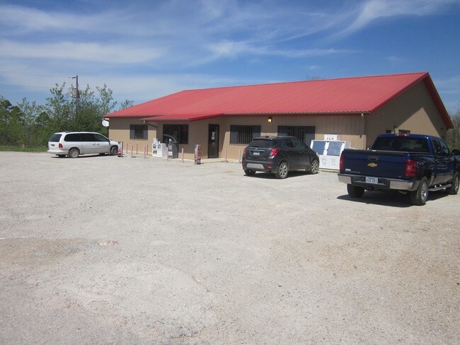
Property Detail
15634 Highway 5 S
008-02945-000
PT NW 1/4 NW 1/4 1.17 ACRES A PART OF THE NORTHWEST (NW1/4) OF THE NORTHWEST (NW1/4) OF SECTION 27, TOWNSHIP 18 NORTH, RANGE 12 WEST, BAXTER COUNTY, ARKANSAS, BOUNDED AND DESCRIBED AS FOLLOWS: BEGINNING AT THE POINT ON THE EAST LINE OF SAID FORTY WHE
Conveniencestore
Baxter
B and X Area of moderate flood hazard, usually the area between the limits of the 100-year and 500-year floods.
Arkansas
2025
1.17 AC
2025
Arkansas North Area
950500
Other Market Areas
5,580 SF
Mountain Home, AR
NEARBY LISTINGS FOR SALE OR LEASE
-
-
View all Norfork listings for sale on LoopNet.com
DEMOGRAPHICS near 15634 Highway 5 S
1 mile
3 mile
5 mile
2025 Total Population
281
1,750
3,188
2030 Population
290
1,826
3,329
Pop Growth 2025-2030
+ 3.20%
+ 4.34%
+ 4.42%
Average Age
46
47
48
2025 Total Households
123
768
1,387
HH Growth 2025-2030
+ 2.44%
+ 4.30%
+ 4.47%
Median Household Inc
$54,687
$52,388
$53,245
Avg Household Size
2.30
2.30
2.30
2025 Avg HH Vehicles
2.00
2.00
2.00
Median Home Value
$184,210
$166,749
$172,625
Median Year Built
1992
1991
1990
Nearby Places
Map Layers
Map Styles
 Street
 Aerial
Layers
 Traffic
 Biking
Places
Listings with unknown addresses are not visible on the map
- Restaurants
- Banks
- Shops
- Fitness
- Groceries
SALE & LEASE HISTORY
LISTING DATE
SALE/LEASE

May 04, 2017
For Sale
Nearby Properties
Address
Land Use
TOTAL SIZE
Lot Size
Zoning
Address
Land Use
TOTAL SIZE
Lot Size
Zoning
2,020 SF
6.90 AC
Address
Land Use
TOTAL SIZE
Lot Size
Zoning
1,586 SF
0.22 AC
Address
Land Use
TOTAL SIZE
Lot Size
Zoning
10,272 SF
2.09 AC
Address
Land Use
TOTAL SIZE
Lot Size
Zoning
4,147 SF
5.75 AC
Address
Land Use
TOTAL SIZE
Lot Size
Zoning
8,370 SF
1.46 AC
Address
Land Use
TOTAL SIZE
Lot Size
Zoning
21,800 SF
2.45 AC
Address
Land Use
TOTAL SIZE
Lot Size
Zoning
4,711 SF
27.74 AC
Address
Land Use
TOTAL SIZE
Lot Size
Zoning
7,560 SF
1.07 AC
Address
Land Use
TOTAL SIZE
Lot Size
Zoning
4,495 SF
0.08 AC
Address
Land Use
TOTAL SIZE
Lot Size
Zoning
1.92 AC
Address
Land Use
TOTAL SIZE
Lot Size
Zoning
1,034 SF
0.04 AC
Address
Land Use
TOTAL SIZE
Lot Size
Zoning
2,688 SF
0.34 AC
Address
Land Use
TOTAL SIZE
Lot Size
Zoning
4.87 AC
Address
Land Use
TOTAL SIZE
Lot Size
Zoning
3,128 SF
0.45 AC
Address
Land Use
TOTAL SIZE
Lot Size
Zoning
3,128 SF
0.34 AC
Address
Land Use
TOTAL SIZE
Lot Size
Zoning
4.25 AC
Address
Land Use
TOTAL SIZE
Lot Size
Zoning
1.81 AC
Address
Land Use
TOTAL SIZE
Lot Size
Zoning
1,586 SF
0.08 AC
Address
Land Use
TOTAL SIZE
Lot Size
Zoning
43.44 AC
Address
Land Use
TOTAL SIZE
Lot Size
Zoning
17.33 AC
Address
Land Use
TOTAL SIZE
Lot Size
Zoning
3.25 AC
Address
Land Use
TOTAL SIZE
Lot Size
Zoning
3.68 AC
Address
Land Use
TOTAL SIZE
Lot Size
Zoning
1,524 SF
2.79 AC
Address
Land Use
TOTAL SIZE
Lot Size
Zoning
5 AC
Address
Land Use
TOTAL SIZE
Lot Size
Zoning
10.27 AC
Address
Land Use
TOTAL SIZE
Lot Size
Zoning
11.77 AC
Address
Land Use
TOTAL SIZE
Lot Size
Zoning
6,112 SF
0.08 AC
Address
Land Use
TOTAL SIZE
Lot Size
Zoning
2.78 AC
Address
Land Use
TOTAL SIZE
Lot Size
Zoning
2.75 AC
The World's #1 Commercial Real Estate Marketplace
Connect with us
© 2026 CoStar Group
The information above has been obtained from sources believed reliable. While we do not doubt its accuracy we have not verified it and make no guarantee, warranty or representation about it. It is your responsibility to independently confirm its accuracy and completeness. Any projections, opinions, assumptions, or estimates used are for example only and do not represent the current or future performance of the property. The value of this transaction to you depends on tax and other factors which should be evaluated by your tax, financial, and legal advisors. You and your advisors should conduct a careful, independent investigation of the property to determine to your satisfaction the suitability of the property for your needs.