Property Record
15634 Wallisville Rd, Houston, TX 77049
NEARBY LISTINGS FOR SALE OR LEASE
Property Detail
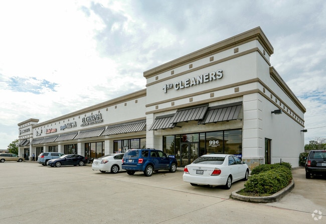
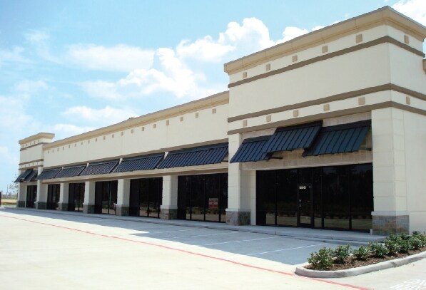
15634 Wallisville Rd
1309110010001
Shops At Wallisville
Storebuilding
RES A BLK 1 SHOPS AT WALLISVILLE
X
Harris
48201C0720M
Texas
2024
0.91 AC
2025
Channelview
252304
Houston
11,700 SF
Houston-The Woodlands-Sugar Land, TX
DEMOGRAPHICS near 15634 Wallisville Rd
1 Mile
3 Mile
5 Mile
2024 Total Population
15,797
104,413
164,369
2029 Population
15,871
106,085
167,488
Pop Growth 2024-2029
+ 0.47%
+ 1.60%
+ 1.90%
Average Age
35
34
34
2024 Total Households
4,839
31,835
49,885
HH Growth 2024-2029
+ 0.37%
+ 1.51%
+ 1.83%
Median Household Inc
$73,932
$57,815
$54,922
Avg Household Size
3.20
3.20
3.20
2024 Avg HH Vehicles
2.00
2.00
2.00
Median Home Value
$191,379
$158,380
$153,810
Median Year Built
2001
1985
1986
Nearby Places
Map Layers
Map Styles
 Street
 Aerial
- Restaurants
- Banks
- Shops
- Fitness
- Groceries
PUBLIC TRANSPORTATION
AIRPORT
William P Hobby
DRIVE
WALK
Distance
William P Hobby
34 min
19.0 mi
George Bush Intcntl/Houston
DRIVE
WALK
Distance
George Bush Intcntl/Houston
24 min
20.3 mi
Freight Ports
Port of Houston
DRIVE
WALK
Distance
Port of Houston
21 min
11.0 mi
SALE & LEASE HISTORY
LISTING DATE
SALE/LEASE

Sep 25, 2016
For Lease
May 26, 2017
For Lease
Feb 16, 2022
For Lease
Nearby Properties
Address
Land Use
TOTAL SIZE
Lot Size
Zoning
Address
Land Use
TOTAL SIZE
Lot Size
Zoning
Address
Land Use
TOTAL SIZE
Lot Size
Zoning
409.44 AC
Address
Land Use
TOTAL SIZE
Lot Size
Zoning
1,056.36 AC
Address
Land Use
TOTAL SIZE
Lot Size
Zoning
183.58 AC
Address
Land Use
TOTAL SIZE
Lot Size
Zoning
36.04 AC
Address
Land Use
TOTAL SIZE
Lot Size
Zoning
1,403,952 SF
48.81 AC
Address
Land Use
TOTAL SIZE
Lot Size
Zoning
337,331 SF
56.09 AC
Address
Land Use
TOTAL SIZE
Lot Size
Zoning
699,448 SF
46.40 AC
Address
Land Use
TOTAL SIZE
Lot Size
Zoning
760,851 SF
41.87 AC
Address
Land Use
TOTAL SIZE
Lot Size
Zoning
671,363 SF
61.27 AC
Address
Land Use
TOTAL SIZE
Lot Size
Zoning
331,284 SF
15.15 AC
Address
Land Use
TOTAL SIZE
Lot Size
Zoning
277,486 SF
15.42 AC
Address
Land Use
TOTAL SIZE
Lot Size
Zoning
398,995 SF
27.39 AC
Address
Land Use
TOTAL SIZE
Lot Size
Zoning
271,428 SF
10.57 AC
Address
Land Use
TOTAL SIZE
Lot Size
Zoning
225,124 SF
10.20 AC
Address
Land Use
TOTAL SIZE
Lot Size
Zoning
202,544 SF
4.06 AC
Address
Land Use
TOTAL SIZE
Lot Size
Zoning
485,662 SF
48.80 AC
Address
Land Use
TOTAL SIZE
Lot Size
Zoning
248,293 SF
13.20 AC
Address
Land Use
TOTAL SIZE
Lot Size
Zoning
526,975 SF
21.08 AC
Address
Land Use
TOTAL SIZE
Lot Size
Zoning
168,348 SF
108.41 AC
Address
Land Use
TOTAL SIZE
Lot Size
Zoning
227,679 SF
13.31 AC
Address
Land Use
TOTAL SIZE
Lot Size
Zoning
110,900 SF
18.01 AC
Address
Land Use
TOTAL SIZE
Lot Size
Zoning
330,927 SF
82.08 AC
Address
Land Use
TOTAL SIZE
Lot Size
Zoning
208,648 SF
8.99 AC
Address
Land Use
TOTAL SIZE
Lot Size
Zoning
392.95 AC
Address
Land Use
TOTAL SIZE
Lot Size
Zoning
537,768 SF
12.46 AC
Address
Land Use
TOTAL SIZE
Lot Size
Zoning
377,109 SF
17.36 AC
Address
Land Use
TOTAL SIZE
Lot Size
Zoning
197,953 SF
8.29 AC
Address
Land Use
TOTAL SIZE
Lot Size
Zoning
48.81 AC
Address
Land Use
TOTAL SIZE
Lot Size
Zoning
246,277 SF
10.91 AC
The World's #1 Commercial Real Estate Marketplace
Connect with us
© 2025 CoStar Group
The information above has been obtained from sources believed reliable. While we do not doubt its accuracy we have not verified it and make no guarantee, warranty or representation about it. It is your responsibility to independently confirm its accuracy and completeness. Any projections, opinions, assumptions, or estimates used are for example only and do not represent the current or future performance of the property. The value of this transaction to you depends on tax and other factors which should be evaluated by your tax, financial, and legal advisors. You and your advisors should conduct a careful, independent investigation of the property to determine to your satisfaction the suitability of the property for your needs.