Property Record
1565 Chenault St, Dallas, TX 75228


Property Detail
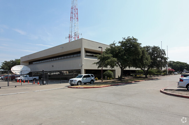
1565 Chenault St
00737400000030000
BLK 7374 PT LOT 3 ACS 8.8982 INT201300343538 DD11012013 CO-DC 7374 000 00300 7DA7374 000
Officebuilding
DALLAS
Z125
Texas
B and X Area of moderate flood hazard, usually the area between the limits of the 100-year and 500-year floods.
3
2024
8.90 AC
2025
White Rock
012211
Dallas/Ft Worth
116,525 SF
Dallas-Fort Worth-Arlington, TX
NEARBY LISTINGS FOR SALE OR LEASE
DEMOGRAPHICS near 1565 Chenault St
1 mile
3 mile
5 mile
2025 Total Population
17,558
124,105
359,845
2030 Population
18,134
127,495
368,779
Pop Growth 2025-2030
+ 3.28%
+ 2.73%
+ 2.48%
Average Age
36
37
37
2025 Total Households
6,931
44,415
130,055
HH Growth 2025-2030
+ 3.35%
+ 2.84%
+ 2.63%
Median Household Inc
$60,028
$67,453
$68,836
Avg Household Size
2.50
2.70
2.70
2025 Avg HH Vehicles
2.00
2.00
2.00
Median Home Value
$353,128
$301,402
$300,786
Median Year Built
1975
1968
1971
Nearby Places
Map Layers
Map Styles
 Street
 Aerial
Layers
 Traffic
 Biking
Places
Listings with unknown addresses are not visible on the map
- Restaurants
- Banks
- Shops
- Fitness
- Groceries
PUBLIC TRANSPORTATION
COMMUTER RAIL
Drive
Walk
Distance
15 min
8.7 mi
AIRPORT
Dallas Love Field
Drive
Walk
Distance
Dallas Love Field
24 min
13.0 mi
Dallas-Fort Worth International
Drive
Walk
Distance
Dallas-Fort Worth International
39 min
28.1 mi
Nearby Properties
Address
Land Use
TOTAL SIZE
Lot Size
Zoning
Address
Land Use
TOTAL SIZE
Lot Size
Zoning
372,564 SF
13.34 AC
Z164
Address
Land Use
TOTAL SIZE
Lot Size
Zoning
634,210 SF
73.19 AC
Z298
Address
Land Use
TOTAL SIZE
Lot Size
Zoning
32,530 SF
0.02 AC
Z239
Address
Land Use
TOTAL SIZE
Lot Size
Zoning
392,842 SF
16.79 AC
Z164
Address
Land Use
TOTAL SIZE
Lot Size
Zoning
184,728 SF
21.62 AC
Z298
Address
Land Use
TOTAL SIZE
Lot Size
Zoning
544,700 SF
29.75 AC
Z125
Address
Land Use
TOTAL SIZE
Lot Size
Zoning
368,350 SF
1.21 AC
Z59
Address
Land Use
TOTAL SIZE
Lot Size
Zoning
252,473 SF
7.28 AC
Z165
Address
Land Use
TOTAL SIZE
Lot Size
Zoning
386,240 SF
20.03 AC
Z237
Address
Land Use
TOTAL SIZE
Lot Size
Zoning
245,023 SF
6.84 AC
Z164
Address
Land Use
TOTAL SIZE
Lot Size
Zoning
588,625 SF
29.01 AC
Z109
Address
Land Use
TOTAL SIZE
Lot Size
Zoning
247,421 SF
3.96 AC
Z133
Address
Land Use
TOTAL SIZE
Lot Size
Zoning
284,990 SF
24.80 AC
Z298
Address
Land Use
TOTAL SIZE
Lot Size
Zoning
555,510 SF
32.62 AC
Z31
Address
Land Use
TOTAL SIZE
Lot Size
Zoning
97,000 SF
12.57 AC
Z239
Address
Land Use
TOTAL SIZE
Lot Size
Zoning
509,014 SF
30.82 AC
Z31
Address
Land Use
TOTAL SIZE
Lot Size
Zoning
530,100 SF
28.84 AC
Z109
Address
Land Use
TOTAL SIZE
Lot Size
Zoning
349,156 SF
10.86 AC
Z59
Address
Land Use
TOTAL SIZE
Lot Size
Zoning
508,750 SF
32.15 AC
Z125
Address
Land Use
TOTAL SIZE
Lot Size
Zoning
457,076 SF
27.74 AC
Z109
Address
Land Use
TOTAL SIZE
Lot Size
Zoning
244,575 SF
9.91 AC
Z164
Address
Land Use
TOTAL SIZE
Lot Size
Zoning
441,696 SF
30.72 AC
Z31
Address
Land Use
TOTAL SIZE
Lot Size
Zoning
397,800 SF
25.51 AC
Z125
Address
Land Use
TOTAL SIZE
Lot Size
Zoning
174,353 SF
12.64 AC
Z248
Address
Land Use
TOTAL SIZE
Lot Size
Zoning
116,162 SF
228.26 AC
Z372
Address
Land Use
TOTAL SIZE
Lot Size
Zoning
171,348 SF
5.70 AC
Z164
Address
Land Use
TOTAL SIZE
Lot Size
Zoning
289,172 SF
12.56 AC
Z164
Address
Land Use
TOTAL SIZE
Lot Size
Zoning
228,857 SF
21.91 AC
Z298
Address
Land Use
TOTAL SIZE
Lot Size
Zoning
110,708 SF
16.79 AC
Z298
Address
Land Use
TOTAL SIZE
Lot Size
Zoning
389,005 SF
25.25 AC
Z109
The World's #1 Commercial Real Estate Marketplace
Connect with us
© 2026 CoStar Group
The information above has been obtained from sources believed reliable. While we do not doubt its accuracy we have not verified it and make no guarantee, warranty or representation about it. It is your responsibility to independently confirm its accuracy and completeness. Any projections, opinions, assumptions, or estimates used are for example only and do not represent the current or future performance of the property. The value of this transaction to you depends on tax and other factors which should be evaluated by your tax, financial, and legal advisors. You and your advisors should conduct a careful, independent investigation of the property to determine to your satisfaction the suitability of the property for your needs.