Property Record
1565 Cipolla Rd, Fruita, CO 81521

NEARBY LISTINGS FOR SALE OR LEASE
-
-
View all Fruita listings for sale on LoopNet.com
Property Detail
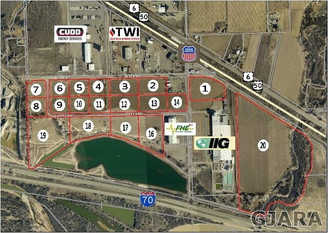
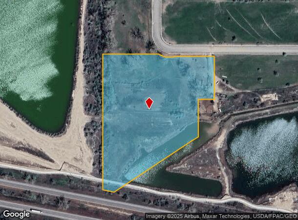
1565 Cipolla Rd
Grand Junction, CO
Pabco Ind Park #2
2693-131-02-019
LOT 19 PABCO INDUSTRIAL PARK FIL NO 2 SEC 12 & 13 1N 3W - 10.36AC
Agriculturalland
Mesa
AE
Colorado
08077C0420F
19
2023
10.36 AC
2024
Colorado Northwest Area
001502
Other Market Areas
DEMOGRAPHICS near 1565 Cipolla Rd
1 Mile
3 Mile
5 Mile
2024 Total Population
318
14,793
18,118
2029 Population
326
15,576
18,985
Pop Growth 2024-2029
+ 2.52%
+ 5.29%
+ 4.79%
Average Age
43
41
41
2024 Total Households
120
5,771
6,989
HH Growth 2024-2029
+ 3.33%
+ 5.29%
+ 4.82%
Median Household Inc
$92,968
$66,694
$70,582
Avg Household Size
2.60
2.60
2.60
2024 Avg HH Vehicles
3.00
2.00
2.00
Median Home Value
$399,999
$354,513
$376,365
Median Year Built
2002
1999
1999
Nearby Places
Map Layers
Map Styles
 Street
 Aerial
- Restaurants
- Banks
- Shops
- Fitness
- Groceries
PUBLIC TRANSPORTATION
AIRPORT
Grand Junction Regional
DRIVE
WALK
Distance
Grand Junction Regional
22 min
15.4 mi
SALE & LEASE HISTORY
LISTING DATE
SALE/LEASE

Sep 24, 2016
For Sale
Feb 19, 2024
For Sale
Aug 07, 2017
For Sale
Nearby Properties
Address
Land Use
TOTAL SIZE
Lot Size
Zoning
Address
Land Use
TOTAL SIZE
Lot Size
Zoning
74,301 SF
0.02 AC
Address
Land Use
TOTAL SIZE
Lot Size
Zoning
188,386 SF
39.06 AC
CSR
Address
Land Use
TOTAL SIZE
Lot Size
Zoning
70,671 SF
12.63 AC
Address
Land Use
TOTAL SIZE
Lot Size
Zoning
57,933 SF
10 AC
CSR
Address
Land Use
TOTAL SIZE
Lot Size
Zoning
58,696 SF
8.37 AC
Address
Land Use
TOTAL SIZE
Lot Size
Zoning
46,918 SF
1.08 AC
Address
Land Use
TOTAL SIZE
Lot Size
Zoning
70,981 SF
0.27 AC
Address
Land Use
TOTAL SIZE
Lot Size
Zoning
64,189 SF
5.47 AC
I-2
Address
Land Use
TOTAL SIZE
Lot Size
Zoning
50,790 SF
9,964.10 AC
TC
Address
Land Use
TOTAL SIZE
Lot Size
Zoning
40,562 SF
22.42 AC
LIRD
Address
Land Use
TOTAL SIZE
Lot Size
Zoning
62,420 SF
4.76 AC
LIRD
Address
Land Use
TOTAL SIZE
Lot Size
Zoning
226,543 SF
28.36 AC
Address
Land Use
TOTAL SIZE
Lot Size
Zoning
16,677 SF
6.75 AC
Address
Land Use
TOTAL SIZE
Lot Size
Zoning
22,712 SF
3.65 AC
CRS
Address
Land Use
TOTAL SIZE
Lot Size
Zoning
16,257 SF
0.66 AC
Address
Land Use
TOTAL SIZE
Lot Size
Zoning
39,496 SF
2.39 AC
Address
Land Use
TOTAL SIZE
Lot Size
Zoning
50,613 SF
5.07 AC
Address
Land Use
TOTAL SIZE
Lot Size
Zoning
31,236 SF
1.20 AC
TCDD
Address
Land Use
TOTAL SIZE
Lot Size
Zoning
23,065 SF
85.08 AC
Address
Land Use
TOTAL SIZE
Lot Size
Zoning
24,495 SF
2.03 AC
Address
Land Use
TOTAL SIZE
Lot Size
Zoning
21,846 SF
4.68 AC
TCDD
Address
Land Use
TOTAL SIZE
Lot Size
Zoning
21,368 SF
35.53 AC
LIRD
Address
Land Use
TOTAL SIZE
Lot Size
Zoning
8.53 AC
Address
Land Use
TOTAL SIZE
Lot Size
Zoning
8.53 AC
Address
Land Use
TOTAL SIZE
Lot Size
Zoning
19,370 SF
4.30 AC
Address
Land Use
TOTAL SIZE
Lot Size
Zoning
14,406 SF
1.77 AC
DCRD
Address
Land Use
TOTAL SIZE
Lot Size
Zoning
26,732 SF
4.75 AC
Address
Land Use
TOTAL SIZE
Lot Size
Zoning
24,605 SF
1.45 AC
Address
Land Use
TOTAL SIZE
Lot Size
Zoning
20,888 SF
4.68 AC
Address
Land Use
TOTAL SIZE
Lot Size
Zoning
6,000 SF
1.27 AC
TCDD
The World's #1 Commercial Real Estate Marketplace
Connect with us
© 2026 CoStar Group
The information above has been obtained from sources believed reliable. While we do not doubt its accuracy we have not verified it and make no guarantee, warranty or representation about it. It is your responsibility to independently confirm its accuracy and completeness. Any projections, opinions, assumptions, or estimates used are for example only and do not represent the current or future performance of the property. The value of this transaction to you depends on tax and other factors which should be evaluated by your tax, financial, and legal advisors. You and your advisors should conduct a careful, independent investigation of the property to determine to your satisfaction the suitability of the property for your needs.