Property Record
1565 Highway 66, Garland, TX 75040
NEARBY LISTINGS FOR SALE OR LEASE
Property Detail
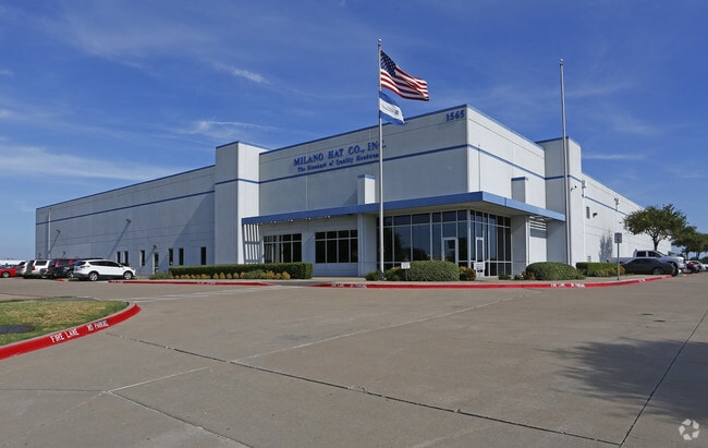
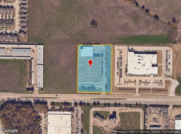
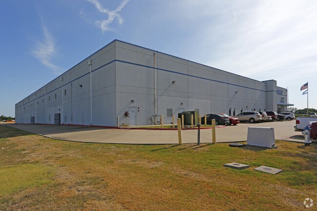
1565 Highway 66
Dallas-Fort Worth-Arlington, TX
Milano Hat
26346760010010000
MILANO HAT BLK 1 LT 1 ACS 4.605 VOL2005003/11232 DD01042005 CO-DC 3467600100100 3CG34676001
Warehouse
Dallas
X
Texas
48113C0240K
1
2024
4.61 AC
2025
NE Dallas/Garland
018121
Dallas/Ft Worth
77,335 SF
DEMOGRAPHICS near 1565 Highway 66
1 Mile
3 Mile
5 Mile
2024 Total Population
12,368
103,990
268,909
2029 Population
12,169
102,730
266,137
Pop Growth 2024-2029
(1.61%)
(1.21%)
(1.03%)
Average Age
36
38
37
2024 Total Households
3,596
33,044
88,849
HH Growth 2024-2029
(1.81%)
(1.43%)
(1.22%)
Median Household Inc
$64,741
$70,302
$70,111
Avg Household Size
3.30
3.10
2.90
2024 Avg HH Vehicles
2.00
2.00
2.00
Median Home Value
$204,374
$225,677
$238,707
Median Year Built
1977
1978
1981
Nearby Places
Map Layers
Map Styles
 Street
 Aerial
- Restaurants
- Banks
- Shops
- Fitness
- Groceries
PUBLIC TRANSPORTATION
AIRPORT
Dallas Love Field
DRIVE
WALK
Distance
Dallas Love Field
35 min
22.5 mi
Dallas-Fort Worth International
DRIVE
WALK
Distance
Dallas-Fort Worth International
43 min
31.3 mi
Freight Ports
Port of Shreveport
DRIVE
WALK
Distance
Port of Shreveport
214 min
194.0 mi
Nearby Properties
Address
Land Use
TOTAL SIZE
Lot Size
Zoning
Address
Land Use
TOTAL SIZE
Lot Size
Zoning
650,164 SF
66.57 AC
Z02
Address
Land Use
TOTAL SIZE
Lot Size
Zoning
310,382 SF
11.78 AC
Z148
Address
Land Use
TOTAL SIZE
Lot Size
Zoning
181,854 SF
14.51 AC
Z239
Address
Land Use
TOTAL SIZE
Lot Size
Zoning
261,164 SF
32.58 AC
Address
Land Use
TOTAL SIZE
Lot Size
Zoning
342,658 SF
4.94 AC
Z239
Address
Land Use
TOTAL SIZE
Lot Size
Zoning
228,458 SF
5.56 AC
Z236
Address
Land Use
TOTAL SIZE
Lot Size
Zoning
331,684 SF
9.80 AC
Z148
Address
Land Use
TOTAL SIZE
Lot Size
Zoning
427,231 SF
9.96 AC
Z38
Address
Land Use
TOTAL SIZE
Lot Size
Zoning
313,217 SF
3.61 AC
Z205
Address
Land Use
TOTAL SIZE
Lot Size
Zoning
65,595 SF
19.22 AC
Z239
Address
Land Use
TOTAL SIZE
Lot Size
Zoning
187,440 SF
1.68 AC
Z25
Address
Land Use
TOTAL SIZE
Lot Size
Zoning
77,102 SF
27.47 AC
Z144
Address
Land Use
TOTAL SIZE
Lot Size
Zoning
198,488 SF
10.17 AC
Z239
Address
Land Use
TOTAL SIZE
Lot Size
Zoning
60,593 SF
35.93 AC
Z06
Address
Land Use
TOTAL SIZE
Lot Size
Zoning
473,201 SF
13.32 AC
Address
Land Use
TOTAL SIZE
Lot Size
Zoning
0.12 AC
Z63
Address
Land Use
TOTAL SIZE
Lot Size
Zoning
168,537 SF
2 AC
Address
Land Use
TOTAL SIZE
Lot Size
Zoning
138,865 SF
11.38 AC
Z239
Address
Land Use
TOTAL SIZE
Lot Size
Zoning
139,133 SF
3.34 AC
Z239
Address
Land Use
TOTAL SIZE
Lot Size
Zoning
133,249 SF
9.71 AC
Z239
Address
Land Use
TOTAL SIZE
Lot Size
Zoning
59,546 SF
60.69 AC
Z390
Address
Land Use
TOTAL SIZE
Lot Size
Zoning
65,917 SF
7.99 AC
Z239
Address
Land Use
TOTAL SIZE
Lot Size
Zoning
145,203 SF
12.86 AC
Z239
Address
Land Use
TOTAL SIZE
Lot Size
Zoning
156,000 SF
2 AC
Address
Land Use
TOTAL SIZE
Lot Size
Zoning
119,397 SF
7.41 AC
Z160
Address
Land Use
TOTAL SIZE
Lot Size
Zoning
76,812 SF
9.22 AC
Z144
Address
Land Use
TOTAL SIZE
Lot Size
Zoning
226,800 SF
4.98 AC
Z340
Address
Land Use
TOTAL SIZE
Lot Size
Zoning
201,347 SF
14.63 AC
Z109
Address
Land Use
TOTAL SIZE
Lot Size
Zoning
78,017 SF
1.75 AC
Z236
Address
Land Use
TOTAL SIZE
Lot Size
Zoning
138,541 SF
3.33 AC
Z25
The World's #1 Commercial Real Estate Marketplace
Connect with us
© 2025 CoStar Group
The information above has been obtained from sources believed reliable. While we do not doubt its accuracy we have not verified it and make no guarantee, warranty or representation about it. It is your responsibility to independently confirm its accuracy and completeness. Any projections, opinions, assumptions, or estimates used are for example only and do not represent the current or future performance of the property. The value of this transaction to you depends on tax and other factors which should be evaluated by your tax, financial, and legal advisors. You and your advisors should conduct a careful, independent investigation of the property to determine to your satisfaction the suitability of the property for your needs.