Property Record
1565 N Hardin Blvd, Mckinney, TX 75071

Property Detail
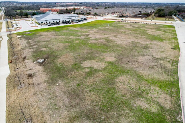
1565 N Hardin Blvd
Dallas-Fort Worth-Arlington, TX
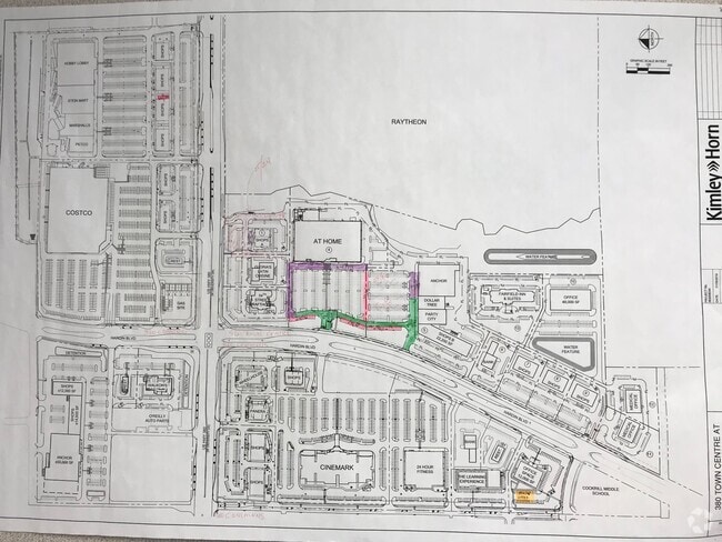
380 COMMONS AT HEADINGTON HEIGHTS ADDITION, BLK A, LOT 8R; ( REPLAT )
R-11896-00A-008R-1
COLLIN
Commercialacreage
Texas
COMM
8r
B and X Area of moderate flood hazard, usually the area between the limits of the 100-year and 500-year floods.
3.51 AC
2025
McKinney
2025
Dallas/Ft Worth
030609
NEARBY LISTINGS FOR SALE OR LEASE
DEMOGRAPHICS near 1565 N Hardin Blvd
1 mile
3 mile
5 mile
2025 Total Population
8,230
92,235
205,456
2030 Population
9,567
105,937
235,396
Pop Growth 2025-2030
+ 16.25%
+ 14.86%
+ 14.57%
Average Age
37
39
38
2025 Total Households
2,687
32,308
71,740
HH Growth 2025-2030
+ 16.41%
+ 14.98%
+ 14.85%
Median Household Inc
$110,554
$129,157
$122,373
Avg Household Size
3.00
2.80
2.80
2025 Avg HH Vehicles
2.00
2.00
2.00
Median Home Value
$434,267
$532,581
$523,015
Median Year Built
2009
2004
2006
Nearby Places
Map Layers
Map Styles
 Street
 Aerial
Transit
 Traffic
 Biking
Places
Listings with unknown addresses are not visible on the map
- Restaurants
- Banks
- Shops
- Fitness
- Groceries
PUBLIC TRANSPORTATION
AIRPORT
Dallas Love Field
Drive
Walk
Distance
Dallas Love Field
45 min
36.2 mi
Freight Ports
Port of Shreveport
Drive
Walk
Distance
Port of Shreveport
241 min
222.4 mi
Nearby Properties
Address
Land Use
TOTAL SIZE
Lot Size
Zoning
Address
Land Use
TOTAL SIZE
Lot Size
Zoning
1,826,199 SF
117.79 AC
Address
Land Use
TOTAL SIZE
Lot Size
Zoning
469,170 SF
56.84 AC
Address
Land Use
TOTAL SIZE
Lot Size
Zoning
1,532,548 SF
270.56 AC
Address
Land Use
TOTAL SIZE
Lot Size
Zoning
755,827 SF
52.76 AC
O
Address
Land Use
TOTAL SIZE
Lot Size
Zoning
691,265 SF
53.52 AC
Address
Land Use
TOTAL SIZE
Lot Size
Zoning
582,987 SF
63.07 AC
Address
Land Use
TOTAL SIZE
Lot Size
Zoning
518,353 SF
28.51 AC
MF-M
Address
Land Use
TOTAL SIZE
Lot Size
Zoning
475,847 SF
16.34 AC
RG-18
Address
Land Use
TOTAL SIZE
Lot Size
Zoning
398,732 SF
25.88 AC
MF-M
Address
Land Use
TOTAL SIZE
Lot Size
Zoning
291,577 SF
69.24 AC
APTTOWNH
Address
Land Use
TOTAL SIZE
Lot Size
Zoning
274,184 SF
20.34 AC
COMM
Address
Land Use
TOTAL SIZE
Lot Size
Zoning
412,593 SF
17.24 AC
Address
Land Use
TOTAL SIZE
Lot Size
Zoning
725,223 SF
46.60 AC
Address
Land Use
TOTAL SIZE
Lot Size
Zoning
301,764 SF
20.88 AC
MF
Address
Land Use
TOTAL SIZE
Lot Size
Zoning
360,057 SF
12.65 AC
C
Address
Land Use
TOTAL SIZE
Lot Size
Zoning
282,528 SF
5.14 AC
MF-R
Address
Land Use
TOTAL SIZE
Lot Size
Zoning
264,070 SF
15.74 AC
MF-M
Address
Land Use
TOTAL SIZE
Lot Size
Zoning
197,115 SF
10.37 AC
MF-M
Address
Land Use
TOTAL SIZE
Lot Size
Zoning
697,149 SF
45.08 AC
Address
Land Use
TOTAL SIZE
Lot Size
Zoning
196,145 SF
18.05 AC
Address
Land Use
TOTAL SIZE
Lot Size
Zoning
216,591 SF
33.51 AC
Address
Land Use
TOTAL SIZE
Lot Size
Zoning
232,400 SF
13.32 AC
RG-18
Address
Land Use
TOTAL SIZE
Lot Size
Zoning
193,037 SF
12.35 AC
MF-M
Address
Land Use
TOTAL SIZE
Lot Size
Zoning
131,417 SF
12 AC
AG
Address
Land Use
TOTAL SIZE
Lot Size
Zoning
151,317 SF
11.58 AC
Address
Land Use
TOTAL SIZE
Lot Size
Zoning
174,624 SF
10.05 AC
Address
Land Use
TOTAL SIZE
Lot Size
Zoning
118,608 SF
5.24 AC
Address
Land Use
TOTAL SIZE
Lot Size
Zoning
96,408 SF
16.65 AC
Address
Land Use
TOTAL SIZE
Lot Size
Zoning
167,735 SF
5.08 AC
PD
Address
Land Use
TOTAL SIZE
Lot Size
Zoning
201,899 SF
9.77 AC
MF-M
The World's #1 Commercial Real Estate Marketplace
Connect with us
© 2026 CoStar Group
The information above has been obtained from sources believed reliable. While we do not doubt its accuracy we have not verified it and make no guarantee, warranty or representation about it. It is your responsibility to independently confirm its accuracy and completeness. Any projections, opinions, assumptions, or estimates used are for example only and do not represent the current or future performance of the property. The value of this transaction to you depends on tax and other factors which should be evaluated by your tax, financial, and legal advisors. You and your advisors should conduct a careful, independent investigation of the property to determine to your satisfaction the suitability of the property for your needs.